Author & Photographer: George Mitchell
Our recommendations are not influenced by affiliate links – we have none. Our itineraries, photos, and advice are based having stayed in NZ for a total of six months (over three trips). We are avid hikers, nature lovers and photographers. NZ is one of our favourite destinations.
Why You Must Go to Rotorua
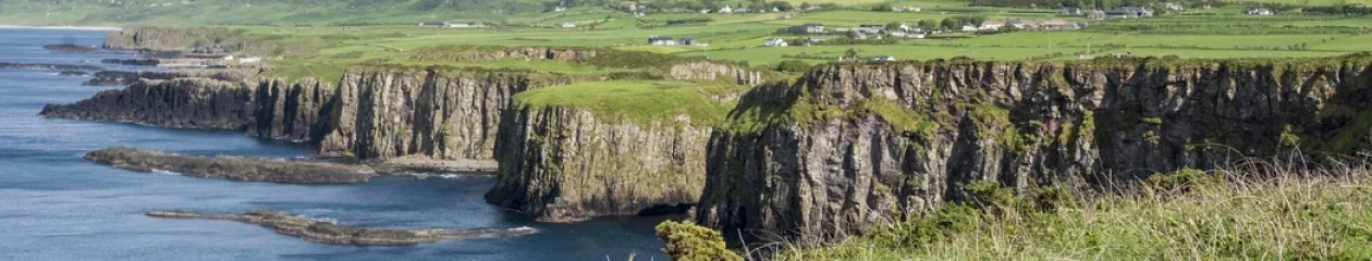
This is one of the top four destinations you should include in your New Zealand (NZ) itinerary. The Rotorua area is known as the best place to see colourful thermal pools and volcanic mountains in NZ. It is also a great place to meet Māoris, watch Maori craftspeople, see Maori dancing, enjoy a hangi banquet, and learn about their culture.
When we first visited the Rotorua and Tongariro regions we had never seen a thermal area or walked on a volcano before. We were amazed! Yes, Rotorua is very touristy but still worth visiting. Over half of the tourists are Kiwis. Most of them will be on vacation starting ca. December 20th for five to six weeks.
Google Place Ratings
All the points of interest are pinned to our custom NZ Rotorua-Tongariro Region Map. Each place name in this post is appended with the Google rating in brackets (e.g. G4.0). Any rating ≥ 4.0 is considered very good; ≥ 4.4 is considered excellent. Google is a much more trust-worthy indicator than travel booking sites.
Rotorua
Rotorua is a very small city of 58,900 residents, of which 35% are Māori. The Māori sailed from Eastern Polynesia and settled in Rotorua around 1325. The locals are outnumbered by the ca. 3.5 million tourists each year; however, half of them are Kiwis. Rotorua is an active geothermal area due to the Rotorua Caldera formed by a major volcanic eruption ca. 240,000 years ago.
Maori

We were very lucky to spend a few nights through a homestay exchange program with these Māoris at a marae in the non-touristy Gisborne region of NZ. The Māoris form 17% of the population of NZ. One major change since our first trip is the use of Māori names for major sights and the change to bilingual place name signs.
The Māori emigrated after 1320 in several waves from Polynesia. The ancestors of the Polynesians were the Lapita people, who sailed from Taiwan ca. 1100-900 BC. This has been determined by DNA and linguistic analysis; thereby refuting Thor Heyerdahl’s theory. The Polynesians used bird species, star gazing, cloud formations, and wave motions to find islands in the massive Pacific Ocean.
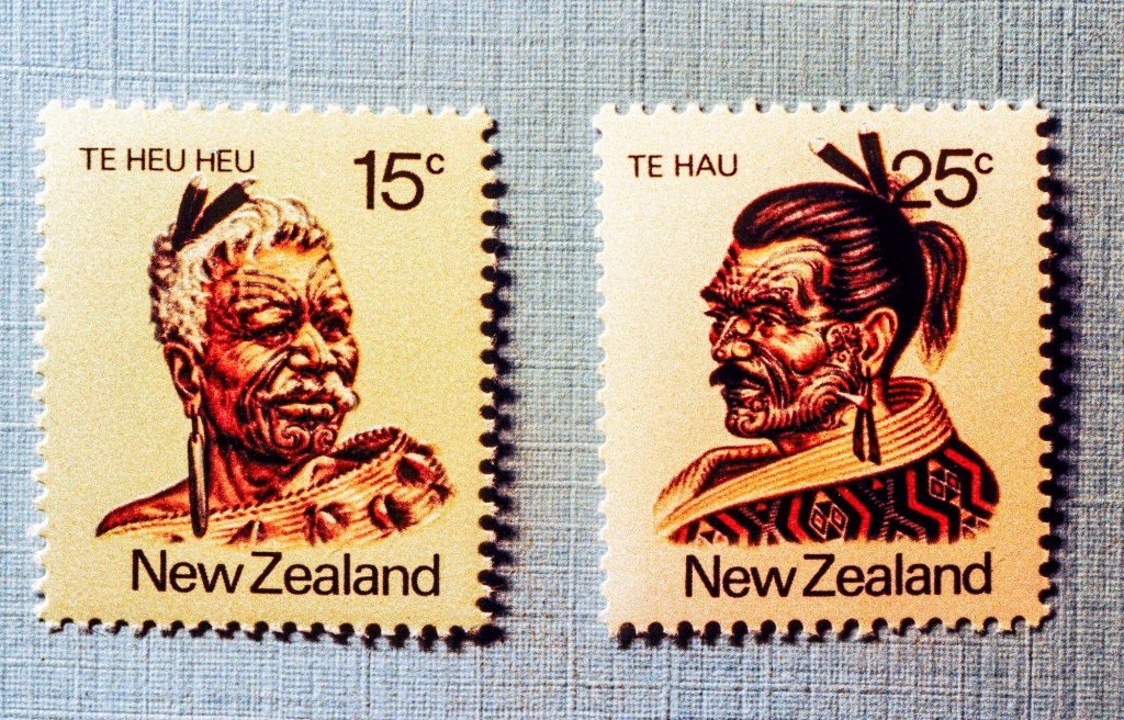
The 1980 commemorative stamp issue featured Maori leaders who made a difference. Te Heu Heu Tukino IV was a paramount chief of central North Island. Before his death, he bequeathed three mountain peaks — Tongariro, Ngauruhoe and Ruapehu — to NZ in 1887. This is very significant because these volcanoes became Tongariro National Park. Ngauruhoe (see below) was used as Mt. Doom in the Lord of the Rings movie.
Te Hau-Takiri Wharepapa was one of fourteen Maori who sailed to England in 1863 to meet Queen Victoria. He married an English woman. The reason for including these stamps is to show what traditional Māori men used to look like; in particular, the facial and body tattoos.
Tā Moko
Our word tattoo originated from the mispronunciation by Captain James Cook (1769) of the Tahitian word tautau. The Polynesians brought their tā moko (tattoo) art form to NZ.
It reflects an individual’s ancestry and is considered highly sacred. In earlier times, it was an important signifier of social rank, knowledge, skill and eligibility to marry. Many of the designs are universal. In particular, the spirals that swirl across the nose, cheek and lower jaw.
Koru
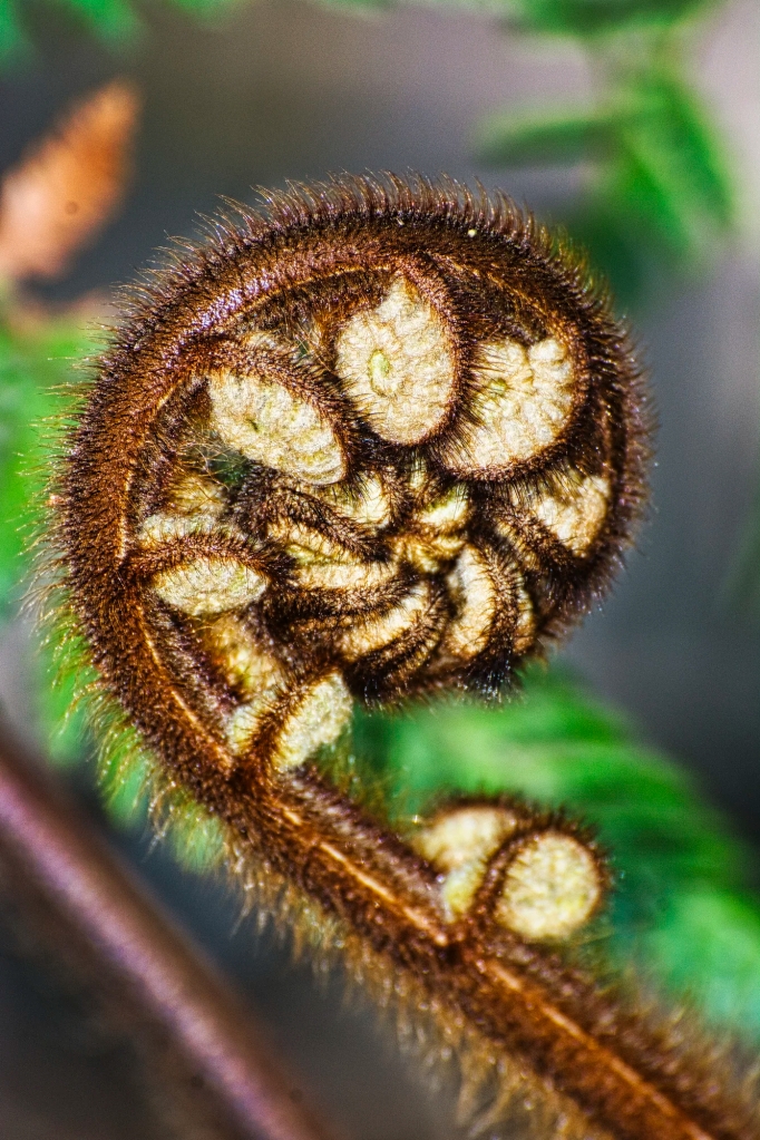
The tattoo motifs carry over to wood carvings. The koru (spiral) depicts new beginnings, growth and harmony. This symbol originated from the unfurled fern leaf. The silver fern is the most iconic symbol of NZ. It is used by the All Blacks Rugby team and Air New Zealand — and it almost became the new NZ flag.
Whakarewarewa
Whakarewarewa is a thermal area as well as Maori cultural experience located within Rotorua. Most locals just call it Whaka, which is pronounced “faka”. This must-see is the most accessible place, especially for those who do not have a car.
Te Aronui-a-Rua Meeting House
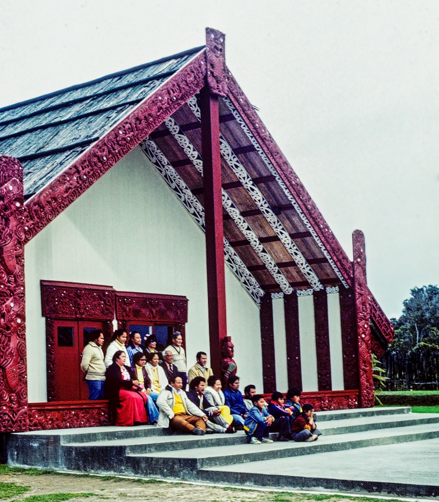
The carvings for the meeting house took ten years to complete. The central figure holding a mere mere club at the top represents the chief. Normally, the carved slabs would represent the ancestors but these were made for tourists.

Pataka is a food storehouse built on stilts to prevent the dogs from entering. However, the Māori staple kumara (sweet potato) was buried underground. Note the use of shiny paua (abalone) mother-of-pearl shells for eyes! Pāua are also associated with the symbolic eyes of ancestors that gaze down from the night sky. Definitely try paua fritters when you visit.
Tiki

The wood carvings are beautiful but they are very symbolic as well. There is a repeating pattern of tiki figures. The tiki is a talisman to the Maori people, and has been regarded as a good luck charm since ancient times. The tiki symbolizes fertility and is believed to represent the unborn human embryo. The figures are often portrayed with three fingers, representing the cycle of life — birth, life, and death.
Te Puia

Te Puia is a small Māori settlement that now serves as a museum of Māori culture and buildings. This was the site of the Māori fortress or pa first occupied around 1325. The Pataka looks like Thai spirit house but is used to store things.

The gateway into the pa depicts two lovers, Hinemoa and Tutanekai. Hinemoa was the daughter of a great chief who lived along the shores of Lake Rotorua. She was very beautiful, and because of her beauty and high rank, many young men desired her as their wife.
Tūtānekai was one of these would-be suitors, but he knew his rank was not high enough for Hinemoa’s father to accept him. Tūtānekai was content with gazing at Hinemoa from a distance, and yet it seemed that she would return his looks.
When Tūtānekai asked Hinemoa to leave her home and come to him, she agreed. Her people had suspected her intention, and they had pulled all the canoes high up on the shore. Instead, she swam towards the sound of Tūtānekai’s flute. Tūtānekai took her to his house and according to custom, they were married. They moved to Rotorua.
Maori Carving

There is a carving school to preserve Māori skills. Here is the beautifully carved prow of a canoe. The use of the spiral is a common motif.
Maori Weaving

A woman explained how Māoris used a shell to scrape off the outer layer of the flax at intermittent sections, leaving unstripped leaf in between. Only the exposed fibre absorbs the dye, creating a striped black and white effect.
A piupiu is a skirt-like garment made of these flax strands that hang from a belt. When the wearer moves, the strands sway to and fro. The word piupiu means to swing.
Geothermal Sights

Geothermal features can be found throughout the village. There are boiling mud pools sprinkled among houses. Frog’s Pond is a jumping mud pool.

The rotten egg smell is everywhere, not only in Whaka but all of Rotorua. Hydrogen sulfide gas is emitted by mud pools and geysers. Here sulphur is deposited on the silica. It is for this reason that Rotorua is often called the Sulphur City or Rotten-rua.
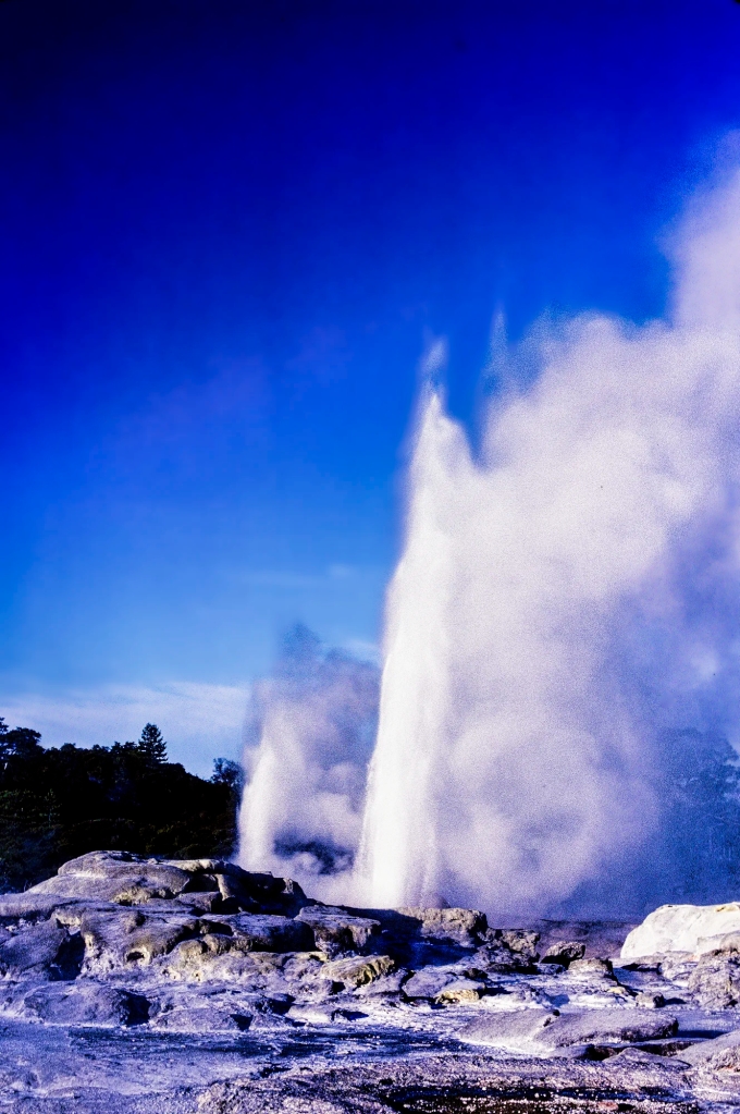
Pohutu Geyser

Pōhutu Geyser is the second largest in the world, after Old Faithful in Yellowstone NP. Pōhutu means big splash or explosion and it is a wonderful sight. The geyser erupts approximately hourly to heights of up to 30 m (98 ft).

Whakarewarewa has ca. 500 hot springs and 65 geyser vents. Seven geysers are currently active. Prince of Wales Feathers Geyser is the closest neighbor of Pohutu Geyser and always precedes it.

A progressive decline of geyser outflows started ca. 1970. The use of geothermal bores for heating in Rotorua had affected all geothermal features. The Bore Closure Programme in 1987-88 closed down all bores within a 1.5 km radius around Pohutu Geyser and another 120 wells outside that radius due to the punitive extraction fees. This resulted in a pronounced recovery in thermal activity.

As we left Whaka, we passed under Pohutukawa trees. The Maori name means splash of red due to the brilliant red blooms. As these trees flower from November to January, they are often called Christmas trees.
Whakarewarewa Hours and Fees
Hours: 0900 – 1600 hrs.
Fees: Self-Guided NZD 35 Senior $31.50 Child $15
All Day (Events) Pass NZD 99 Senior $89 Child $45
Website: Whakarewarewa
Geothermal Areas
Why are there so many volcanoes in NZ? Some of the well known volcanoes are Tongariro, Ruapehu, Ngauruhoe, Rangitoto, Taranaki, Tarawera, and the Banks Peninsula.
NZ is on the Pacific Ring of Fire where the Indo-Australian Plate is smashing over (subducting) the Pacific Plate. At this plate juncture, magma rises and volcanoes are formed. Earthquakes are another feature of NZ. The last horrific one registered 6.3 in Christchurch 2011.
Rotorua is not the only place with geothermal activity in NZ. Hot Water Beach in the Coromandel, Hanmer Springs in Canterbury, hot springs near the Fox and Franz Josef Glaciers, and Tekapo Springs near Lake Tekapo are some of the better known places. Geysers erupt when underground water is heated above the boiling point and forcefully expelled into the air.
Waimangu Volcanic Valley

Waimangu (G4.7) offers a pleasant downhill walk past colourful thermal pools and steaming vents. We walked the whole way so we could see all the sights at our own pace. There is a free shuttle bus between the sights but we took the bus all the way back (uphill) from the end of the trail. The stop numbers below come from the Waimangu Volcanic Valley map.
Waimangu Southern Crater

Stop 1: The Southern Crater is the southern-most crater of the original Mount Tarawera eruption.

This is the view of Southern Crater 30 years later.
Frying Pan Lake

Stop 2: The 4 hectare (10 acre) Frying Pan Lake (G4.6) is the world’s largest hot spring. The lake was formed by a 1917 eruption that buried a nearby hotel.

There is also the empty crater of Waimangu Geyser, which used to be the world’s highest at an incredible 488 m (yards) high!

The boiling lake is guarded by the Cathedral Rocks, the remains of a dome composed of rhyolite lava with steam still escaping. Rhyolite is a rare, silica-rich volcanic rock. Why is that important? For the answer, read on until the end of the hike, Mount Tarawera.
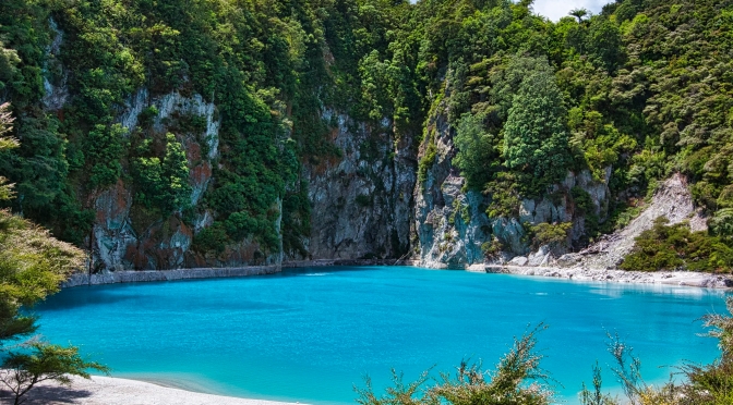
Inferno Crater Lake

Thanks to the colour, Inferno Crater Lake (G4.8) was our favourite place along the hike. However, the cool blue lake is boiling hot at 80 °C (176 °F). Why is the lake a brilliant blue colour. Only the blue spectrum is reflected back off the silica particles suspended in the water.
But the lake is also unique because there is a geyser inside it — at the bottom! This explains why the lake rises to overfilling then recedes as much as 12 m (yards) lower!
Valley Viewpoint

ca. Stop 7: There was a wide open view of a verdant valley. The Waimangu Valley was wiped out by the Terawera eruption in 1886. It has been totally re-vegetated by nature. We saw tropical tree ferns that grow here due to the warm and humid micro climate.
Tree ferns date back to 360 million years ago and were decimated along with the dinosaurs by the Cretaceous Mass Extinction Event 65 million years ago. The tree ferns survived in damp, shady habitats in NZ, Tasmania, and South Africa.
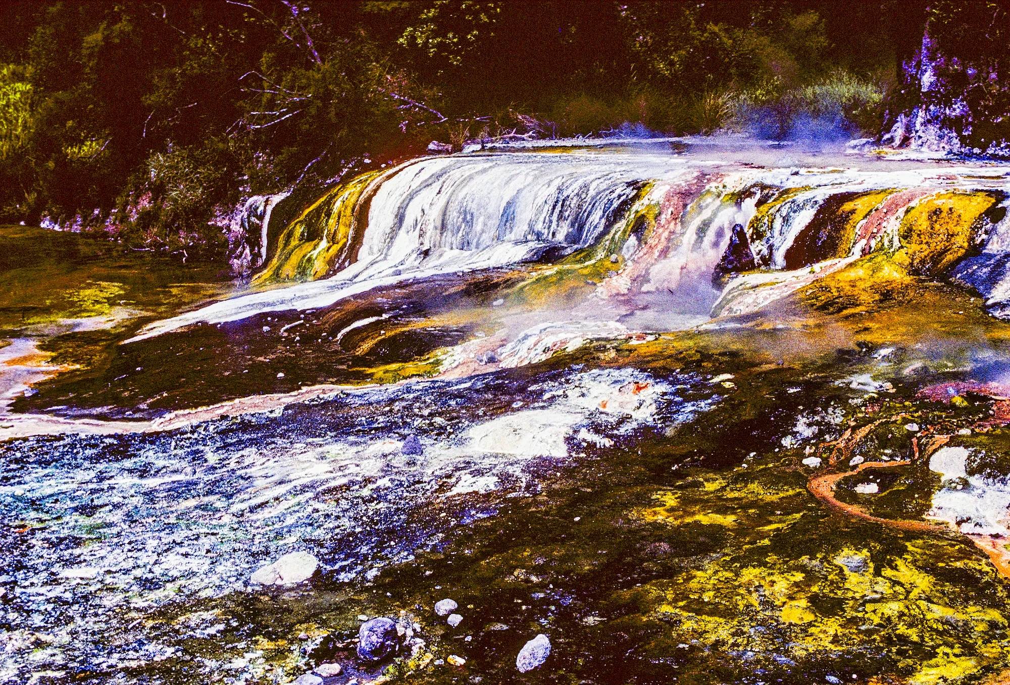
Colourful Hot Stream

>= Stop 9: Continue walking along the outlet hot stream with colourful banks. Minerals percolate out of the water. Colours indicate the minerals deposited: purple is manganese oxide.

As the water cools, it deposits minerals that form a palette of yellows (sulphur), oranges (antimony, arsenic), reds (iron oxides), and whites (silica) along the stream.
Warbrick Terrace
Stop 12: Warbrick Terrace is the last muli-coloured terrace. In the 1890s, Alfred Warbrick was an explorer and guide at Waimangu. He used sandbags to dam the flow of a small hot spring visible at the top, which created this terrace.
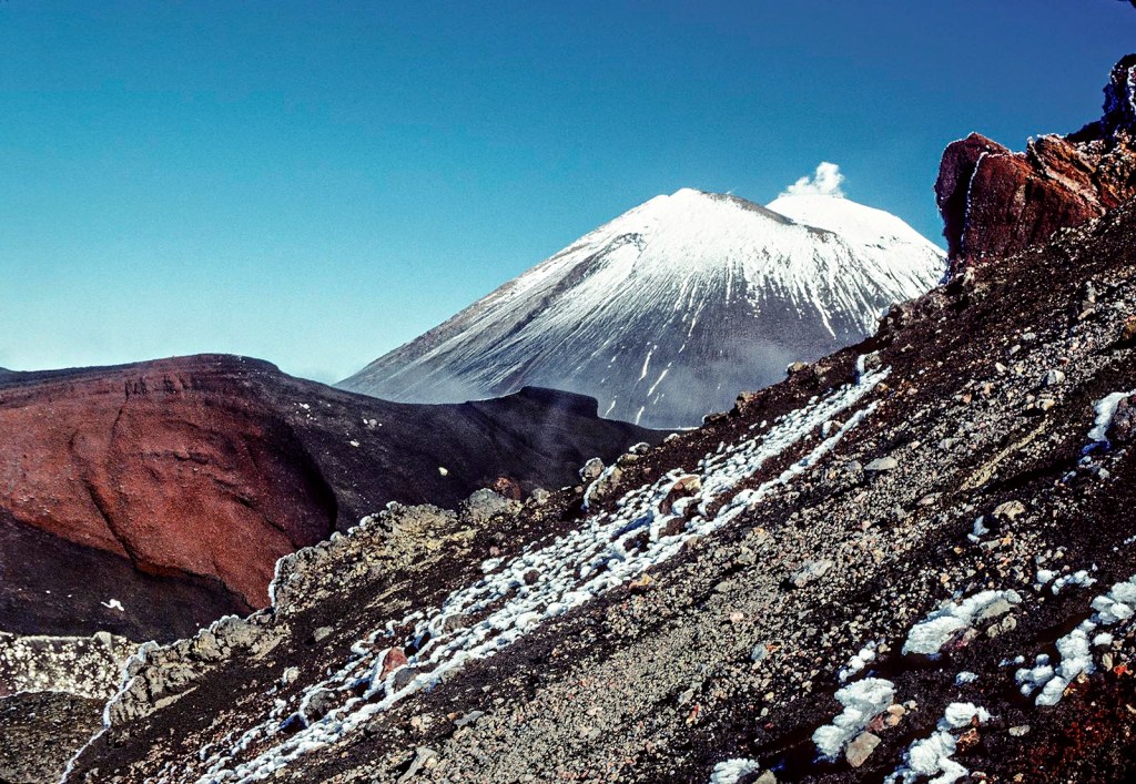
Mount Tarawera

Stop 17: At the end of the walk is a boat ramp for cruises of Lake Rotomahana, where we saw a black swan. This was an introduced species brought from Western Australia in the 19th century.

In the background is a view of Mount Tarawera, though this photo was from a different road. Rhyolitic magma is high in silica and gases, which makes it more viscous. But the high viscosity prevents the gases from being released and resulted in a massive explosion. The 1886 eruption that split the volcano in two was heard as far as Christchurch 677 km (421 mi) away! Lake Rotomahana covers the site of the famed Pink and White Terraces, which was the top thermal wonder of the world.
Waimangu Hours and Directions
Hours: 0830 – 1700 hrs.; last admission 1530 hrs.
Fees: NZD 46 Child $16
Trail: 4.2 km OW, 2.5 hrs; take bus back uphill
Directions: from Rotorua drive south on Hwy 5 for 14 km;
turn east on Waimangu Rd for 6 km
Activities: Lake Rotomahana Boat Cruise
Website: Waimangu Volcanic Valley
Wai-o-tapu Thermal Wonderland

We loved our day at the pool! Wai-o-tapu (G4.6) is a photographer’s dream with colourful thermal areas and frothing geysers.
Lady Knox Geyser

If you have a car, you will want to visit Lady Knox Geyser (G3.9) located on a separate side road. It is not active except at 10:15 daily. However, it is induced to erupt by dropping a surfactant into the opening of the vent. It may look small but it fires hot water 21m (69 ft) into the air.
Wai-o-tapu Trails
There is one big loop trail divided into three overlapping loops. We would recommend doing all three overlapping loops. The short Red Loop and Orange Loop (colours and stop numbers come from Wai-o-tapu’s own map) are easy and flat until the stairs at the end of the Orange Loop.
Red Loop stop 2: Rainbow Crater is composed of kaolin clay (the pale clay used to make porcelain). It has veins of red (iron oxide) and yellow (sulphur). Steaming vents opposite the crater are called fumaroles.
Artist’s Palette

Red Loop stop 5: Artist’s Palette is a 10,000 m² silica terrace covered with yellows (sulphur), reds (iron oxide), and limes. Champagne Pool is in the distance.
Panoramic View

Orange Loop Stop 11: This is a panoramic view of Frying Pan Flat, which is strewn with hot springs, fumaroles, and boardwalks.
Champagne Pool

Red Loop stop 21 comes on the way back: Champagne Pool (G4.8) was formed 900 years ago by an eruption, resulting in a crater ca. 62 m (203 ft) deep. The water exits the bottom at 260 °C (500 °F) and “cools” down at the top to 73 °C (163 °F).

The hot spring rises full of carbon dioxide gas, which bubbles at the surface just like a flute of bubbling champagne. Other gases released include methane (CH4) and hydrogen sulphide (H2S). When we first stopped there was so much mist I could not take any photos.

The colourful deposits along the edge are in sharp contrast to the grey-white silica sinter surrounding Champagne Pool. Contrary to one web site, the orange rim is not algae. The bright orange comes from arsenic and antimony. The arsenic is found in the mineral orpiment (As2S3). Don’t even think about touching this pool!

Arsenic is a key component of poisons, pesticides, car batteries, and gallium arsenide semiconductors. Antimony stibnite (Sb2S3) is used in lead and tin alloys for bullets, bearings, and semiconductor devices. It was also used to make an eyeliner (kohl) as far back as predynastic Egypt, ca. 3100 BC. The ultra-black kohl eyeliner is still used in the Middle East and South Asia but is banned in the West due to its high lead content.
Devil’s Bath

Red Loop stop 25: Devil’s Bath is a surreal lime colour.

The bath colour varies according to amount of water that seeps in from Champagne Pool mixing with sulphur (yellow) and iron (red) deposits.
Wai-o-tapu Hours and Directions
Hours: 0830 – 1630 hrs; last admission 1500 hrs
Fees: Adult NZD 45Child $15
Directions: drive south on Hwy 5 for 27 km; turn east towards Waiotapu Tavern; turn left for 2 km
Trails: Red Loop (1.5 km 30 mins RT), Orange Loop (2 km 40 mins RT), and Yellow (3 km 75 mins RT) loops
Visit Time: 2 hrs — actual time will be much longer if you spent a lot of time admiring or photographing the sights
Website: Wai-o-tapu Thermal Wonderland
Orakei Korako
Orakei Korako (G4.7) is a highly active geothermal area most notable for its series of fault-stepped sinter terraces. On our first trip to NZ, we hitchhiked the 21 km side road and did the walk with a Samoan-Kiwi family. I don’t even remember seeing other tourists here, though it was late May (autumn).

It requires a boat ride across the lake then a loop trail through the geothermal area. The lowest terrace at Orakei Korako is the jade-green Emerald Terrace, the largest of its kind in New Zealand.

Greens, oranges, yellows and browns colour the Rainbow Terrace and Cascade Terrace.
Golden Fleece Terrace

The third and largest great fault scarp in the valley is called the Golden Fleece Terrace. It is not golden except for mineral flows below the terrace.

The Māori name Te Kapua (“The Cloud”) is a much better description. However, we feel it should be named the Sheep Fleece, since that’s what it looks like to us.

The terrace is massive compared to the closeup photos displayed — it is 5 m (yards) high by 40 m (yards) wide. The white colour means it is silica. In fact, it is the largest silica terrace in the world.
Above this terrace is the Artist’s Palette, a 10,000 m² silica sinter terrace covered with clear blue alkali chloride pools. On the way back we passed Elephant Rock and the Soda Fountain.
Orakei Korako Hours and Directions
Hours: 0800 – 1600 hrs; last boat returns at 1600 hrs.
Fees: NZD 47; Child $21
Directions: drive south on Hwy 5 almost to Taupo; turn west on Tutukau Rd for 16 km; turn right onto Orakei Korako Rd for 5 km to the end of the road
Trail: 1.9 km loop; 28 mins.
Visit Time: 2.5 hrs.
Website: Orakei Korako Thermal Park
Rotorua City
There are many activities to do in tourist trap Rotorua. But did you come all this way to do things you could do at home? Alternatively, you can tour the Whakarewarewa Forest or drive around the lakes.
Maori Hangi and Concert
On our first trip to NZ, we went to hangi at one of the hotels. We were stuffed with steam-cooked lamb, wild pig, chicken, tumara, pumpkin, venison stew, tender eel and Maori bread. The concert following the meal featured beautiful soprano voices and poi dances. Two Scottish women were brought onto the stage to participate! The Maori women touched noses with each of them. Then four Maori men surrounded them and did a haka that frightened the daylights out of them. Traditionally, haka is a customary way to welcome visitors, but it also served to show physical prowess.
Rotorua Buildings

There were only a couple of town buildings that begged to be photographed. The most interesting buildings are the Maori meeting houses with their richly carved posts. Rotorua houses come with steam and sulphurous smells.

The Rotorua Museum of Art and History (G4.3) is one of the most beautiful buildings in Rotorua. The surrounding Government Gardens provide wide open views of the ornate building.
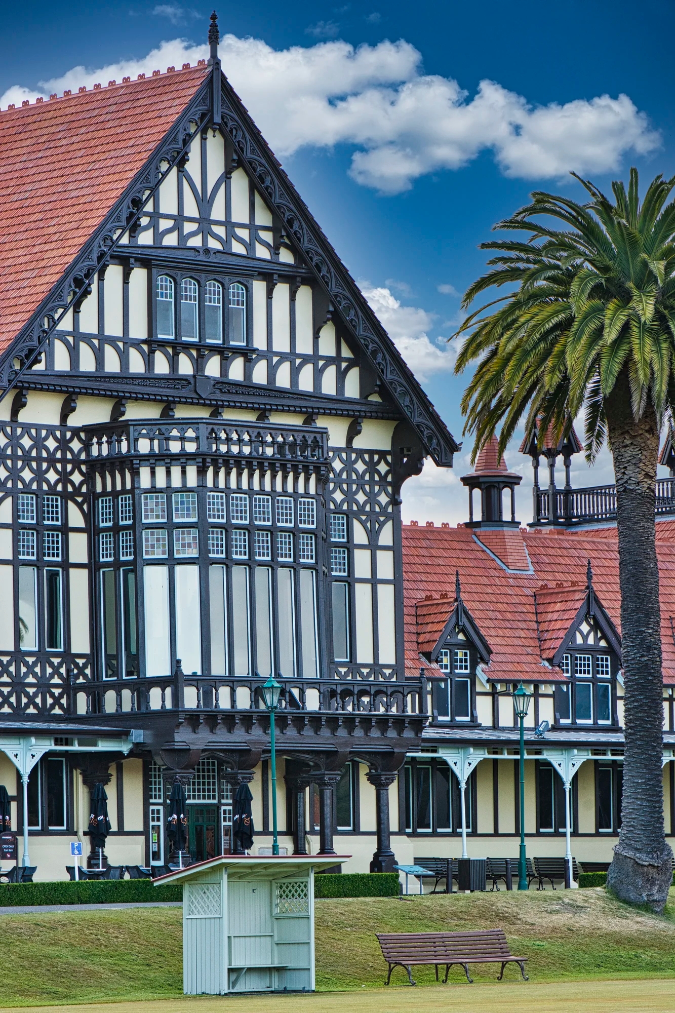
The Tudor-style building was constructed in 1908 for the Great Spa of the South Pacific.

Prince’s Gate Hotel (G4.0) is an attractive building with a more amazing history. It was built in Waihi in 1897, a gold rush mining town 120 km to the north. During the 1919 Flu Pandemic it served as a hospital. In 1920, the hotel was disassembled and transported to Rotorua where it was reconstructed. From here you can walk to Kuirau Park (G4.5), which has a public thermal area.
Rainbow Springs
Another place to visit used to be Rainbow Springs (G4.3). It is named for the rainbow trout swimming in the spring, which discharges 4.5 million litres (400 million gallons) of water per day! It is just mind boggling. It was a pleasant walk if not a must see.
Barbary Dove

We saw a very tame Barbary Dove which posed along the fence banister for us. We could easily have touched it. Yes, we were that close though I did crop the 50 mm lens photo a little bit.
It is an “escape” from birds imported from Northern Africa. Our third visit to NZ was also a birding trip for our son. There are lots of interesting endemic and flightless birds in NZ, another reason to visit.
Kea

An inquisitive Kea (endemic parrot) bounced around trying to grab a piece of our backpack or other “toy”. This is my favourite NZ bird. Yes, we were that close – I used an 86 mm focal length.
However, we just read that this nature park will be closed. Fortunately, there are many other places in NZ to see a kea. In fact, this photo was taken in Fiordland NP.
Agrodome
At the Agrodome (G4.5) we saw demonstrations of sheep dogs and sheep shearing featuring 19 different species of sheep. This is worth doing to gain a better understanding of one of NZ’s major industries. NZ has 5 million people and 25 million sheep! We used to tease our Kiwi friends about giving sheep the vote.
Sometimes Kiwi English seems like another language. Kiwis use a lot of cute expressions, some related to sheep. Our favourite was “be a dag and drop off”, which translates as get lost. Dag is the sheep poo that hangs onto the wool near the bum.

On our first trip to NZ, we stayed at the Pitts-Brown sheep farm in the Waitomo area. One thing we learned is that sheep are pretty intelligent and knew right away we wanted to shear them. The sheep dog did a superb job of getting the sheep to the shearing area. Our host above made it look easy. I had a go at shearing two sheep. It was not an easy task. The sheep knew right away I was a newbie. Sheep are heavy and you have to hold them firmly with only your legs as you need your hands for shearing.
Agrodome Hours and Directions
Hours: 0900 – 1700 hrs; last boat returns at 1600 hrs.
Fees: NZD 49; Child $25
Directions: 141 Western Road, Ngongotahā: from Whakarewarewa drive north for 13 km on Hwy 5 just past Hwy 36 junction
Shows: 9:30 11:00 14:30
Farm Tours: 10:40 12:10 13:30 15:40
Website: Agrodome
Huka Falls

The beautiful green Waikato River is forced through a canal like gorge.

Then the water tumbles down the frothy, thundering Huka Falls (G4.8).

There were a couple of viewpoints on both sides of the gorge that are worth finding.
Nearby is the Huka Honey Hive (G4.5), where you can taste and buy the unique honeys produced in NZ. It not the bees that are different. It is the unique native flora like pohutukawa and manuka that give the unusual flavours to Kiwi honey.
Wairakei Thermal Station shows how geothermal steam can be used to generate power but you will mainly see a field of silvery pipes.
Huka Falls Hours and Directions
Car Park Hours: 0800 – 1800 hrs? but falls are open all day
Directions: 73 km 55 min. from Rotorua drive south on Hwy 5, cross over Hwy 1 onto Wairakei Drive to Huka Falls Lookout. Footbridge to the east bank is just south of the falls near 2nd parking lot. Huka Falls is just north of Lake Taupo.
Craters of the Moon

Craters of the Moon (G4.2) does not offer spectacular thermal pools. But if you are a budget traveller or backpacker, it is a less expensive thermal area. We walked 2 km from the parking lot on pleasant dirt road. It is dangerous to walk off the track. A girl died here. A truck parked in the wrong place disappeared when the “solid ground” suddenly became a mud pool.
The first pool with vigorous boiling mud was the most dramatic. Also amazing was the algae, cushion moss and low lying variant of kanuka trees that can withstand the hot steamy environment. The track climbed a hill that gave a view of the thermal area with Taupo and Tongariro volcanoes in the background. It looked like the hill was on fire. The track is supposed to take 38 minutes but we spent two hours here.
Craters of the Moon Hours and Directions
Hours: 0930 – 1700 hrs; last admission at 1600 hrs.
Fees: NZD 10; Child $5
Directions: 171 Karapiti Road, Wairakei Park: from Rotorua drive 73 km south to Huka Falls Road but turn west onto Karapiti Road
Shows: 9:30 11:00 14:30
Farm Tours: 10:40 12:10 13:30 15:40
Website: Craters of the Moon
Te Ponanga Saddle Viewpoint

While not hidden, Te Ponanga (G4.6) is a great viewpoint you could easily drive by. It is 68 km (one hour) south of Huka Falls at the beginning of Highway 47, the road to Tongariro NP.
You may not be so impressed with the view until you learn the significance of what you are seeing. Lake Taupo has an area of 616 km² (238 sq mi). This is larger than Phoenix AZ or San Antonio TX and a bit smaller than Edmonton AB.
While Taupo looks like a lake, it is hard to believe this is the flooded caldera of a supervolcano. That means it had an eruption with a Volcanic Explosivity Index (VEI) of 8. You would not have wanted to been here ca. 26,500 years ago when it spewed out over 1000 cubic kilometers (240 cubic miles) of debris. The is the world’s most recent VEI-8 eruption.
Frequently Asked Questions
Abbreviations
Kiwi = New Zealander, or a nocturnal flightless bird
NP = National Park
NZ= New Zealand; NZD = New Zealand Dollar
OW = One Way
Getting to Rotorua
Most international travellers will fly into Auckland. Even when we flew from Wellington or Christchurch, we had to transfer in Auckland. There are only a couple of ANZ flights to Rotorua daily.
The easiest way is to get to Rotorua is to rent a car and drive 230 km. Alternatively, one can go by bus.
Getting Around Rotorua
When we were backpacking, we walked or hitchhiked to the various sights. Rotorua city buses cost $2.80 for cash fares and there is also a fare card for longer visits. The best and most flexible way to get to all the sights is a rental car.
There is a “shuttle bus” service, which means only one departure per day per bus company to either Waimangu or Wai-o-tapu departing Rotorua Visitor Centre at 1167 Fenton Street. There is a fixed return fare for the bus including the park entry fee. This means you can only see one thermal area per day.
- Thomque Ventures departs the Rotorua Visitor Centre at 0900 hrs and departs Waimangu at 1330 hrs. NZD 109
- Thomque Ventures departs the Rotorua Visitor Centre at 0900 hrs and departs Wai-o-tapu at 1330 hrs. NZD 199
- Thermal Land Shuttle departs the Rotorua Visitor Centre at 0815 hrs and departs Wai-o-tapu at 1300 and 1645 hrs.
In other words, the more people in your group, the more economical it is to rent a car.
Where to Stay in Rotorua?
We do not have any affiliate links and we are not recommending specific places. The alternative types of accommodation are hotels, youth hostels, B&Bs, campsites, and cabins at campgrounds. The latter is an excellent and better value than a hotel room.
Search for possible accommodation via our NZ Rotorua-Tongariro Region Map. Every hotel has a Google Map rating. Any rating ≥ 4.0 is considered very good; ≥ 4.4 is considered excellent. This same technique can be used to choose restaurants.
Instead or relocating each day, Rotorua could be used as a base to explore the surrounding countryside, as shown on our NZ Rotorua-Tongariro Region Map. Nearby areas include Waitomo Caves and Taumarunui.
What is the Best Time to Visit Rotorua?
What is the best month to visit Rotorua? Many sources say that the best time to visit New Zealand is during the summer months of December to March. Really, you can visit North Island any time of the year though you may find winter (June to August) to be too cool and wet. It’s balmy compared to the frigid cold temperatures of the Great North.
Here is a temperature chart of the average minimum and maximum temperatures for the three winter months (June-August in NZ).
| Place, Country | Min Temp | Max Temp |
| Auckland, NZ NI | 8.2 °C 46.8 °F | 15.2 °C 59.4 °F |
| Rotorua, NZ NI | 8.3 °C 46.9 °F | 14.3 °C 57.7 °F |
| Tongariro NP, NZ NI | 2.0 °C 35.6 °F | 9.0 °C 48.2 °F |
| Ottawa, CA | -14.4 °C 6.1 °F | -3.2 °C 26.2 °F |
The rest of the year is perfectly warm in Rotorua with an average high of 23 °C (73 °F) in the summer and 17 °C (63 °F) in the spring and fall. The highest sunshine is from October to March.
June to September are the rainiest months with between 13.7 to 16.9 rain days per month. The rainiest months are April (176 mm 6.9 in), May (163 mm 6.4 in), June (188 mm 7.4 in) and August (168 mm 6.6 in).

By contrast, the alpine area of Tongariro NP should be avoided from May to October. On our first trip to NZ, we did the three-day Tongariro Alpine Crossing in late May. It was gloriously sunny but freezing cold in the morning — especially since we brought no winter clothing on our three-year Round The World trip.
How much Time Do You Need?
You can drive through this area in three days. You need much more time to enjoy the scenery, visit thermal areas, and go hiking.
What are the Must Sees of NZ?
Which part of NZ is most beautiful? This is a difficult if not impossible question to answer as all of NZ is beautiful. This is not a flippant comment. One quintessential feature of NZ is that the journey from point A to point B is just as spectacular as the destination. Enjoy the trip and look for photo opportunities wherever you drive.
So far we have identified the top two sights any itinerary to NZ must include. The Rotorua Region in North Island is the first place we visited in NZ. The Southern Alps (Aoraki area) in South Island offers the best alpine scenery in NZ. These two should be on your New Zealand bucket list. If you want to see Quintessential New Zealand, we would use these two areas as the foundation for any itinerary you would plan.
Is Switzerland More Beautiful than NZ?
The wide open views of NZ and sheep grazing meadows (called “alps” by the Swiss) are similar to the feeling you get travelling Switzerland. But can you really say that Switzerland is the most beautiful country?
What to Read About New Zealand
Lonely Planet New Zealand — their website
New Zealand, Lonely Planet — the book, but nowadays most people use the internet
Maori Tattoo: The Definitive Guide to Ta Moko, Zealand Tattoo
Tā moko, Pure New Zealand Tourism
AA Maps — If you like paper maps or as backup to your cell phone app, get excellent detailed regional and city maps at an AA office, if you are a CAA or AAA member.
Other Posts You May Like
The following posts are the best places to visit in NZ:
- Lake Wakatipu and Routeburn Track
- Fiordland and Milford Sound
Custom Maps and Facts to Plan your Itinerary
NZ Rotorua-Tongariro Region Map
This post answers questions such as:
- What time of year is best to visit New Zealand?
- Should I visit North Island or South Island?
- Do you need a car to explore New Zealand?
- Where are the best hiking trails?
- How do I plan an itinerary for New Zealand?
- How many days are enough for New Zealand?
- Which parts of New Zealand should I visit?
- What does this Kiwi word or expression mean?
