I enjoy macro photography of flowers and used to specialize in wildflowers in the Canadian Rockies when we lived in Alberta. We love the colour, patterns, and textures of our beautiful flowers.
Our recommendations are not influenced by affiliate links – we have none. Our content and advice is derived from our personal experience, and knowledge based on photographing and editing for 23 years of travel and living around the world. I am an avid hiker, nature lover and photographer (all photos in our web site are my own). I particularly love travel photography (which includes many genres from landscapes to portraits).
Photography with Canon RF 100 mm Macro Lens
While we suffer through the high temperatures and even nearby tornados, our day lilies and other flowers are loving the heat. I also enjoy macro photography of flowers and used to specialize in wildflowers in the Canadian Rockies when we lived in Alberta. We love the colour, patterns, and textures of our beautiful flowers. Plus I am getting practice with my new Canon RF 100 mm macro lens.
Flock of Day Lilies
Being further north, our garden is just starting to fully bloom. This is the somewhat “wide angle” view preferred by Corinne. She also does not like the use of saturation or enhancement.
Day Lily 100 mm Macro
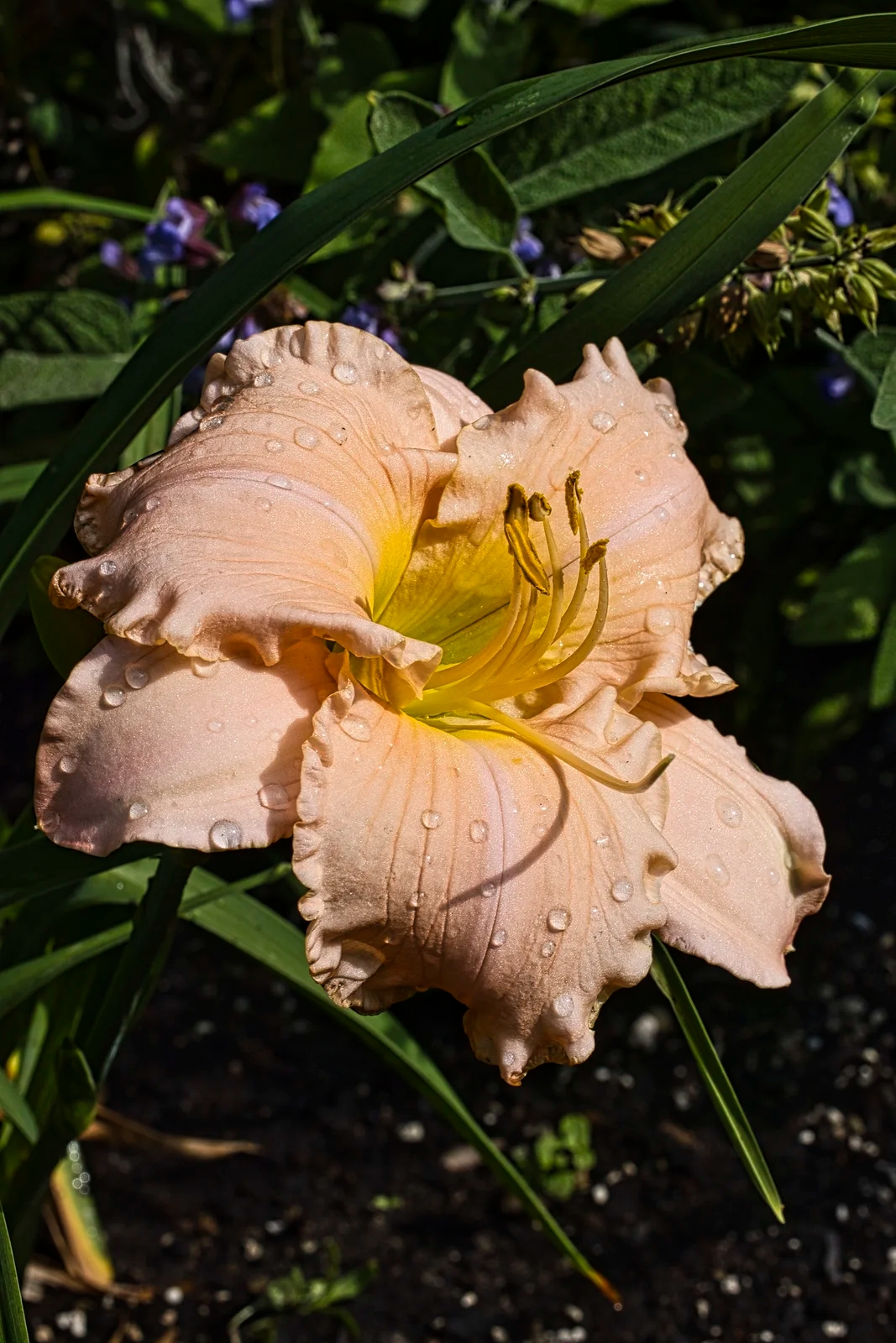
I prefer the macro view of one particular flower. Since I also bought a new Canon R5 (RF) camera I had to upgrade my Photoshop software. Instead, I got the less expensive Luminar Neo. In the above image, I did not use the Saturation or Enhance feature but I did use the Exposure, Contrast and Structure (Clarity) sliders.
Lobelia, Gaillardia and Impatiens
We are also growing from left to right, Lobelia, Gaillardia, and Impatiens. I also planted Lobelia and Impatiens in the partial shade garden. All of these plants did well this summer. We also have spring flowers, especially tulips.
Gaillardia (Blanket Flower)
Gaillardia is a perennial that seemed to have disappeared over the winter. But now it has grown even wider than last year. Gaillardia prefer full sun and are drought tolerant. The common name is Blanket Flower because the colour patterns are similar to Indigenous blankets.
Day Lilies
Pastel Peach Day Lily
We prefer flowers that bloom all summer and have a large number of day lilies. The Hemerocallis species are native to east Asia (China, Korea, Japan) and southern Siberia.
Ruby Red Day Lily
Most of our neighbours prefer tiger lilies but we love the day lilies. The flower only lasts a day, but the next day there is a new firework of blossoms. We love the fringed edges of this colourful red day lily.
Violet-Yellow Day Liiy
We love the fringed edges of this colourful purple and yellow day lily.
Calibrachoa
I also planted a crimson-violet border flower called Calibrachoa, cultivar Red Fox. This flower was a very pleasant surprise that we will have to re-plant next season. Calibrachoa is easier to grow than it is to spell! It expanded very quickly. Calibrachoa are closely related to Petunia. They are found in open grasslands from southern Brazil to Peru and Chile. That explains why they like full sun.
Other Posts You May Like
If you love flowers and macro photography, here are some related posts:
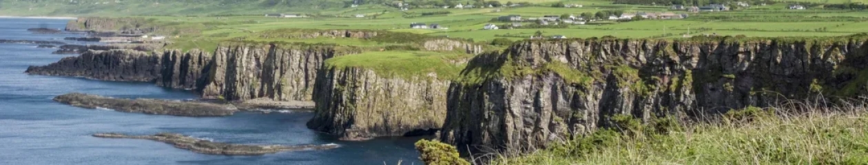
Yoho is a Cree word that means “awe” and Yoho National Park (NP) is awesome. There are three areas in Yoho NP that beg for your attention. Emerald Lake is one of our top five favourite glacial green lakes. Thundering Takakkaw Falls is the second tallest waterfall in Canada. The piece de resistance is the alpine scenery surrounding the unusual baby blue Lake O’Hara that comes with exciting hikes surrounded by high mountains.
These and other points of interest have been pinned to our customGoogle map, BC Yoho and Glacier NPs Map. Our recommendations are based on our experience living in Alberta for ten years. We are avid hikers, nature lovers and photographers. The Rocky Mountains were our weekend playground.
Yoho was the second Canadian NP created in 1886 and is part of the Canadian Rocky Mountains UNESCO World Heritage site, in part due to the Burgess Shale sites featuring fossils from 540 million years ago.
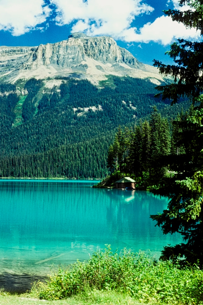
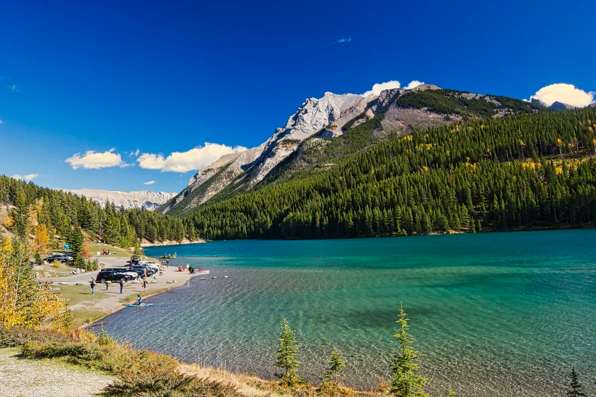
Emerald Lake
A View from the Bridge
Driving to an altitude of 1884 m (6181 ft) asl, you arrive at one of our top five turquoise lakes in the Rockies. Emerald Lake really looks emerald green. What causes the blue-green colour? Blame it on the glaciers as explained in the Icefields Parkway – Do not Miss the Best Road Trip in Canada.
Yoho has 15% of the number of visitors that go to Banff NP and Lake Louise. However, many Banff visitors also go to nearby Emerald Lake. Nowadays, in order to find parking in the limited space, come early in the morning — or late in the day but the mountains may be in the shade. You can also park further away and walk. We simply waited in the parking lot until someone left. As in any tourist place, the busiest time of the day is between 10:00 and 15:30 hours.
Emerald Lake Reflections
The road is open year round but for cross country skiing during the frigid winter of high altitude mountains. During summer, the bridge to the lodge is crowded with tourists taking selfies. The bridge does have the best views nearest to the parking lot. Most people take a few photos and perhaps grab a coffee then leave.
Emerald Lake Circuit Trail
Emerald Lake
The scope of the view of Emerald Lake from the bridge is limited to a small section of the lake. Instead, you should walk on the east side along the lakeshore past the picnic area. This is a flat trail until you get to the other end of the lake 1.4 km at the Yoho Pass Trail junction. There are views all along the way. For an easy and short walk, return the same way as the full circuit trail is 5 km.
Skiing the Emerald Lake Trail
The rest of the trail is up and down and also inside a thick forest of Engelmann Spruce and Western Red Cedar without views until you return to the Lodge. In the winter, this loop becomes a cross country trail. We came here on the weekend to avoid the downhill crowds at Lake Louise and Sunshine.
Yoho Pass –Burgess Pass Loop Trail
We walked this trail with my sister and brother-in-law, who are novice hikers. We combined parts of three hikes described in the Canadian Rockies Trail Guide (see below). The first part of the trail was the flat lakeshore walk. At the end of the lake we made a left turn up a steep, partial ascent of The President and Michael Peak to Yoho Pass. There are a couple of trail options here as well.
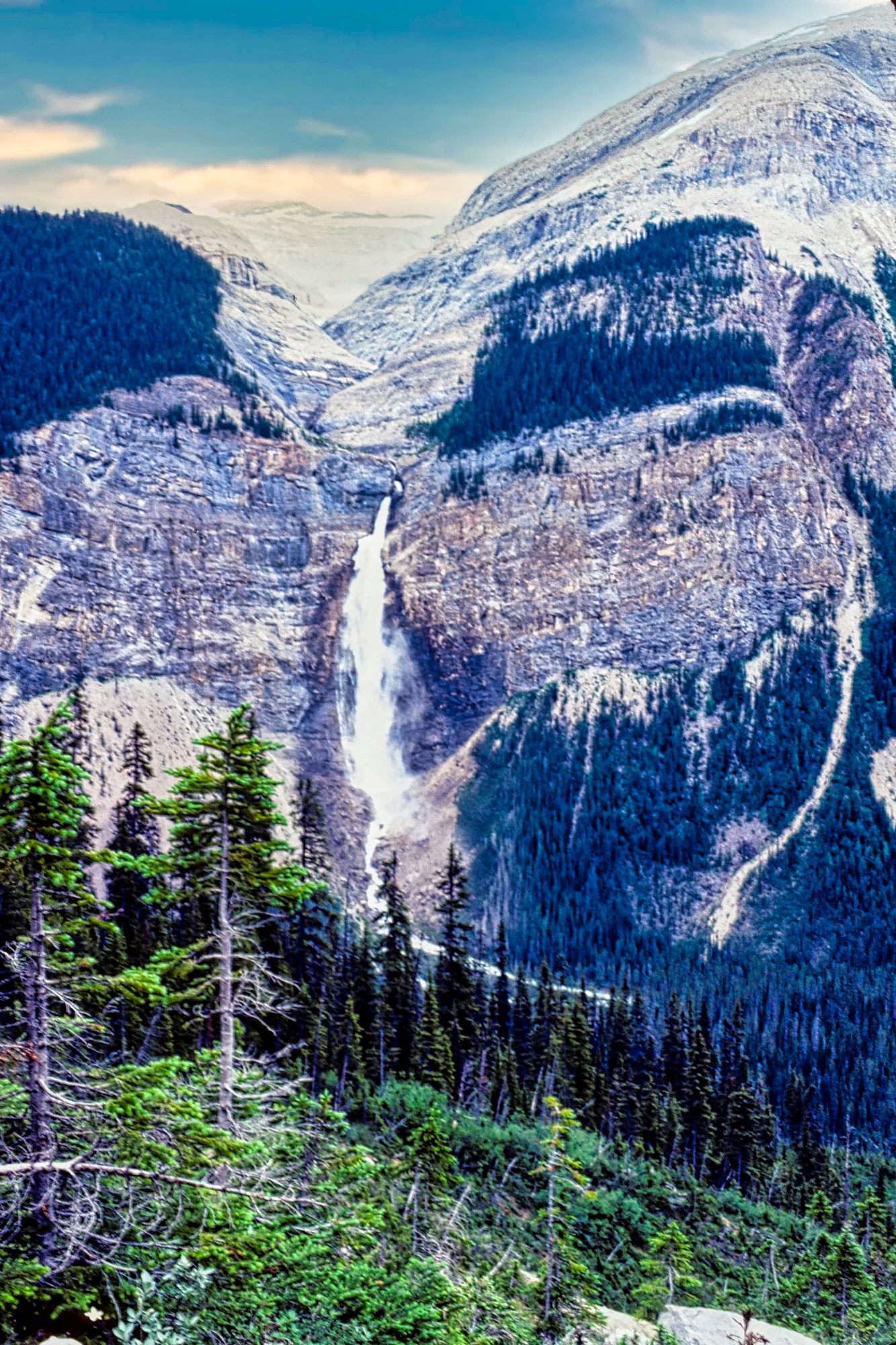
View of Takakkaw Falls from Yoho Pass
From Yoho Pass at km 6.3 we had a dramatic view of Takakkaw Falls, which is straight across the Yoho Valley. You can see part of the Daly Glacier on top of the massive Mt. Daly but you cannot see the glacial lake behind the mountain top. Unfortunately, the weather was too hazy for a good photo but it’s the only image I have. I replaced the pure white sky as well using my photo editor.
Over halfway through the loop, we came to an un-bridged brook that was now a gushing torrent. It had been raining earlier but we decided it was better to continue on. Even worse, the crossing had a very steep drop off cliff on the right side. You do not want to fall the wrong way. As we had hiking boots, we formed a line across the stream and helped the non-hikers to cross the rocks someone had laid down. They were real troopers and did not complain.
We continued south along the shoulder of Mount Burgess and reached Burgess Pass after about 6 km. Here we turned onto the forested trail west and downhill 6.8 km to Emerald Lake.
Yoho Pass – Burgess Pass LoopTrail: > 19.1 km, > 8 hrs RT; gain 296 m (969 ft); Elevation: Yoho Pass 1830 m (6000 ft); Burgess Pass 2180 m (7150 ft);
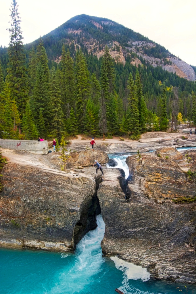
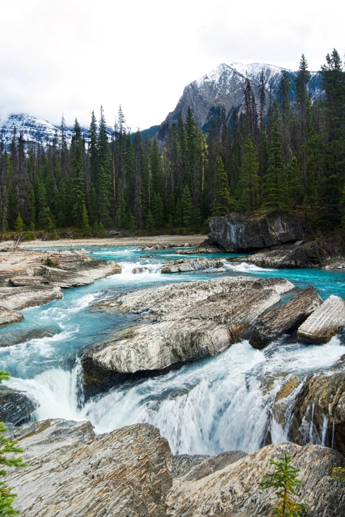
Natural Bridge
Natural Bridge
The Natural Bridge is right on the Emerald Lake Road so stop off on the way down to the Trans Canada Highway. Don’t try the antics of this tourist that I photographed leaping over the gap. He was trying out for the Darwin Awards.
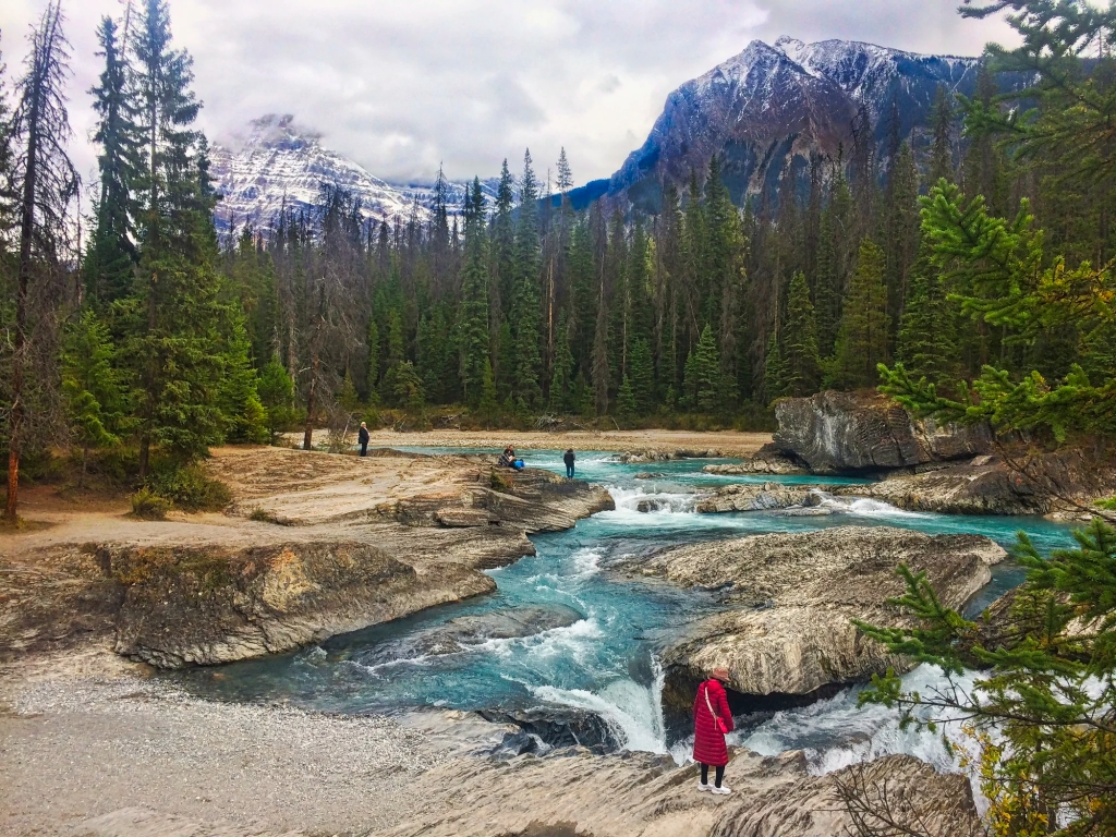
Kicking Horse River
Walk upstream for views of the glacial green river that originates from glaciers on the continental divide. In 1858,James Hector was kicked by his horse attempting to cross the swift-flowing waters of this river. Hector named it the Kicking Horse River.
One of BC’s best coffee roasters is named Kicking Horse Coffee. Located in Invermere at the western edge of the Rocky Mountains, their beans are now exported across the country .
Spiral Tunnels Viewpoint
The Spiral Tunnels, considered an engineering feat, were completed in 1909. It consists of two enormous loops tunnelled through the mountains allowing the desired 2.2% gradient, the typical standard.
The Spiral Tunnels Viewpoint is on the westbound side of the Trans Canada Highway, about five miles east of the town of Field. The original railway travelled down a dangerous 1,000-foot descent called the Big Hill that caused accidents.
To complete the CPR route as quickly as possible, a decision was made to not blast a lengthy tunnel through Mount Stephen. Instead a steep 13 km line with a 4.5% grade was built in 1884. The first construction train to go down the pass ran off the hill landing in the Kicking Horse River. The rail line was also subject to avalanches and landslides. The village of Field was created solely to add locomotives to trains about to tackle the Big Hill.
It’s not the most scenic viewpoint unless a train happens to come by. But it’s worth the stop for its historical significance. The railway was a condition for British Columbia joining Canada rather then the United States. Yes, that was a possibility! This was caused by the influx of American gold prospectors during the Cariboo Gold Rush as described in the post, Barkerville, the Town that Changed the History of Canada.
About 1000 people worked on the Spiral Tunnels for three years at the cost of about $1.5 million in 1909 or $50.4 million in today’s dollars. Wages were much lower then.
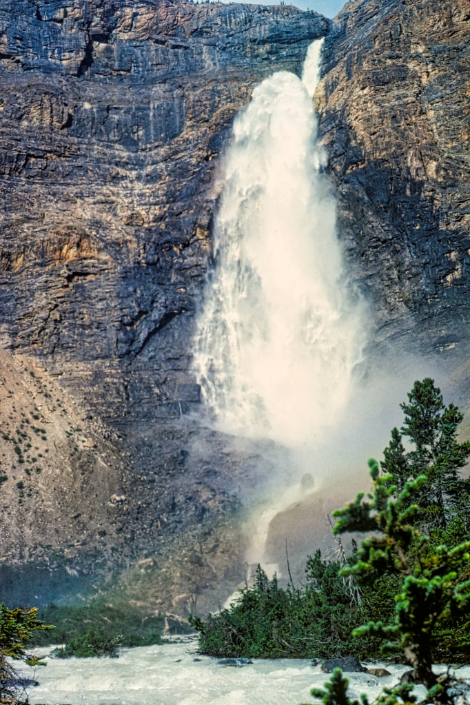
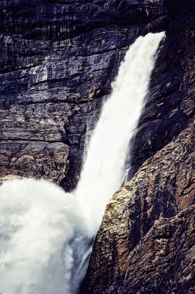
Takakkaw Falls
The Yoho Valley road is narrow and winding, with a series of scary 270’ switchbacks. Camper vans and trailers are not allowed. On the way up is a minor stop Meeting of the Waters where the Yoho and Kicking Horse Rivers merge. The cloudy Yoho and clear Kicking Horse are both glacier fed but the size of the silt suspended in the water affects the colour.
From the falls parking lot, cross the bridge over the Yoho River and take the trail to the bottom of the falls.
Total Takakkaw Falls
We suggest you come here after Emerald Lake as there is better sunlight for photos of the falls in the afternoon. Takakkaw Falls faces west.
Upper Takakkaw Falls Zoom Lens
Takakkaw is a Cree word meaning “magnificent”. Indigenous names are far more descriptive than the European names. In fact, the cardinal rule in place names is that the original explorer gets to assign the name. We should therefore be using the Indigenous names. These magnificent falls are the second highest in Canada. They plunges over a sheer wall of rock more than 366 m (1200 ft) to the bottom.
Fun Fact: so what is the tallest waterfall in Canada? It is Della Falls, the 16th-highest falls in the world with a 440 m (1444 ft) drop. It is located on Vancouver Island, BC.
Takakkaw Falls Catapult
After pounding onto a ledge part way down, Takakkaw catapults in a free fall for 259 m (850 ft). The waterfall is fed by the Daly Glacier at the top, and is at its best in July. However, to us it was always a thundering falls feeding the Yoho River, a major tributary of the Kicking Horse River.
If you have time, return back to Lake Louise by the quieter original road now labelled Highway 1A to the Great Divide viewpoint.
Twin Falls Trail
We only did a small part of the Twin Falls Trail that heads upstream along the Yoho River north from the parking lot. It reaches Laughing Falls after 4.7 km, which is a good destination for a short hike.
Twin Falls Trail is the return route for the Highline loop trail, which joins it at Laughing Falls. One web site claims it’s the best hiking trail in the Rockies, which is confirmed by the Canadian Rockies Trail Guide book. Highline was constructed at high altitude thanks to a request to the CPR by British climber, Edward Whymper. Whymper, the first person to climb the Matterhorn, came to Yoho NP in 1901.
Twin Falls Trail: 8.5 km 3 hrs OW; gain 290 m (950 ft), elevation 1800 m (5900 ft);
Highline or Iceline Trail: 24.4 km 1.5-2 days OW; gain 840 m (2750 ft), elevation 2090 m (6850 ft);
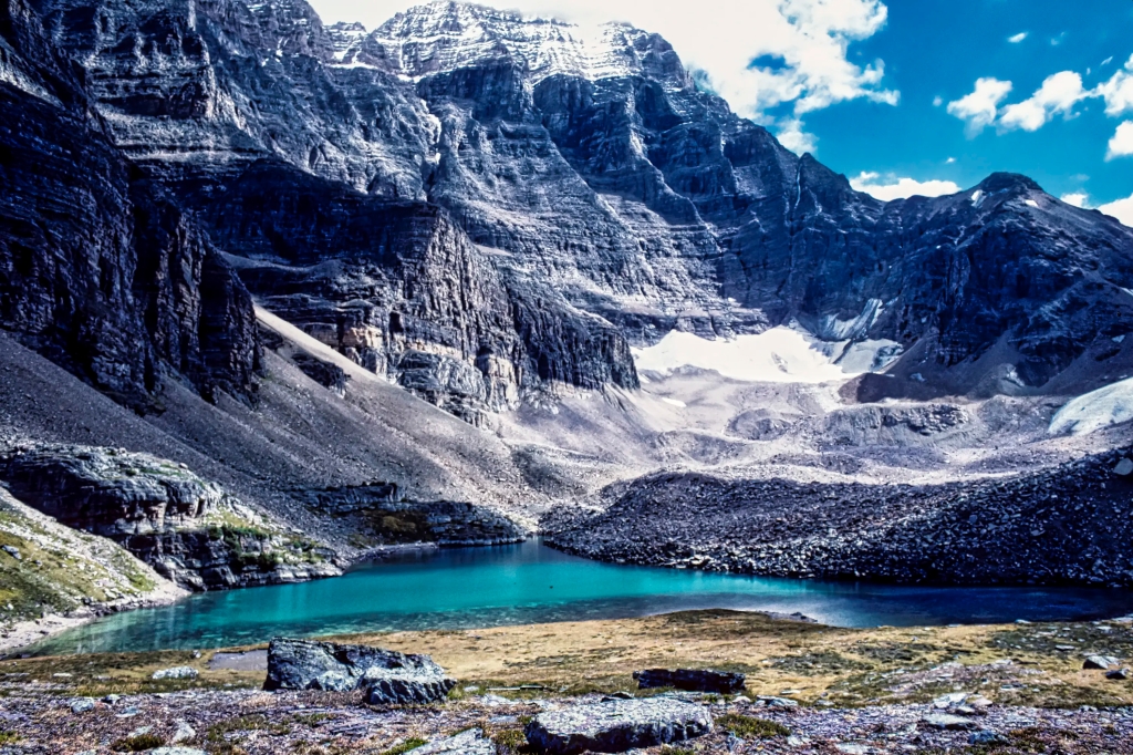
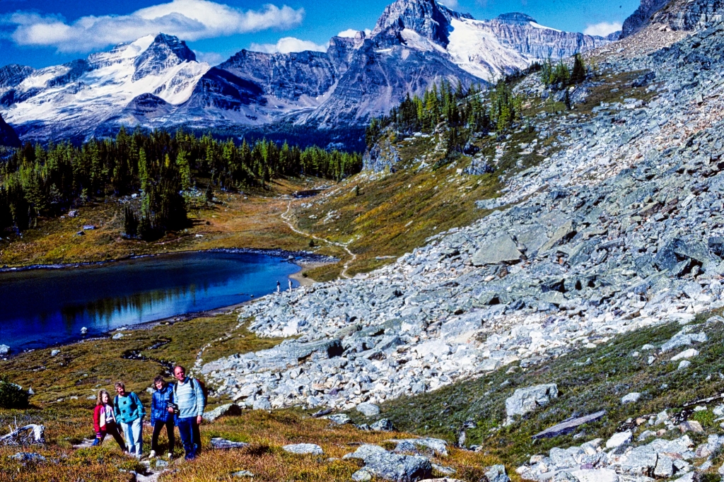
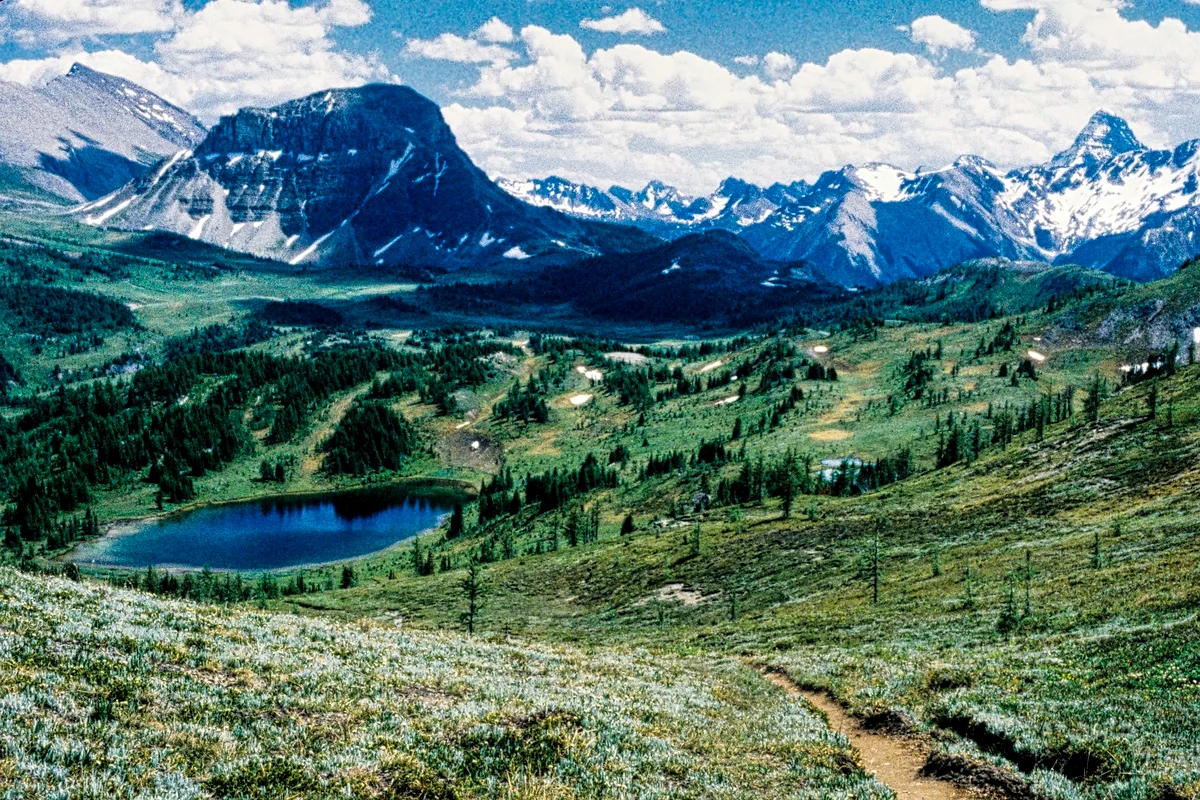
Lake O’Hara
Lake O’Hara from Opabin Plateau Trail
Lake O’Hara, located at 2020 m (6,630 ft) asl, is spectacular as well as peaceful. The area is named after Lieutenant-Colonel Robert O’Hara, from Galway, Ireland who served in Newfoundland. He did not discover this area but was probably the first tourist.
There are much less tourists compared to lakes like Moraine and Louise. In fact, we met no other people during the whole day once we left the Le Relais shuttle bus stop. This is because unless you bike or hike the 11 km restricted access road, you need to make advanced registration to travel on the shuttle bus. Most distant tourists do not know this and this makes access impossible to obtain seats at the last minute. The logistics are discussed below in the Where to Go in Yoho NP section.
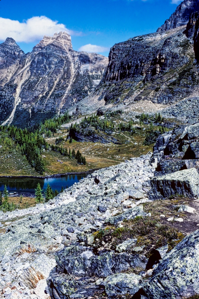
Opabin Plateau Trail
The Opabin Plateau Trail is a moderately challenging climb of 407 m (1335 ft) through scree and rocky terrain. The All Trails web site states it is a 3 hour, 8.7 km loop trail. However, because we were guiding our Kiwi friends and their two teen daughters, we shortened the route. We did not go north and walk all around the east side of Lake O’Hara. We headed south along the west shore and then climbed up to join the East Opabin trail.
Because the trail goes into the alpine there are wide open views of the mountains.
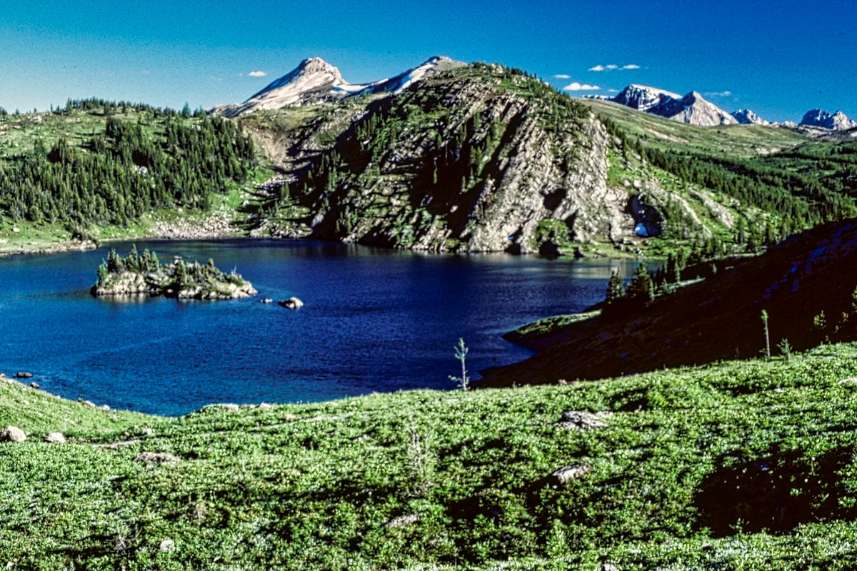
Lake O’Hara and Wiwaxy Peaks
Wiwaxy is the Stoney First Nations word for windy. Wiwaxy Peaks (2706m 8878 ft) are composed of sedimentary rock laid down during the Precambrian period. It’s hard to believe these date back to the earliest period of the history of Earth.
Wiwaxy Peaks from Cascade Lakes
Higher up, Hungabee Lake and Cascade Lakes are sprinkled along the trail. The upper portion of the Wiwaxy Peaks are reflected in the lake.
Opabin Lake (2277 m 7470 ft) is the major feature on the Opabin Plateau, a hanging valley located above Lake O’Hara.
Kiwi Family on Cascade Lakes to Opabin Lake climb
We descended on the West Opabin Trail. There is a side trail to Opabin Prospect, an amazing panorama of Lake O’Hara and the surrounding mountains. This is the iconic viewpoint of Lake O’Hara. As we were guiding our Kiwi friends and their two teenage daughters, we did not do this special side trail. The daughters were more interested in going shopping at West Edmonton Mall in Edmonton.
Opabin Plateau Trail: 5.9 km 3 hrs loop RT; gain 407 m (1335 ft), elevation 2270 m (7448 ft);
Lake O’Hara from Shoreline Trail
On the way back, we joined with the Lake O’Hara ShorelineTrail, which is ideal for non-hikers who want to experience amazing mountain scenery.
Mt Victoria & Mt Lefroy behind Lake O’Hara
Mt Victoria (3464 m 11,365 ft) is the West Side Story of the famous mountain that frames Lake Louise. Mount Victoria is composed of sedimentary rock laid down during the Cambrian period. To the right, Mt Lefroy (3423 m 11,230 ft) was the subject of a prominent painting by Canadian Group of 7 artist Lawren Harris.
Lake O’Hara Shoreline or Adeline Link Trail: 2.8 km 1 hr loop RT; gain 54 m, elevation 2270 m (7448 ft)
Lake O’Hara Alpine Circuit is an all day hike to Wiwaxy Peaks, Mt. Huber, Lake Oesa, Hungabee Lake, and All Soul’s Prospect. It’s one of the more difficult options.
Lake O’Hara Alpine Circuit Trail: 11.1 km 5 hrs loop RT; gain 887 m (2910 ft)
What to Wear in the Canadian Rockies
If you go to Lake O’Hara, you are going to be totally isolated so food, clothing, and equipment you carry with you are important. In fact, whenever you are hiking in the mountains, you need to bring layers of clothing as weather in the alpine can vary from sunny to wintry in one day due to the altitude. It snowed on us in Kootenay NP in July! We always use hiking boots, hiking or sports socks, a Patagonia, and a Gortex jacket. Also bring a pair of gloves in case you experience cold weather. Do not forget a water bottle. We always wore a day pack to carry the unused layers of clothing and camera equipment,
What Wildlife can I See in the Rockies?
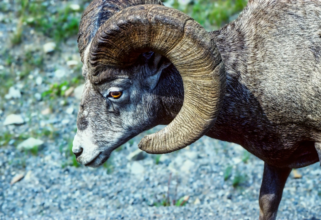
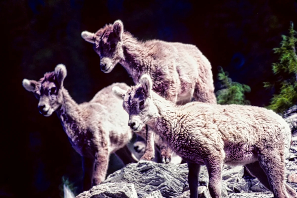
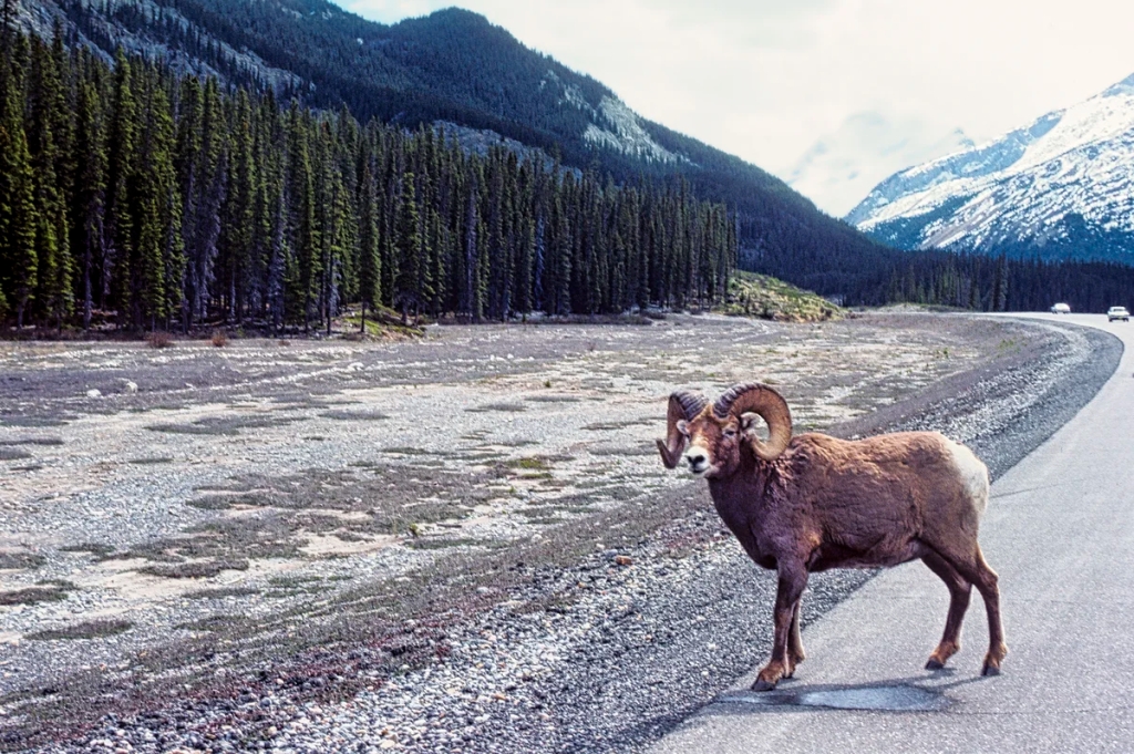
Bighorn Sheep
To see wildlife, you probably need to go searching in early morning or late afternoon/evening. Note that sunset is at 22:00 hrs in June!
The animals most people want to see are Bighorn Sheep, Mountain Goats, Bears, Moose, Deer, and Wapiti. There are two other animals that we most identify with the Rocky Mountains. The can only be seen by hiking. The marmot lives in ground boroughs or rock slides near timberline. They are often seen getting a suntan. The big-eared, tiny pika lives in sub-alpine or alpine rock slides.
What Wildflowers can I See in the Rockies?
The flowers of the Canadian Rockies can be found on many subalpine and alpine hikes. You just need some sunlit areas. The issue is not where but when. Because of the high altitude, the best time for wildflowers depends on when the snow has melted. Sometimes this can be late June; sometimes late July. This means you usually need to go hiking in July-August.
Columbine, Subalpine Wildflower
Columbine is a beautiful wildflower in Banff NP. It is found in subalpine forests and is common in early summer.
Where to Eat in Yoho NP
Dining out is very limited in Yoho NP. There is no nearby town. The options are limited to the poorly rated Cilantro Café (Google rating 3.4) at Emerald Lake and the highly rated Truffle Pigs Bistro (4.5) and The Siding Café (4.6) in the village of Field. Google ratings are based on the opinions of all people not just tourists. Any rating between 4.0 and 4.4 is Very Good (VG) and ≥ 4.4 out of 5 is Excellent (E). See locations on our custom BC Yoho & Glacier NPs Itinerary Map.
Le Relais on Lake O’Hara has snacks and supposedly the best carrot cake ($6 but bring cash).
Usually we bring our own food to Yoho and have a picnic. We always buy non-perishable food (cans) and some fruits and vegetables in Edmonton/Calgary and fill up on gas before hitting the more expensive Rockies. We store our food in old milk delivery crates or our plug-in cooler in our van. We never put aromatic fresh food in our backpacks due to the bears. Don’t forget light-weight backpacking cutlery.
Where to Stay in Yoho NP
Yoho NP has Kicking Horse Campground (Google 4.2, tent sites $29.25) and Monarch Campground (Google 3.5, primitive sites $18.75).
For Lake O’Hara, there are only two options: Lake O’Hara Lodge (Google 4.3, $860 (ouch) for a double full board) and Lake O’Hara Campground with 30 sites for a maximum stay of 3 nights (Google 5.0, backcountry sites $12.75 per person).
There are a few rooms available at about 12 guesthouses in Field. You can find their contact number and booking web site on Google maps. This is a small village of only 195 people so there are not many options. All villages and towns in the Rockies are all owned by Parks Canada and cannot just expand.
Generally, we stay at a base in Lake Louise Village and commute to Yoho. Another alternative would be the town of Golden, BC, which we researched for our last trip. Golden has several VG-rated places like Best Western, Canyon Ridge Lodge, Pinewood Inn, Kicking Horse Guest House, Rooms at Riveredge, Brookside Motel, and Dreamcatcher Hostel. Many of the other hotels have very poor ratings.
What to Read about the Rockies
The two books should be available in any bookstore in Alberta and are on Amazon.
Parkways of the Canadian Rockies(Brian Patton 2008, CAD 24.47) is like bringing a naturalist along to interpret what you should be seeing.
Canadian Rockies Trail Guide(Brian Patton & Bart Robinson 2022, CAD 29.95) is the best hiking book we have seen or used in all our travels around the world.
Since the Trans-Canada goes through Yoho NP, you can transit through the park without any fees. But the minute you park, hike, drive on the side roads, or do some other activity — you must have a NP pass. The day pass is $10.50 per person. The annual Discovery Pass is $72.25 for all 80 Parks Canada sites. There are no multi-day passes. There are discounts for children and seniors.
Lake O’Hara Shuttle Bus
Lake O’Hara requires reservations because access is restricted to park shuttle buses. These are extremely difficult to obtain unless you log into the Lake O’Hara reservations system when it opens; e.g. at 8:00 MT, April 12, 2023. You will be added to the queue and will be able to book whatever time slots and days remain when you get to the front of the virtual queue.
The shuttle bus drives 11 km to Lake O’Hara and costs $17.14 return per person. It operates from ca. June 18 to October 3. Day-use bus schedule ingoing: 8:30 and 10:30 and outgoing: 9:30, 11:30, 14:30, 16:30, and 18:30 (MT). The only alternative is to hike 11 km OW on the road.
Where to Go Next
This post is one of four itineraries for the Canadian Rockies. S/he who goes to the Canadian Rockies and does not drive the Icefield Parkway has missed THE quintessential road trip in all of Canada.
Barkerville is an off-the-beaten track area northwest of Yoho NP but there is no direct road. From Emerald Lake you will need to drive 861 km 9:33 hrs. via Kamloops to get there. However, if you visit Glacier NP in BC then you will have already done 149 km 2 hrs. To see this route, unhide the Golden to Barkerville driving layer on the custom BC Yoho & Glacier NPs Itinerary Map.
Our recommendations are not influenced by affiliate links – we have none. Our content and advice is derived from our personal expertise, experience, and knowledge based on living in Alberta for ten years. All the places recommended in this post are pinned on ourRocky Mountain Itinerary Map. The place names are appended with the Google Maps Rating (G0 to G5).
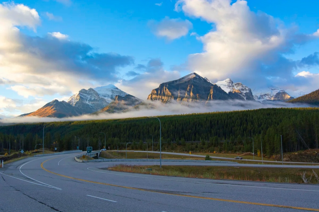
Why You Should Do the Icefield Parkway Drive
Early Morning at Entrance to Icefield Parkway
The Icefield Parkway is the name given to the spectacular, glacier-lined Highway 93N between Lake Louise village and the town of Jasper. For snowy sierras, gorgeous glaciers, exciting hiking trails, and spectacular turquoise lakes — it is hard to beat the Icefield Parkway itinerary.
Should I See Banff or Jasper NP?
One recurrent question is “what are the best places to visit in the Rocky Mountains?” Unfortunately, there are too many tourists thinking that Banff the town and Lake Louise are the ultimate destinations of the Rockies — they are not! They have been spoiled by over tourism, bus-only roads, plus difficult and expensive parking. Moreover, since the Trans-Canada Highway is now a fenced expressway, there are no more animal sightings along this highway, which is better for the animals.
Another frequent question is “if I do not have much time, should I visit Banff or Jasper National Park (NP)?” Our recommendation is that you should see BOTH! What, how is that possible?
You can see the best parts of Banff and Jasper NPs by driving the Icefield Parkway. The road from Lake Louise village to the town of Jasper is THE Quintessential Road Trip of Canada, if not North America.
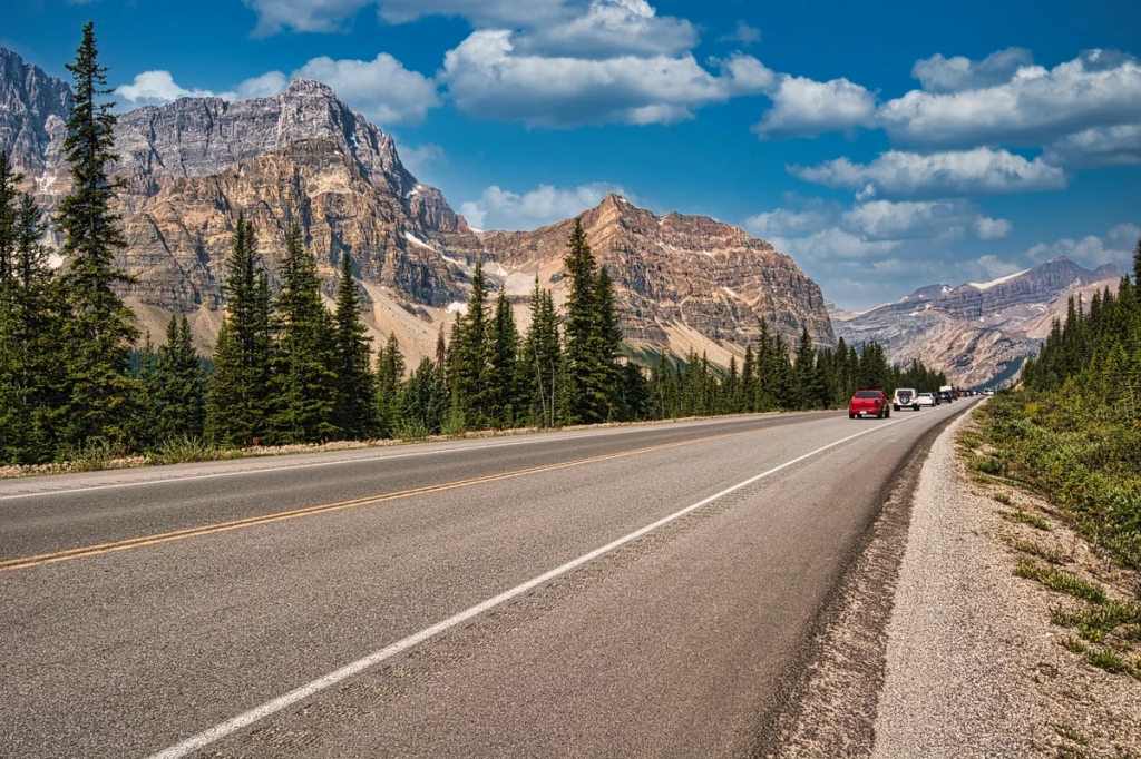
Icefield Parkway is the Best Road Trip
Icefield Parkway South
The Icefield Parkwayprovides 232 km of easy access to rugged Rockies, gorgeous glaciers and vast vistas — all from the luxury of your car. There are not many roads in North America that are this spectacular for this long a distance with minimal human development and commercialization.
For instance the Going to the Sun road in Montana is only 80 km and requires a reservation. The Sea to Sky Highway is 163 km. While it has spectacular moments, most of the sights require getting off the highway, hiking or taking gondolas.
If you just go to Banff and Lake Louise and skip the Icefields Parkway, then you have missed the essence of the Rockies.
Glacier near Icefield Discovery Centre
The most special aspect of the Canadian Rockies are the glaciers (while they last), the gorgeous turquoise lakes and rivers they created, the rock flour (yes it’s a real thing), and 3400 km of superb hiking trails. These are the key features of the Quintessential Canadian Rockies.
The Columbia Icefield is not only the largest south of the Arctic Circle but the most accessible. A little known fact is that the Jasper Dark Sky Preserve is the largest accessible Dark Sky Preserve in the world. This means it’s a great place for stargazing.
Parker’s Ridge Trail
Yes, you can easily drive the road in one very full day. But to get the most out of your trip, you need to get out of your car and spend some time enjoying the hikes and sights. If you only have a few days in the Rockies, we would highly recommend that you spend all of them along this road. You can commute from your base up and down the Parkway.
Best Places to See on the Icefield Parkway
Our advice is not based on a single tourist trip. Our recommendations are based on our extensive experience living in Alberta for ten years. We are avid hikers, nature lovers and photographers (all photos are my own). The Rocky Mountains were our weekend playground as well as vacation destination.
Since most tourists are on a short visit, we are highlighting only our favourite viewpoints. We are also not going to include places like Lake Agnes, Valley of the Five Lakes, or Canmore. Instead, this itinerary focuses on what makes the Quintessential Rockies in a very compact geographical area.
The first stop is only 2.7 km (1.7 mi) from the start of the Icefield Parkway. Herbert Lake is not a must-see as the mountains appear to be far away and thus it lacks a dramatic backdrop. But the beautiful reflections and crystal-clear water make up for the lack of saturated turquoise colour.
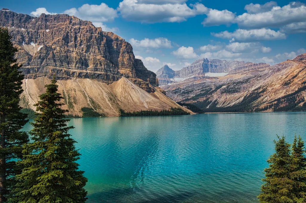
Bow Lake
Bow Lake Looking Northwest
This view is a major pull-off on the west side of the Parkway about 32 km (19.9 mi) further. You are now driving in the subalpine at an altitude of 1920 m (6300 ft). Bow Lake is one of the top five turquoise lakes in the Rockies. As we stated in 15 Things you Must Do in Banff and Lake Louise, we do not include Lake Louise in the top five as it has been spoiled by excessive crowds of tourists.
Crowfoot Glacier, Bow Lake Looking South
Bow Lake comes with a dramatic backdrop of Crowfoot Glacier clinging to the steep cliffs of Crowfoot Mountain. This view is actually 1.4 km (0.9 mi) south (before) the Bow Lake pull-off.
To the northwest are Mt. Jimmy Simpson (right), Mt. Thompson (left), and Bow Glacier (not visible). These are best viewed from the red-roofed Num-ti-jah Lodge on a side road at the end of the lake. There is a very pleasant lakeside walk behind the lodge. One can continue 4.3 km (2.7 mi) further to the foot of Bow Glacier.
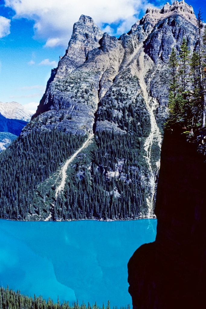
Peyto Lake
Peyto Lake when there were no tourists
From the Bow Lake pull-off, drive 6.3 km (3.9 mi) to a side road up to Bow Summit at an altitude of 2069 m (6787 ft) – one of the highest points on the Parkway. Peyto Lake is one of the top five turquoise lakes in the Rockies. It requires a short hike that most people should be able to do. Going to the Rockies and missing Peyto Lake is like going to Rome and missing the Pantheon!
Imagine when there was only the train travelling through the Rockies. You got off at Lake Louise and met the first tourist guide in the Rockies, Bill Peyto. You rode horse-back for 48 km until you got to this gorgeous lake, which became known as Peyto’s Lake!
Today you drive an easy 38 minutes. There is disabled parking at the top of Bow Summit. Everyone else has to walk uphill for 20 minutes.
At the top, many of the tourists ignored the railing to get that “perfect shot”. Actually, the viewing platform is just as good a place – except when people get into the view.
Why are the Lakes Turquoise?
Peyto Lake with some tourists
Glaciers can be around 600 m (2000 ft) thick and they flow downhill — yes, they flow like a river of ice. Glaciers grind rocks below them creating well-named rock flour — it is so fine that when the sediment in the meltwater hits a glacial lake it hangs in suspension throughout the water. The rock flour absorbs all colours of the spectrum but reflects back green-blue. This gives all glacial lakes and rivers around the world a spectacular turquoise colour. If you cannot believe in rock flour, go to the Icefield Visitors Centre to see some.
What Flowers can you See in the Rockies?
Hiking trails such as Peyto Lake are the best place to see wildflowers during the summer – generally mid-July to August. Additional flowers you can see are described in 15 Things you Must Do in Banff and Lake Louise.
Grass of Parnassus, alpine flowers of the Rockies
The five petaled Grass of Parnassus is an alpine flower named after a mountain in Greece.
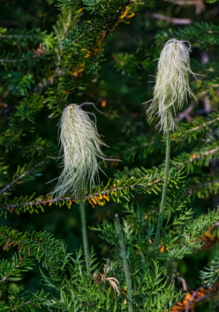
Western anemones, alpine flowers of the Rockies
Within days after snowmelt, the white Western anemones start to flower. For this reason, during the summer we usually see this alpine flower as a shaggy seed head, which is shown in the photo. The fresh stems and seeds of this plant were used traditionally as analgesics and sedatives.
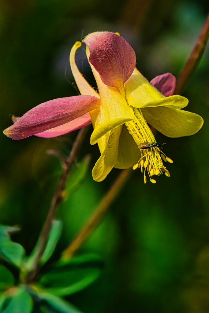
Columbine, woodland and alpine flowers of the Rockies
Columbine is a beautiful and quintessential wildflower in Banff NP. It is found in subalpine forests (and in our garden) and is common in early summer.
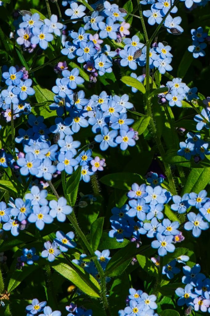
Alpine Forget-me-not, alpine flowers of the Rockies
The Alpine Forget-me-not is a powder blue flower common to the Rockies. As it grows at elevations between 7,500 to 10,000 feet, it’s growing season is limited to June-September.
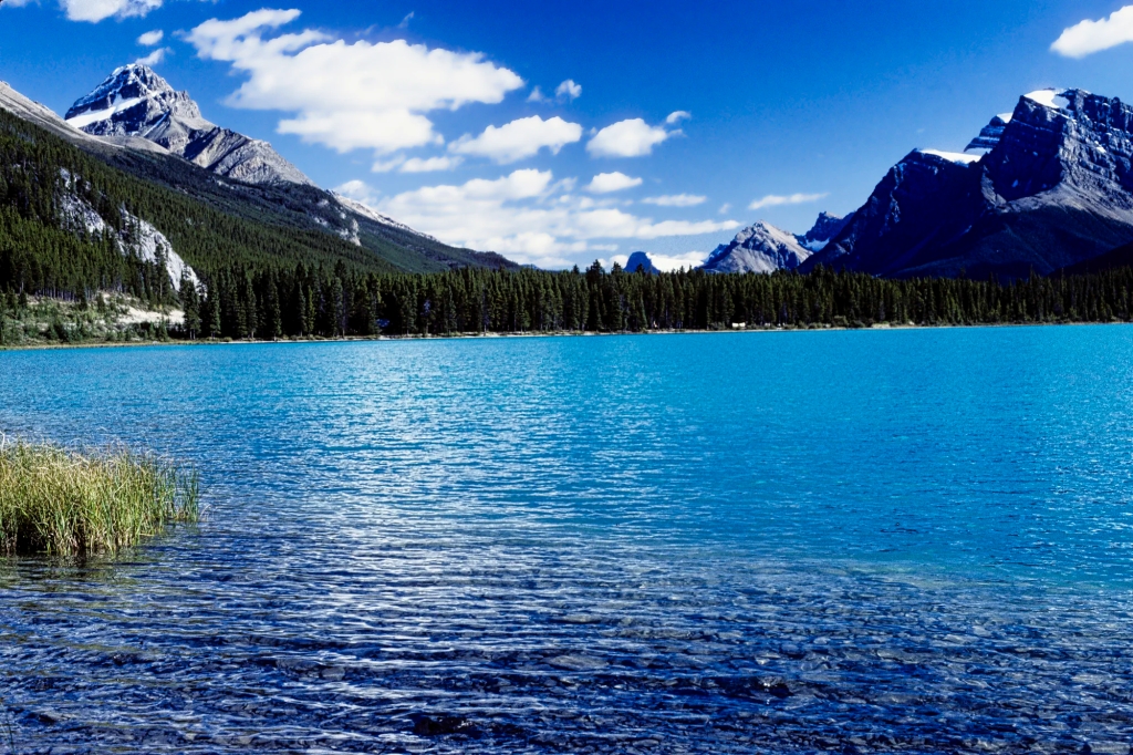
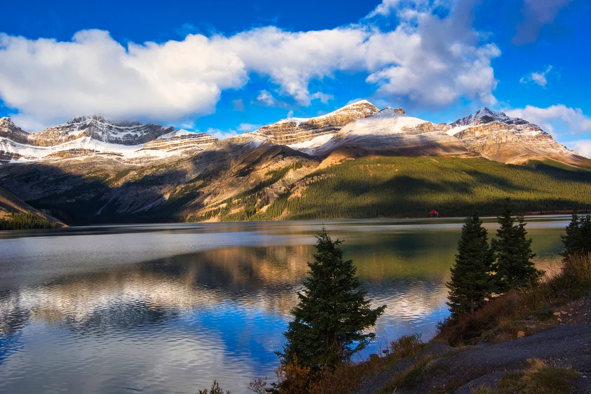
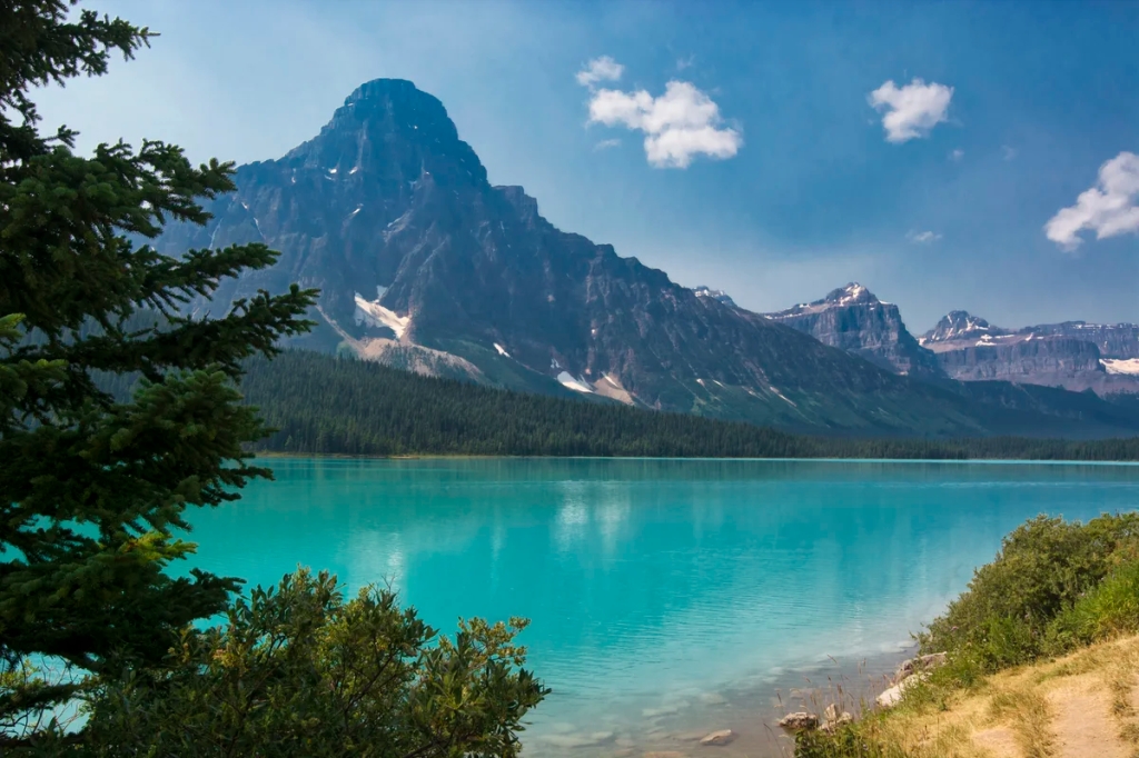
Waterfowl Lakes
Mt. Chephren behind Waterfowl Lake
We prefer the views of Waterfowl Lake from the Waterfowl Lakes Campground, 17 km (10.6 mi) north of the Bow Summit turn-off. It is a great camping location but you must bring food with you as there are no stores.
From here you can take a 4 km trail to Chephren Lake at the base of pyramidal Mt Chephren (pronounced “kefren”) in the photo. It was named after one of the great pyramids in Egypt.
Mt. Patterson from the Upper Waterfowl Lake
This view of Mt. Patterson was taken from the Upper Waterfowl Lake.
Mt. Wilson
Mt. Wilson unmarked viewpoint
We must have passed this view a million times but never took a picture here. The magical, softer autumn lighting (October) must have attracted us to stop. This unmarked viewpoint is on the west side of the road before the Parkway descends down to Saskatchewan River Crossing, the junction with Highway 11.
Mistaya Canyon
The Mistaya Canyon Trail is an easy 0.5 km 15 minutes (one way) canyon walk. Mistaya is Cree for grizzly bear. This slot canyon features eroded potholes and limestone walls. Limestone is somewhat soluble by water.
The Mistaya Canyon parking lot is on the west side of the Icefields Parkway, 14 km north of Waterfowl Lakes or 5.2 km south of the David Thompson Highway junction.
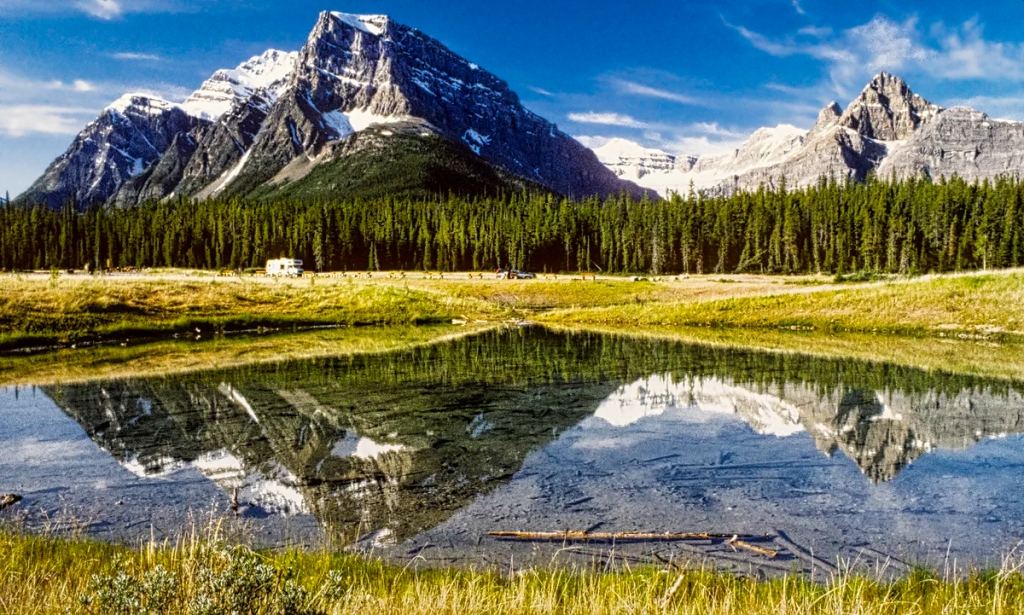
Great Bend
Cirrus Mountain from Big Bend Lookout
Located 36.4 km (22.6 mi) north of the David Thompson Highway junction, the viewpoint at the top of the “Big Bend” is definitely worth a stop. You have an airplane view from 427 m (1400 ft) above the valley floor. Directly ahead is Cirrus, a 3,270-metre (10,730-foot) mountain.
Notice that the limestone strata of Cirrus Mountain are bent into a huge upward curve. The Castle Mountain Syncline extends from the town of Banff to the town of Jasper! It is amazing to realize that these layers were once flat and below an ocean. This syncline or upward folding of the rock layers was caused by massive tectonic forces. Even more amazing was that this tectonic force was the Pacific Plate crashing into the North American plate that uplifted all the mountains including the Rockies ca. 65 million years ago. Soon after the Great Extinction Event wiped out the dinosaurs and ended the Cretaceous Period.
Parker’s Ridge
October Snow on Hilda Peak, Banff NP
Driving the Icefield Parkway in the fall is magical with lots of snow on the high altitude peaks and a dusting of snow on the lower altitude slopes. PS.: You need winter clothing if you visit the Icefield Parkway in the fall. Because of the altitude, this region has a sub-arctic climate.
Hilda Peak, near Parker’s Ridge, Banff NP
Here is a close-up view of Hilda Peak, located at the Banff NP northern boundary. It consists of 3058 m (10,033 ft) of Jurassic Period sedimentary rock.
Parker’s Ridge on lower left; Mt. Athabasca in centre
After a 5.3 km (3.3 mi) drive from the Big Bend, we have reached the Parker’s Ridge trail head but there is too much snow to hike up in early October.
North Saskatchewan Glacier, Parker’s Ridge Trail
Parker’s Ridge is one of our all-time favourite hikes to take visitors in the Rockies. It is a very steep climb over a short distance. In only 45 minutes you reach the top, an alpine area with breathtaking 360° views. Would you believe that the typical low-lying shrubs are actually stunted trees?
At the end you will be spell-bound by the quintessential 13 km Saskatchewan Glacier spreading below you. It feels like you are an eagle. If you are lucky you will see mountains goats along the mountain slopes.
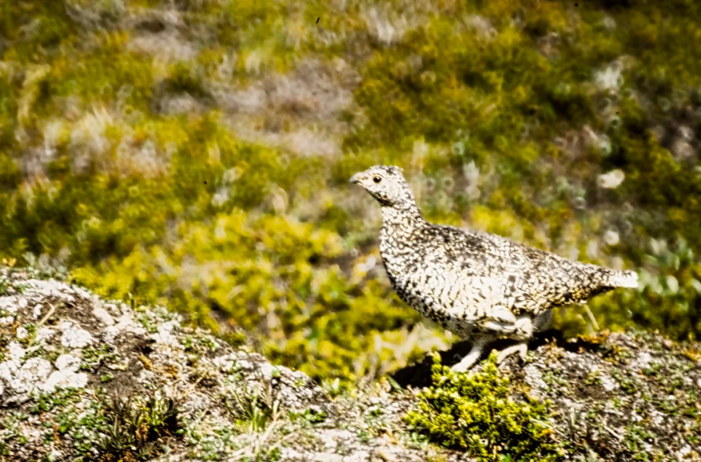
White-tailed ptarmigan, Parker’s Ridge Trail
If you have been very good this year, you may see a White-tailed ptarmigan. These birds are amazingly camouflaged with the rocky terrain they walk around. In fact, before I darkened the background it was very difficult to see the ptarmigan.
Parker’s Ridge Trail: Distance: 2.4 km 0:45 hrs OW 2.5 hrs RT; Elevation: 2270 m (7450 ft); gain 275 m (900 ft),
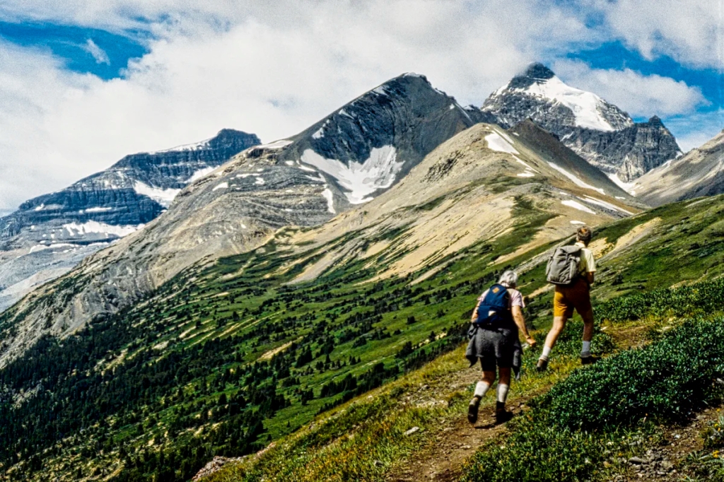
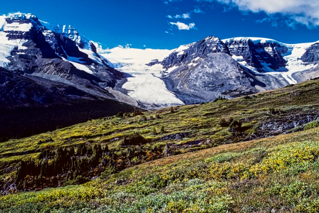
Wilcox Pass Hike
Athabasca Glacier from Wilcox Pass Trail
This five-star hike starts near the entrance of the Wilcox Creek campground in Jasper National Park. It rises quickly above treeline to the expansive meadows of this glacier-carved landscape. In fact, you don’t have to do the whole trail to see incredible views of the Columbia Icefield and surrounding mountains.
Wilcox Pass Trail: Distance: 4 km 0:45 hrs OW 3.5 hrs RT; Elevation: 2270 m (7450 ft); gain 335 m (900 ft),
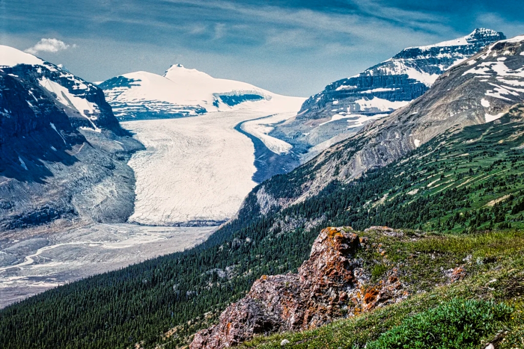
Columbia Icefield
Mt. Athabasca on left and Athabasca Glacier
The Icefield Parkway was named for the Columbia Icefield. The road was opened in 1941 but was only modernized and paved in 1961!
The Columbia Icefield is the largest uninterrupted glacial mass in the Rockies. You cannot actually see the icefield, which is in the “bowl” on the other side of the Athabasca Glacier in the picture above. The icefield is about the area of Omaha NE and up to 365 m (1198 ft) deep!
Go to the main parking lot for the Columbia Icefield Discovery Centre (DC). There are several things to do here. The boardwalk to the DC on the west side of the parking lot offers many good viewpoints and photo opportunities. With a zoom lens or binoculars you can see closeups of the glacier and the mountains. Inside the DC there was an exhibit to show you what rock flour feels like
On top of Athabasca Glacier
The Columbia Icefield Adventure includes a glacier bus and the glass Skywalk. You need to park at a separate parking lot for this tour.
The bus drove on top of the glacier where we saw a crevice. The interpreter reminded us about the dangers of walking on ice. We also learned that we were looking at an ice fall, a waterfall of ice. Glaciers can flow downwards even over mountain sides.
We did the glacier bus when it was quite reasonably priced. Today, prices vary by date from CAD 97 to 134 per adult. During peak high season, the prices are higher. The Columbia Icefield Skywalk is a short bus ride to a walk on a glass bridge and costs CAD 37.80.
Alternatively, you can park in the glacier parking lot below the DC and walk to the toe – due to crevasses it is dangerous to walk on any glacier.
What Wildlife can I See in the Rockies?
This next stretch of the Icefield Parkway provides a good chance of seeing wildlife in the Rockies but you have to work at it. Hiking, side roads, dusk and dawn increase the probability of seeing wildlife. You can see Rocky Mountain sheep, goats, marmots, coyote, wapiti, deer, pika, and bears if you are (un)lucky!
Many tourists used to get mauled by bears and even wapiti. The cardinal rule is never get too close to foraging wildlife. If they keep eating you are safe; if not you have gone too close.
Sunwapta Canyon Viewpoint
Stop at the Sunwapta Canyon Viewpoint, about 6 km (3.7 mi) north of the Columbia Icefields Centre. There is a glorious view of Mt Athabasca in the centre and Mt Andromeda on the right next to the hidden Columbia Glacier.
Many times we have seen a convention of bighorn sheep or mountain goats hanging out along the Parkway. This is due to a nearby salt lick on the canyon side of the road. Drive this road section slowly.
Tangle Falls
Tangle Falls
The 48 metre-tall Tangle Falls has a special look as it has four tiers with multiple cascades at the top. It is located ca. 7 km (4.3 mi) north of the Columbia Icefield Centre.
The falls are right on the east side of the Icefield Parkway so no hike is required. Parking is on the west side of the road, so be careful crossing the Parkway.
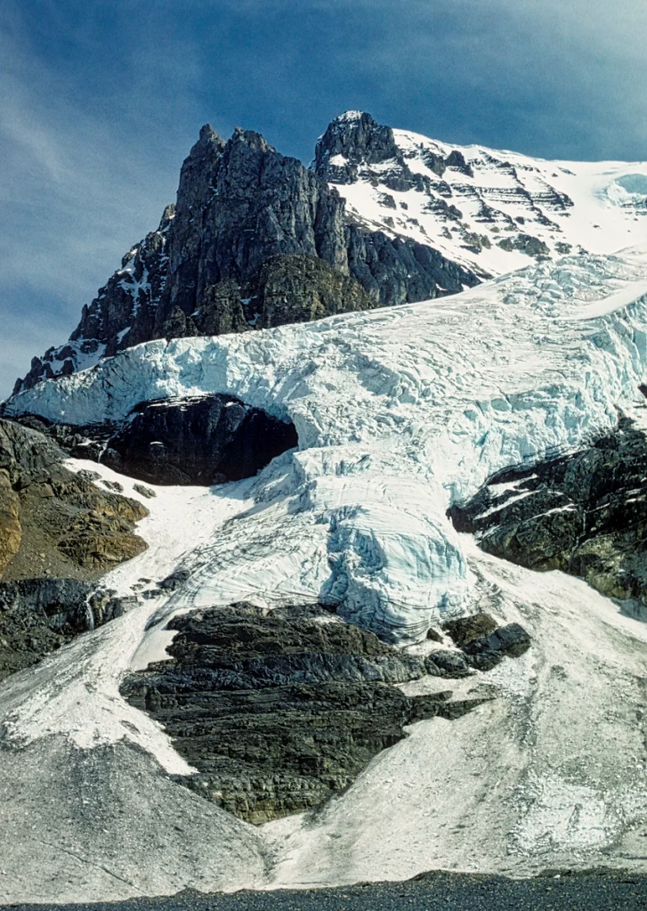
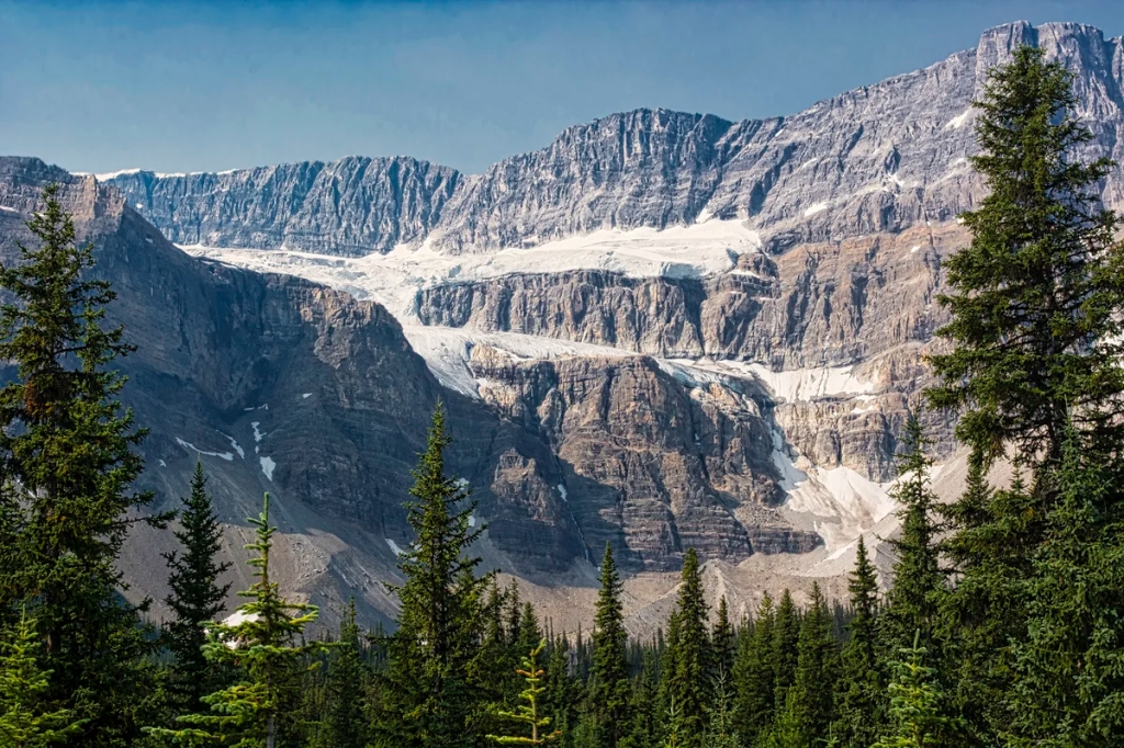
Stutfield Glacier Viewpoint
Stutfield Glacier
Just under two km (1.2 mi) further north is another spectacular viewpoint. Stutfield is one of the most picturesque glaciers originating from the Columbia Icefield. It seems to pour down a 914 m (3000 ft) cliff.
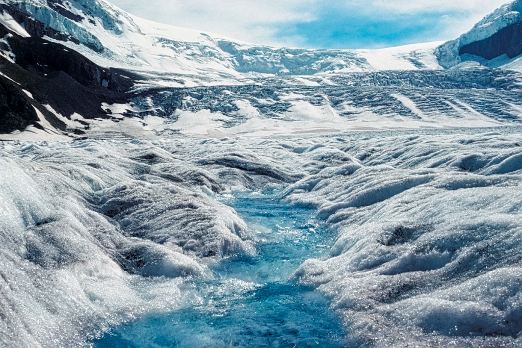
Victoria Ice Fall Zoomed In
To help you appreciate the thickness of a glacier here is a zoom view of the Victoria Ice Falls. You can feel the thickness of the ice.
So how does the glacier get down the mountain? It falls just like water. Once a glacier achieves ca. 50 m (164 ft) thickness, the pressure from its weight deforms the ice at the bottom. This process of plastic deformation occurs because the ice crystals can slowly bend and change shape without breaking or cracking. Glacier sliding is assisted by a thin layer of water at its base.
The hiking trail to the glacier requires fording the glacial water of the Sunwapta River. BTW, never drink glacial water! The rock flour will give you diarrhea. With that pleasant thought see you on our much more appetizing post, Jasper & Mt Robson – 7 Best Places to See. This continues our exploration of the Icefield Parkway and other side trips in the Jasper town area.
What to Read about the Rockies
The two books below should be available in a bookstore in Alberta and are on Amazon.
Parkways of the Canadian Rockies(Brian Patton 2008, CAD 24.47) is like bringing a naturalist along to interpret what you should be seeing.
Canadian Rockies Trail Guide(Brian Patton & Bart Robinson 2022, CAD 29.95) is the best hiking book we have seen or used in all our travels around the world.
Travel Tips page provides advice that applies to any trip (you can access via the Terra Encounters menu as well).
Where to Stay
Lake Louise has many hotels but they are very hard to come by and very expensive during high season — which is most of the year due to the excellent skiing. Our favourite places to set up base are the Lake Louise and Waterfowl Lakes Campgrounds. If those two are full there are other non-reservable campgrounds like Wilcox Creek and an overflow area near Lake Louise. Lake Louise and Waterfowl Lakes are much better locations to commute for the two must-see drives: Icefield Parkway (this post) and Yoho Valley (future post).
After touring the Icefield Parkway, you can stay in Jasper in order to visit the Athabasca Falls and Mt. Edith Cavell area covered in the next itinerary, Jasper & Mt Robson – 7 Best Places to See. Besides chalets, we have stayed at Whistler’s and Wabasso Campgrounds. The smaller Wabasso was our favourite.
Where to Go in Banff and Jasper NPs
To save you time we have designed a Rocky Mountain Itinerary Map with estimated distances and driving times. There are so many places to see that we have divided this road trip into separate itineraries (layers in the Google map). Some layers such as Accommodation, Food and other itineraries are initially hidden to keep the focus on the sights. We have include additional points of interest not described in these posts.
This short distance of the Icefield Parkway may give the false impression that you only need one day to see it all. If you plan to hike, take tours, and visit interpretive centres and programs, then you will need far more days. Together Banff and Jasper NPs (17,519 km2) are equivalent to the 78% of New Jersey or 58% of Belgium. Three days is the minimum for a Rockies 101 course. You need a two or three week vacation to get to know the Quintessential Rockies.
Parks Canada Passes
Since the Trans-Canada goes through Banff NP and the Yellowhead Highway 16 travels through Jasper NP, you can transit through the park without any fees. But the minute you park, hike, drive the Icefield Parkway, or do some other activity — you must have a NP pass. The day pass is $10.50 per person. The annual Discovery Pass is $72.25 for all 80 Parks Canada sites. There are no multi-day passes. There are discounts for children and seniors.
Where to Go Next
If you have even one more day, the best thing to do after the Icefield Parkway is to spend time in the Jasper area. This is covered by the following itinerary.
Do you want to see some of the best views, glacial green lakes, rugged mountains, and exciting hikes in Banff National Park (NP)? This post describes the drive between Banff (town) and Lake Louise as shown on our Rocky Mountain Itinerary Map. This is one of three itineraries for the Canadian Rockies.
Our recommendations are not based on a tourist trip. Our itineraries, photos, and recommendations are based on our extensive experience living in Alberta for ten years. We are avid hikers, nature lovers and photographers. The Rocky Mountains were our weekend playground as well as vacation destination.
Banff the town
View of Banff from Mt. Norquay
Banff is a nice mountain town with great cafes, restaurants, and a supermarket. It has great campgrounds — one of which is open in the winter — and lots of expensive hotels. However, there are also too many tourists thinking this is the ultimate destination of the Rockies.
Working as a Bus Tour Guide, Banff
A long time ago, my niece worked in Banff as an bus tour guide one summer. We drove to pick her up for the weekend. We met her flatmates and talked for a while. Then I said, “ok, time to go to the Rockies”. The girls were shocked and said but this is the Rockies. What I meant was Banff is not the Quintessential Rockies.
What to Do in Banff Town?
If you are not a hiker or do not have a car, there are some interesting places to see in the town area. After getting your tourist literature at the Banff Visitor Centre, walk south on Banff Ave. to fuel up with coffee and snacks. There are some nice buildings along the way. Stop on the bridge over the Bow River for some nice views.
Cascade Gardens in the Fall
Enter the gates at the park headquarters to the pretty Cascade Gardens. Where have all the flowers gone?
Pansies, Cascade Gardens
It is much prettier during the summer season.
Bow Falls
Continue south on Glen Ave. to the Bow Falls Viewpoint. Look northwest for a very beautiful view of the falls.
Bow River heading East to Calgary
Also look east for a view of the Bow River heading to Calgary.
Drive up Spray Ave. to the Banff Springs Hotel for its incredible interior and exterior. The Canadian Pacific Railway (CPR) was built to ensure that British Columbia joined Canada (rather than the United States) in 1871. However, the railroad led to conflicting land claims after the discovery of the Banff Hot Springs. The government decided to reject all the claims and create the first national park (NP) in Canada (third in the world) in 1885. The CPR later built the Banff Springs Hotel and Chateau Lake Louise to attract tourists using extensive advertising.
The Banff Upper Hot Springs are not at the hotel (adults $16.50, swimsuit and towels not included). There is a lower hot springs as well but drive up Sulphur Mountain to take a dip with a view. It’s an amazing feeling to come here in the winter. You can swim from the shower are right into the outside pool! No need to walk in the frigid outside air – you feel you have conquered the Cold. Water temperature in the pool is kept at circa 38°C (100°F).
Leave it to my friends and I (all swimming instructors) to start swimming laps on our very first visit. We landed in hot water, literally — expect to take a long nap very shortly afterwards!
What to Do Near Banff Town?
Big Horn Sheep
Go along the Minnewanka Scenic Drive to search for wildlife in the parking lot before a big turn of the road to the right over the earth-filled dam. We used to see Big Horn Sheep in the parking lot, especially when there are not too many people.
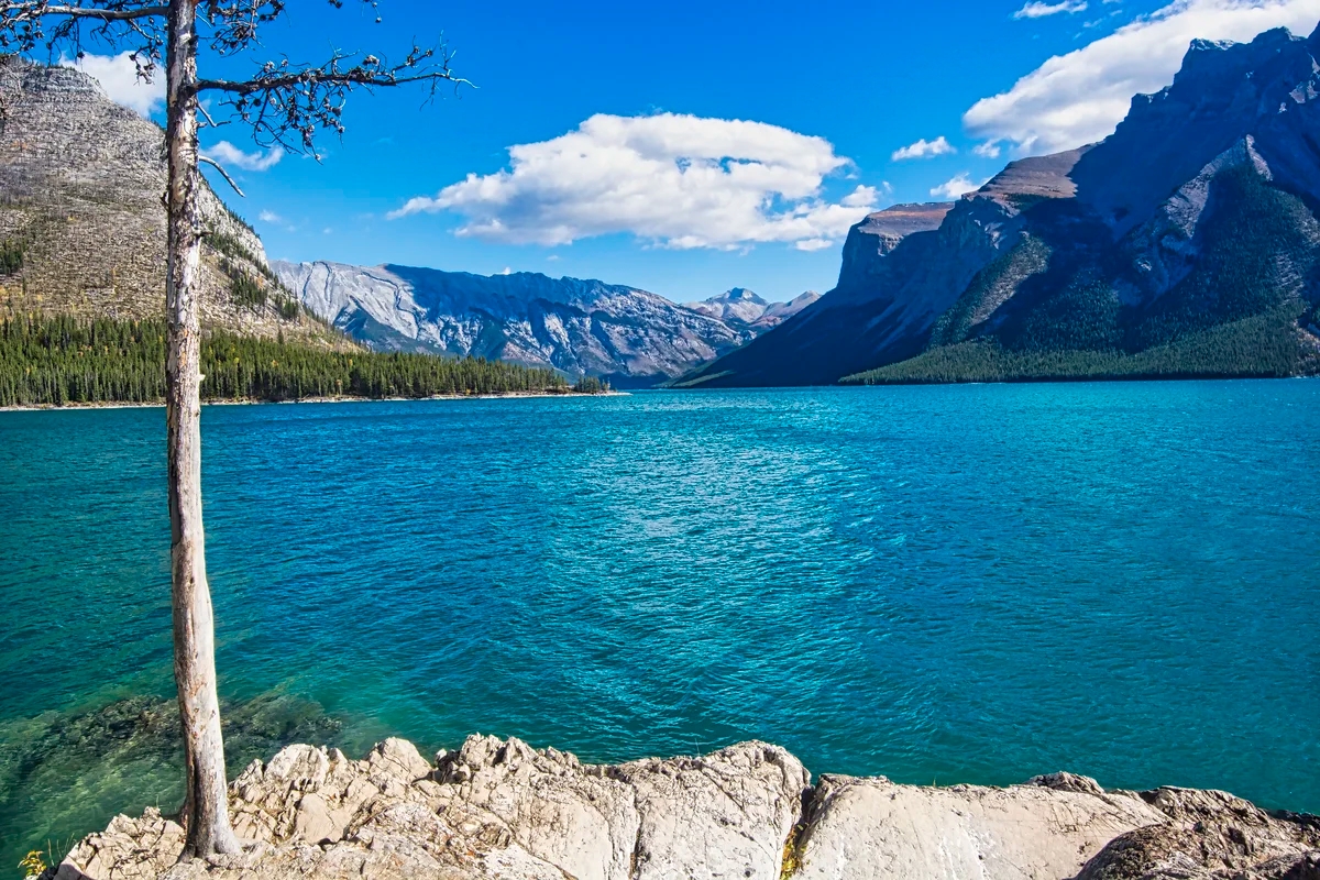
Lake Minnewanka from Picnic Area
Also go to the cruise dock and picnic area for views of the gorgeous turquoise lake.
Mt. Inglismaldie, Lake Minnewanka
Across Minnewanka (meaning water spirit), the largest lake in Banff NP, the most imposing feature is Mt. Inglismaldie (2964 m 9725 ft asl) with massive limestone cliffs on top of a grey shale layer.
Two Jack Lake picnic area
Continue along the scenic drive loop to a view of turquoise Two Jack Lake. This is the picnic area just after the campground entrance.
Vermillion Lakes
Vermillion Lakes are very attractive for sunsets framed by Mt Rundle. If you have a car or bike you can drive 3 miles on the Vermillion Lakes Road east just before the Trans-Canada junction to this view. There is also a great viewpoint on the Trans-Canada Highway eastbound only.
Mt Norquay Road 3.6 miles one way has the nice aerial view of Banff shown in the first photo above. The best viewpoint is the highest one.
What Wildflowers can I See in the Rockies?
The flowers of the Canadian Rockies can be found on many subalpine and alpine hikes such as Sunshine Meadows. You just need some sunlit areas. The issue is not where but when. Because of the high altitude, the best time for wildflowers depends on when the snow has melted. Sometimes this can be late June; sometimes late July. This means you usually need to go hiking in July-August.
Indian Paintbrush, Wildflower of the Rockies
Fireweed and Indian Paintbrush are exceptions as they are low altitude flowers, often seen along the roads. They are very common. Indian Paintbrush is one of the quintessential sub-alpine flowers from Alaska to the Andes.
Columbine, Subalpine Wildflower
Columbine is a beautiful and quintessential wildflower in Banff NP. It is found in subalpine forests (and in our garden) and is common in early summer.
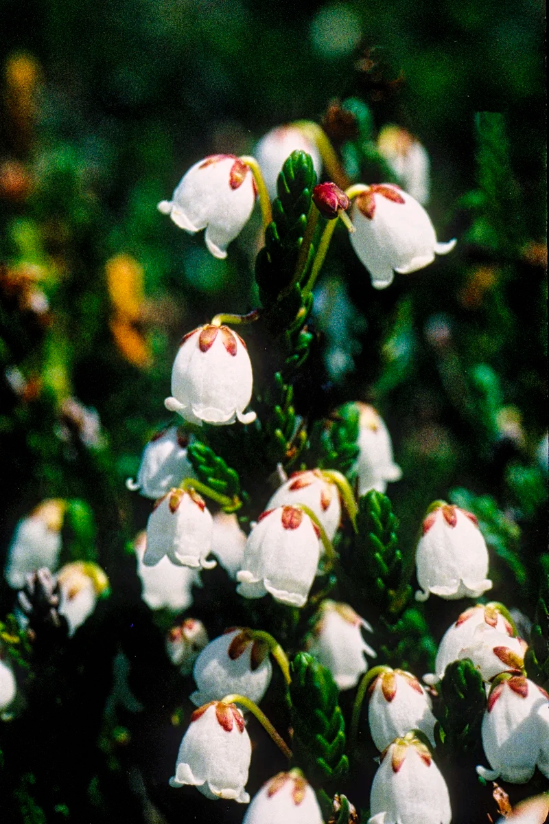
White Mountain Heather, Alpine Wildflower
White Mountain Heather is common in alpine flower that blooms early in summer.
Western Anemone, Alpine Wildflower
Western Anemone is a common alpine flower and blooms shortly after the snow melts. The blue Alpine Forget-me-not is another typical alpine flower.
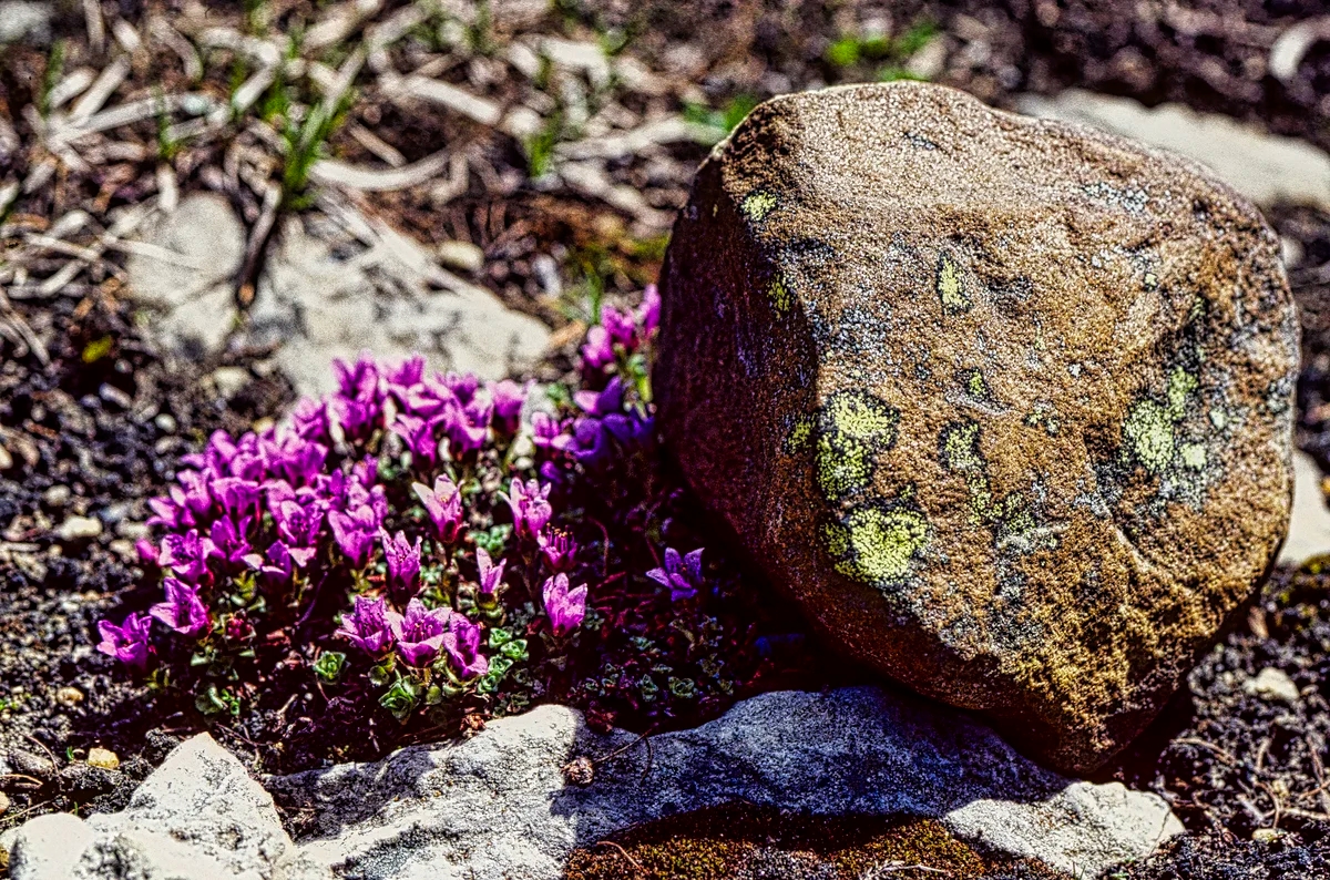
Moss Campion, Alpine Wildflower
Moss Campion is a pink alpine flower that grows very slowly. So slowly, it does not flower for its’ first ten years!
Banff Hiking Trails
The following are just two hiking areas you can do if you are based in Banff the town. There are many more hikes throughout the NP. Some of our all-time favourites are in the post Icefields Parkway – Do Not Miss the Best Road Trip in Canada.
Sunshine Meadows Trails
Howard Douglas Lake, Citadel Pass Trail
Sunshine Meadows is one of our favourite walks to take visitors, especially if you like alpine flowers and wide-open views. Best of all you can avoid the hike uphill by taking the bus or gondola (CAD 65) to Sunshine Village, a skiing mecca we really enjoyed in the winter.
Once you are in the meadows, you can hike to Howard Douglas Lake on the way to Citadel Pass. You can see all the way to the pyramidal Mt. Assiniboine (on RHS of the photo), over 15 km away. It is just you and wild nature — ok, there are lots of hikers as well. There are a few trails to do in this area.
Rock Isle Lake
Continue on to a picturesque view of Rock Isle Lake. We did not descend to the lake. Note that the peak flowering may not occur until late July depending on snowfall.
On one trip, we met a young hiker from NJ who asked to accompany us when we guided a Swiss friend around the Rockies. The NJ hiker told our Swiss friend, the Rockies are way better than the Alps because when you hike up the mountains all you see is more mountains. Needless to say, that did not go over well with our very patriotic Swiss guest.
Sunshine Meadows Hikes 5.8 km 2 hrs one way (OW) to Howard Douglas Lake; 9.3 km OW to Citadel Pass, gain 150 m (500 ft), elevation 2360 m (7800 ft); or backpack 27.2 km 2 to 3 days to Mt Assiniboine, gain 335 m (1100 ft).
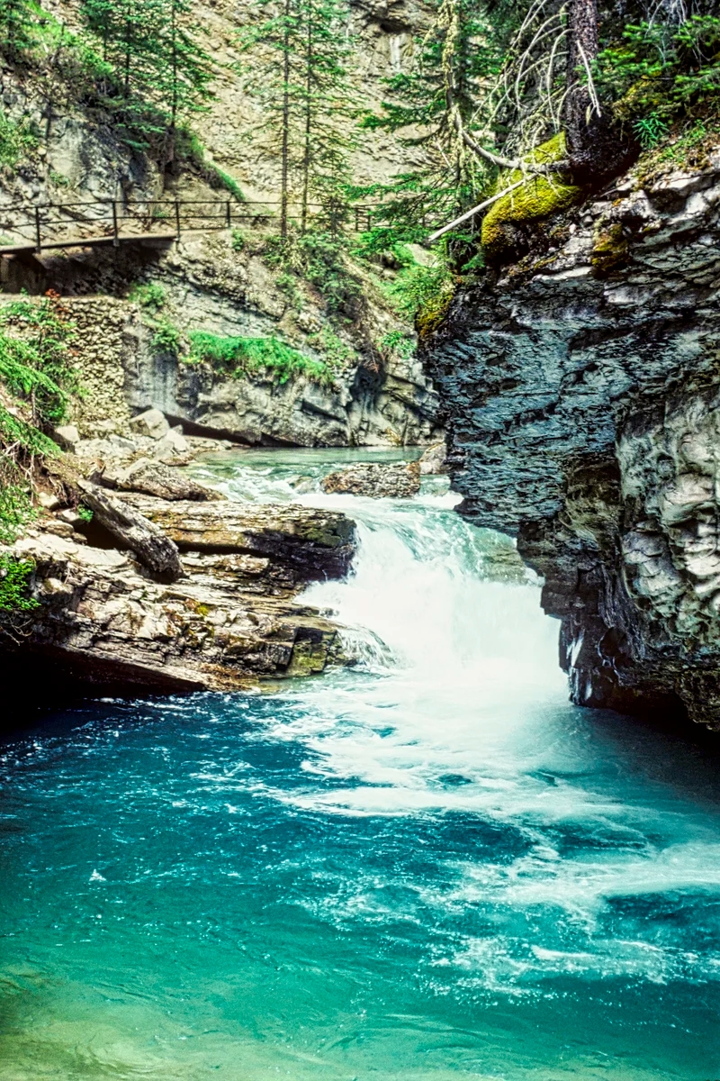
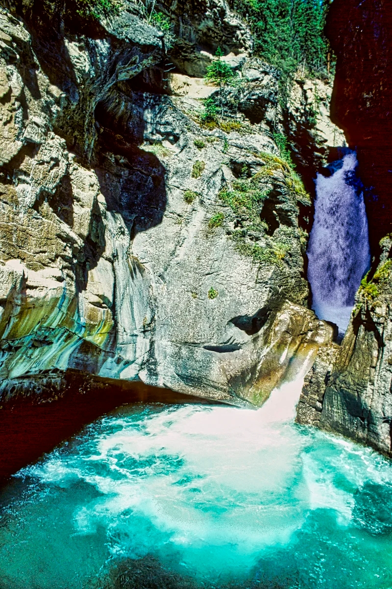
Johnston Canyon
Johnston Canyon Trail
This is a fun walk because you “hike” right inside Johnston Canyon on elevated boardwalks embedded into the sheer canyon walls. Many families go on this popular walk. It is easy and pretty with the gorgeous green water. It is also accessible nearly all year round.
There are waterfalls and lots of semi-circular potholes carved smooth by the water — actually it was the pebbles and rocks swirling in the water. The walls are made of soluble limestone, which is used today as ingredients for concrete, toothpaste, paint, tiles, medicines and cosmetics. But ask yourself why is there limestone here?
Johnston Canyon Waterfalls
Limestone is composed mainly of skeletal fragments of marine organisms such as coral and molluscs. This means this area was once a shallow tropical ocean and now we are in temperate, sometimes freezing Canada. OK, there was no Canada then just one super continent, Pangaea. Moreover, this rock is over 252 million years old! At that point in Terran history there was the greatest mass extinction — 95% of all life disappeared! And you thought you were just going on a pleasant walk.
The trail ends at the Ink Pots, six clear green springs of 1ºC water. You can hike three options though most tourists only go to the Falls:
1.1 km OW to Lower Falls;
2.7 km OW to Upper Falls; and
5.8 km 2 hrs OW to the Ink Pots; gain 215 m (700 ft).
What Wildlife can I See in the Rockies?
Mountain Range View from Trans-Canada Highway near Lake Louise
The Trans-Canada expressway (Highway 1) in Banff NP is lined with fences to keep the animals out – or is it to keep the humans in? There used to be “bear jams” in the old days when cars would simply stop and block the road to see animals along the road! Now, wildlife bridges lined with trees and other vegetation enable animals to cross over as if they are still in the forest!
There are mountains all along the road but the tunnel of tall lodge pole pines prevents you from seeing them. Then at the Lake Louise campground overflow area the intersection provides a break in the trees. This is the early morning view we got. It made getting up early worth the while.
To see wildlife, you need to get off Highway 1 and go hiking or on the smaller roads like the Minnewanka Scenic Loop, Highway 1A, and the Icefield Parkway (Highway 93) to Jasper. You probably need to go searching in early morning or late afternoon/evening. Note that days last until 22:00 hrs in springtime in Alberta.
Coyote, Johnston Canyon
We saw this coyote along Highway 1A near Johnston Canyon. At first I thought it was a dog walking on the road, then I noticed no tail wagging. I was able to get fairly close (the photo was cropped) and the coyote just stood there posing for me. In all our ten years living in Alberta, this was the only time we saw a coyote in Banff NP.
Hoary Marmot, Subalpine Wildlife
The animals most people want to see are Bighorn Sheep, Mountain Goats, Bears, Moose, Deer, and Wapiti. There are two other animals that we most identify with the Rocky Mountains. The can only be seen by hiking. The marmot lives in ground boroughs or rock slides near timberline. They are often seen getting a suntan. The big-eared, tiny pika lives in sub-alpine or alpine rock slides like the Rockpile at Lake Moraine or Mount Edith Cavell in Jasper NP.
What Birds can I See in the Rockies?
Birders can enjoy 329 species in the Banff region. Use the Cornell Univ. eBird web site to find out what has been seen and where. There are two birds you will have no problem seeing as they come close to you.
Black-billed Magpie
The Black-billed Magpie (corvid family) is found in western North America. While it is primarily black and white, it becomes spectacular when it reveals iridescent blue or blue-green.
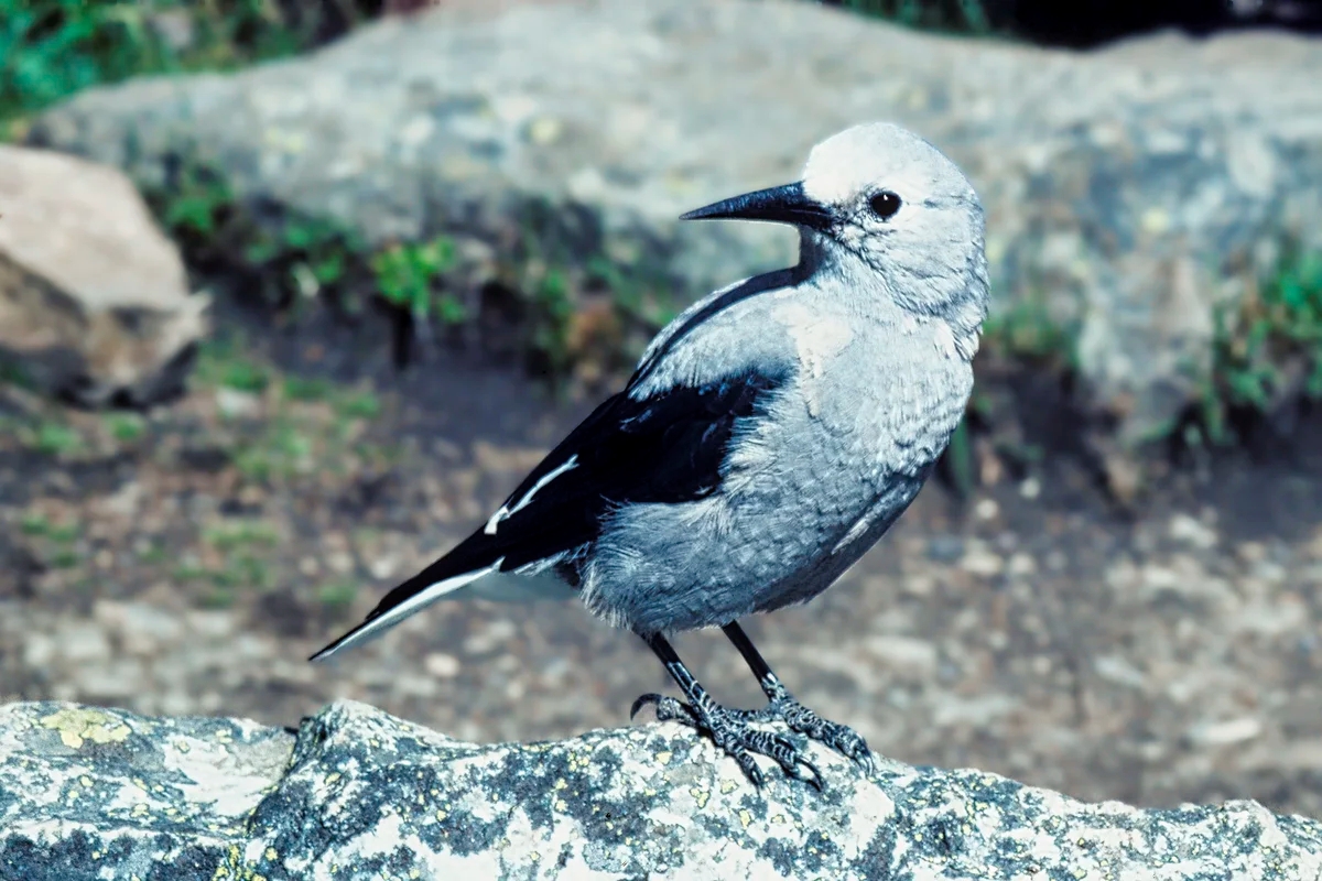
Clarke’s Nutcracker
Clarke’s Nutcracker (corvid family) is related to the jays. It is found in coniferous forests at high elevations since it feeds on pine cone seeds.
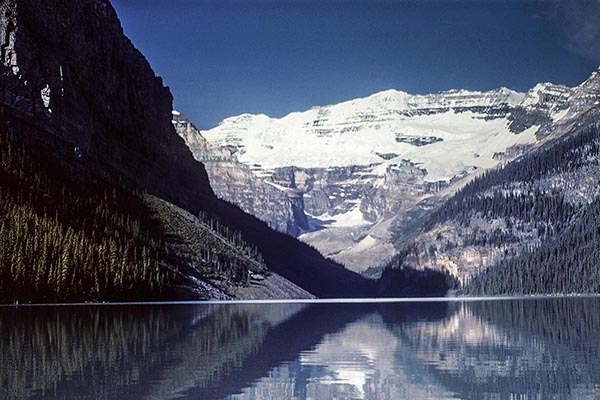
Lake Louise
Lake Louise is the most over-populated site in the Rockies. For us it has been spoiled and you even have to pay $21 to park there! Yes, it still worth seeing but check out the shuttle bus alternatives below. Imagine, the first road to Lake Louise was only built in 1920. Nowadays, in order to find parking in the limited space, come early in the morning. Alternatively, you could come late in the day but the mountains face east and may be in the shade.
However, in the spring the days are very long and sunset is at 22:00 hrs. When my in-laws came from Montreal on their first visit (we were working in Alberta), my wife had us doing a morning hike, an afternoon hike and, why not, an evening hike. It is still light after 22:00 hrs! Try to tell your children why they should go to sleep even though it is still light outside!
Lake Louise from the Chateau
What to Do in Lake Louise
Lake Louise and Mt Victoria
Chateau Lake Louise sits atop the terminal moraine of Victoria Glacier, which today has receded back to the precipice of Mt Victoria in the photo above.
Bride and Groom, Chateau Lake Louise
Chateau Lake Louise is a popular venue for weddings. We enjoyed the harp player and the well-dressed guests. We participated in their photo shoot.
The Wedding Dog
But best of all, we loved the wedding dog dressed in a tux! The cuddly-looking Chow Chow was very well behaved. It is one of the oldest dog breeds in the world, dating way back to ancient East Asia.
Lake Louise Hiking Trails
You know this area has the busiest hiking trails when they provide tea houses at the end. We have not gone here since Banff NP became over touristy.
Near the tiny bridge at Chateau Lake Louise for the view above. The lake outlet enables you to minimize the number of tourists in the photo.
Lakeside Walk is flat and accessible if you cannot hike and is very pleasant since the further away you walk the less tourists. It actually is the first part of the Plain of Six Glaciers Trail
Lake Agnes (and the Beehives) Trail (map) 3.4 km 2 hrs OW; gain 367 m (1205 ft), elevation 2099 m (6885 ft); the Beehives are another 1-1.6 km further and uphill, offering great views of the Bow Valley
Plain of Six Glaciers Trail (map) 6.6 km 2 hrs OW; gain 670 m (2200 ft), elevation 2410 m (7900 ft) , offering great views of Mt Victoria and Victoria Glacier
Lake Louise Ski Hill for this spectacular aerial view below.
Lake Louise from the Ski Hill
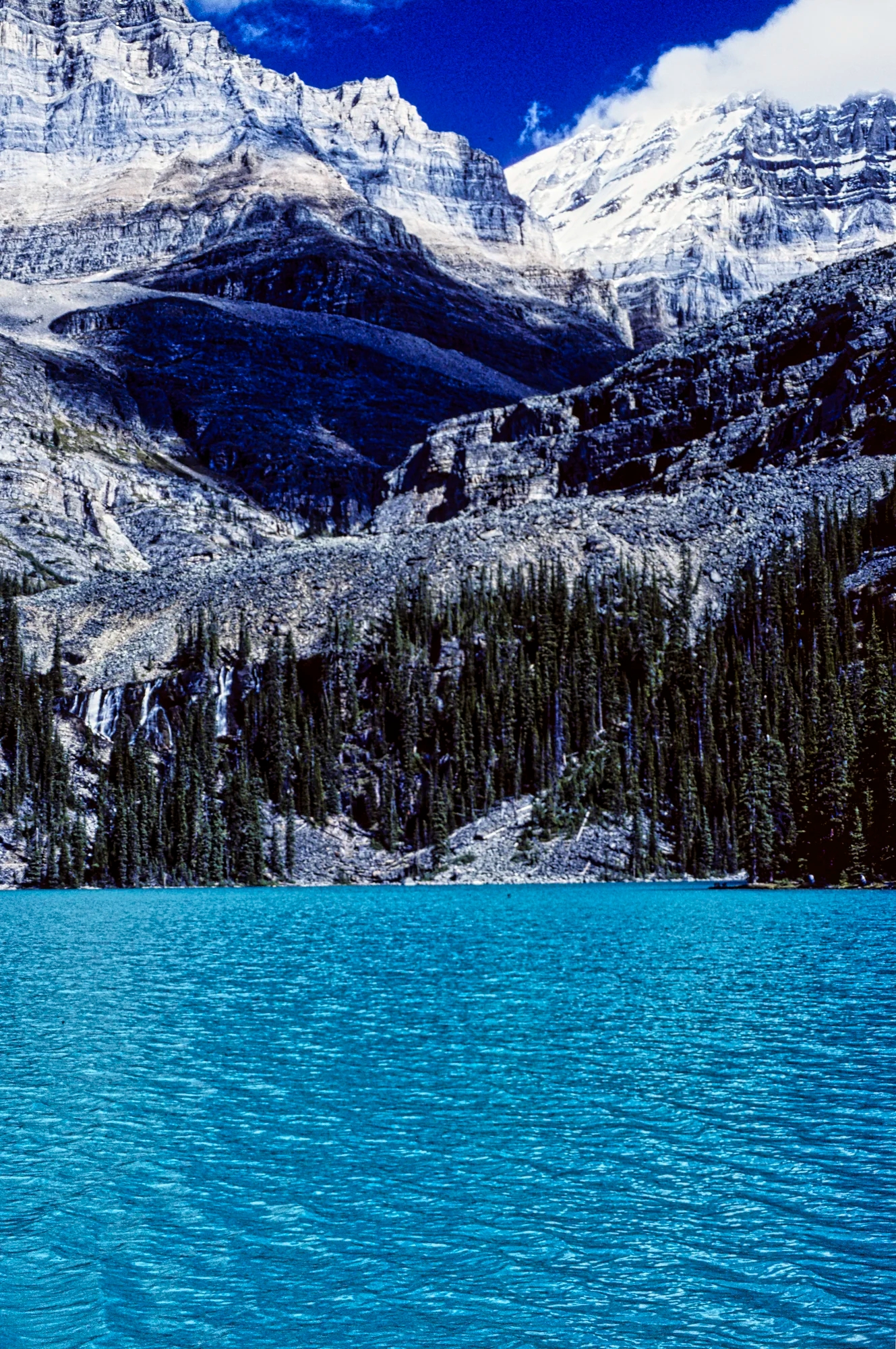
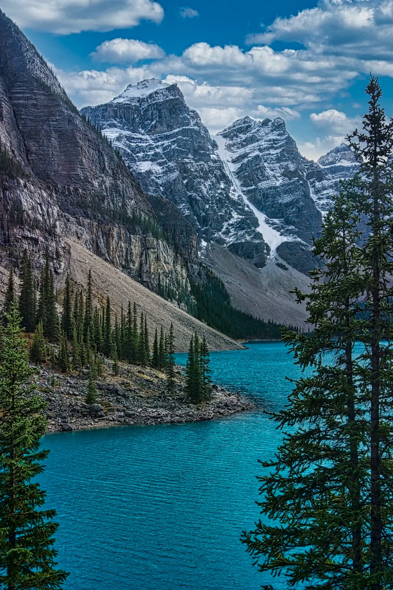
Moraine Lake
Moraine Lake at Late Afternoon
The Moraine Lake road forks off at the Lake Louise parking lot and ascends 14 km. You will pass beautiful vistas but can no longer drive to Moraine Lake. You must take the $8 shuttle. If you plan on doing the hikes you need to check out how the return trip works.
At an altitude of 1884 m (6181 ft) asl, you arrive at one of our top three lakes of the Rockies. Moraine Lake has a majesty about it with gorgeous green-blue water surrounded by ten towering, snowy Wenkchemna (Stoney Indian for “ten”) Peaks. Yes, it’s definitely one of the best views and our top three (Moraine, Emerald and Peyto) does not include Lake Louise! Chacun à son goût!
Moraine Lake Hiking Trails
Due to frigid winter of high altitude mountains, the lake is frozen and the road closed. Therefore, the best time to visit is May to September, possibly October.
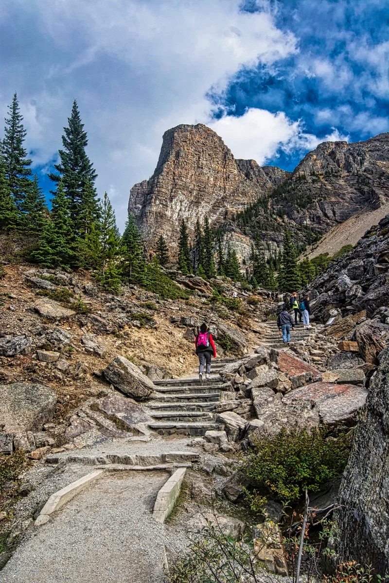
Rock Pile Trail
Rockpile Trail with Tower Of Babel in Background
The limited view of Moraine Lake next to the parking lot just does not cut it. Instead, you must walk on the east side of the parking lot and go on the uphill but very short Rock Pile Hike to see these special views. If you come at the end of the day the peaks and lake will be in the shade since the they face east. This is especially true in late summer.
When we first “discovered” this “trail” decades ago there were no markings, barriers or stone stairs. It was just a scramble up the rock pile. There were very few people!
Exhibit, Rock Pile Trail
Now this short walk comes with lots of interpretive signs and lots of tourists. Would you have stopped at this exhibit? The rock you are about to walk over is a fossilized beach, proof that this area was once at sea level.
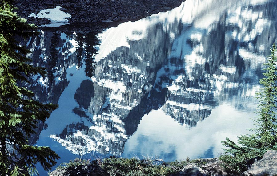
Wenkchemna Peaks Reflected in Moraine Lake
Glaciers are nature’s bulldozers and moraine is the gravel they push ahead. To understand the power of glaciers, just think about the gigantic area of the flat Prairies (aka the Mid-West in the USA). This was the result of a massive and up to two-mile thick icefield that bulldozed most of North America and gouged out the Great Lakes.
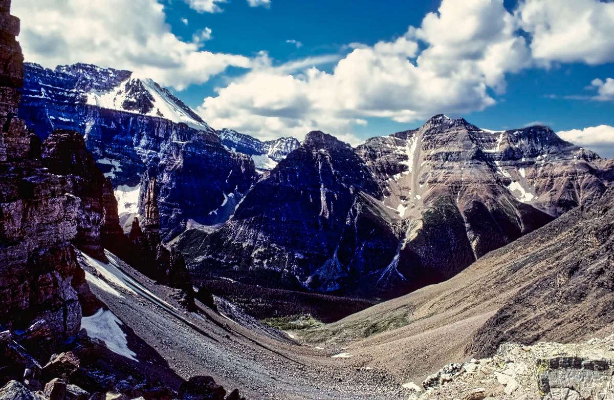
Wenkchemna Peaks and Moraine Lake from the Rock Pile
The early explorer Wilcox thought the rock pile was a terminal moraine. Hence the name Moraine Lake — but that is a misnomer as it is not a moraine. It is actually a rockslide from the Tower of Babel directly overhead that dammed the lake.
Be on the look out for the tiny pika (rabbit family) with cute round ears that hang out on the rocks — or at least used to. Now it is a great place for photographing wedding bunnies!
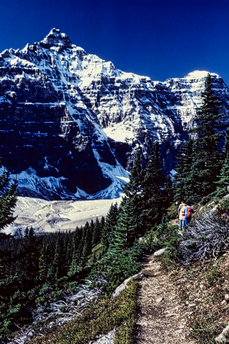
Larch Valley Trails
Some of the best hikes in the Rockies depart from the right side of the very small Moraine Lake parking lot. The first 40 minutes of endless switchbacks through forests is the same for all the trails.
After a steep climb of 457 m (1500 ft) in 2.4 km, you reach the trail junction. Eiffel Lake is to the left and Larch Valley-Sentinel Pass is to the right.
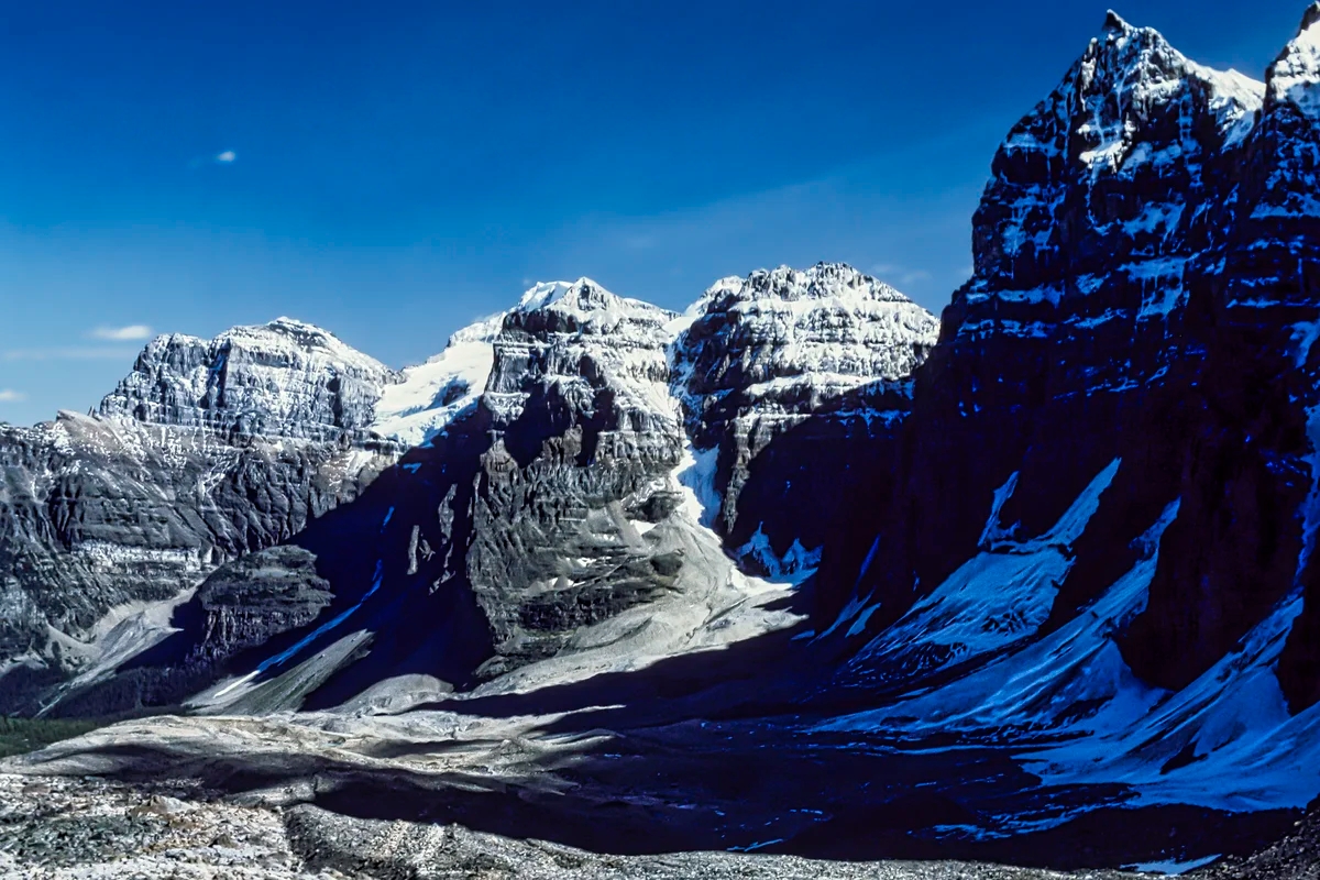
Eiffel Lake Wenkchemna Pass Trail
Wenkchemna Peaks, Eiffel Lake Trail
The Eiffel Lake Trail offers unparalleled views of the Wenkchemna Peaks. This may be your destination or you can continue on to the Wenkchemna Pass (5.8 km).
Wenkchemna Peaks from Alpine Meadows
One of the best things about the Eiffel Lake hike is that you will enjoy virtually non-stop views of the Valley of the Ten Peaks the entire way with less people.
Eiffel Lake Trail: 5.6 km 2-3 hrs OW; gain 365 m (1200 ft), elevation 2255 m (7400 ft);
Wenkchemna Pass Trail: 9.7 km; gain 724 m (900 ft), elevation 2600 m (8530 ft);
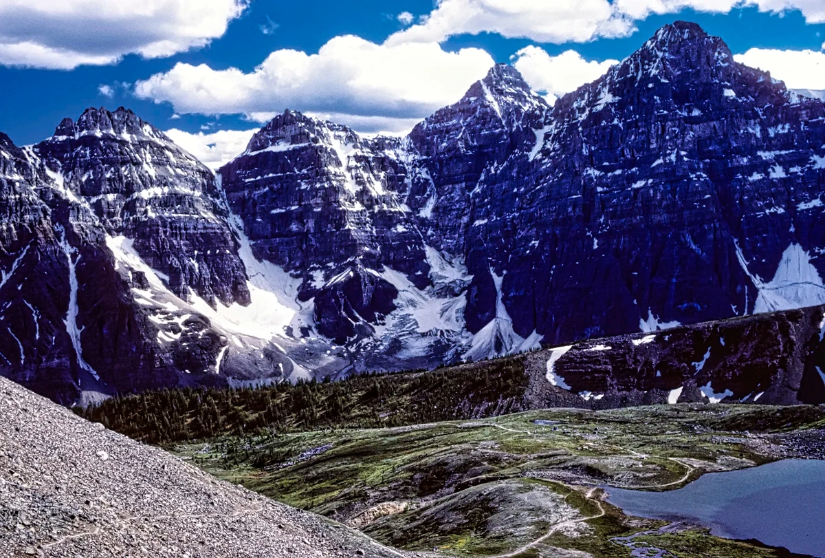
Larch Valley – Sentinel Pass Trail
Wenkchemna Peaks from Alpine Meadows
From the trail junction, most hikers take the trail on the right to Larch Valley and Sentinel Pass. The trail is especially beautiful on a sunny day in the fall when the larch trees turn golden. But Larch is a coniferous (“evergreen”) tree, the only one that drops its needles.
Wenkchemna Peaks from Alpine Meadows
Larch Valley Trail: 2.4 km 0:45 hrs OW 2.5 hrs RT; gain 275 m (900 ft), elevation 2270 m (7450 ft);
Sentinel Pass Trail: 5.8 km 3 hrs OW; gain 720 m (260 ft), elevation 2611 m (8566 ft);
Sentinel Pass Views
Wenkchemna Peaks from Sentinel Pass
At the end you may feel like quitting and you still have to hike up steep switchbacks (hope you are in shape) to one of the most dramatic views. It is also the highest hiking pass in the Canadian Rockies at 2611 m (8566 ft) asl. The pass is a saddle with extremely steep slopes and clear views on both sides. These photos show are the views of the Larch Valley side followed by the Paradise Valley side.
Mount Temple from Sentinel Pass
The view further to the left is of the fairly high Mount Temple 3544 m (11,627 ft) asl. It was named after Sir Richard Temple, Governor of Bombay from 1877 to 1880. It comprises 550 million year old quartzite and limestone, which means this rock was originally below the ocean.
Paradise Valley from Sentinel Pass
It’s a long descent over talus slopes to Paradise Valley. You can exit via this route to the Moraine Lake Road but you need transportation to get back to your car.
What to Read about the Rockies
The two books should be available in any bookstore in Alberta and are on Amazon.
Parkways of the Canadian Rockies(Brian Patton 2008, CAD 24.47) is like bringing a naturalist along to interpret what you should be seeing.
Canadian Rockies Trail Guide(Brian Patton & Bart Robinson 2022, CAD 29.95) is the best hiking book we have seen or used in all our travels around the world.
Travel Tips page provides advice that applies to any trip (you can access via the Terra Encounters menu as well).
Where to Stay and Eat in Banff NP
Banff has excellent supermarkets, cafés, and restaurants. Some are listed on the Rocky Mountain Itinerary Map. We are not going to recommend any. Search for a place on Google maps and it gives a Google rating based on the opinions of all people not just tourists. Any rating over 4.4 out of 5 is excellent.
Banff has excellent campgrounds: a)Two Jack Lake (tent site $23 to $29); b) Tunnel Mountain Campground (tent site $29) is open all year-long and we have camped there on ski holidays.
The problem in the summer is that they are reservable and it can be hard to get in at the last minute. Avoid weekends and statutory holidays. There is an overflow area, but it is better suited to vans and trailers. WE used to come here Thursday night then get a campsite the next morning.
Hotels are very hard to come by and very expensive during high season — which is most of the year due to the excellent skiing. When we last checked, all rooms in the summer cost more than CAD 428 except for hostels, which were CAD 125 for a dorm bed. Plus you have to book well in advance. Summer now extends into September! The rates go “down” to CAD 260 in late September. We were shocked on two return trips in late September how busy it still was!
Banff is a good base for the places described in this post, but it is not centrally located for the rest of the itinerary; i.e. it requires more commuting time. On the other hand Banff has better facilities, restaurants, and a supermarket. We would buy all our non-perishable food from Edmonton and fill up on gas before hitting the more expensive Rockies. We did have a van and a plug-in cooler.
To save you time we have designed a Rocky Mountain Itinerary Map with estimated distances and driving times. There are so many places to see that we have divided this road trip into three separate itineraries (layers in the Google map). Some layers such as Accommodation and Food are initially hidden to keep the focus on the sights. We have include additional points of interest not described in these posts.
This may give the false impression that you only need three days to see the Rockies. This is possible if all you want to do is drive. We would encourage you to stop at all viewpoints and go hiking, especially if you have time and the Parkways of the Canadian Rockiesbook above.
If you plan to go hiking, taking tours, visiting interpretive centres and programs, then you will need far more days. Banff NP (6,641 sq km) is about the size of the state of Delaware and larger than the province of Prince Edward Island. Then there are three other contiguous parks. Three days is not enough to see the quintessential Rockies.
Parks Canada Passes
Since the Trans-Canada goes through Banff NP, you can transit through the park without any fees. But the minute you park, hike, drive the Icefield Parkway, or do some other activity — you must have a NP pass. The day pass is $10.50. The annual Discovery Pass is $72.25 for all 80 Parks Canada sites. There are no multi-day passes. There are discounts for children and seniors.
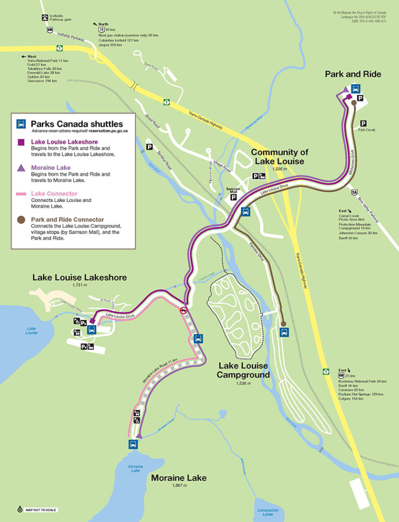
Parks Canada Shuttles
Parks Canada Shuttle Map
The Parks Canada Shuttle runs every 20 mins. from Lake Louise to Moraine Lake is $8. Parking at the Lake Louise/Chateau parking lot has zoomed up to $21. There are shuttle buses from Lake Louise village to Chateau Lake Louise you can check out. There are also buses from Canmore and Banff (town) to Lake Louise.
Our recommendations are not influenced by affiliate links – we have none. Our content and advice is derived from our personal experience and knowledge based on living in Alberta for ten years. We are avid hikers, nature lovers and photographers. The Rocky Mountains were our weekend playground as well as vacation destination.


You must be logged in to post a comment.