Our recommendations are not influenced by affiliate links – we have none. Our content and advice is derived from our personal expertise, experience, and knowledge based on living in Rome for four years and studying its art, architecture, and culture.
Judging from all the questions, there are several misconceptions surrounding the Fall of Rome.
Plagues Decimated Rome
At its peak in 133 to 200 CE, it is estimated that Rome had 1,000,000 people. This decreased dramatically due to various plagues brought in via the Silk Routes.
Plague of Cyprian
Imagine a continual pandemic from 249 to 262 CE! Just like the Black Plague, the Plague of Cyprian probably wiped out 1/3 to 1/2 of the Roman population. This is just a guestimate as there were no stats in those days!
Corruption and Decline
Add in 50 years of civil war, called The Anarchy. This span saw 25 claimants to the throne, most of whom were assassinated. The Palmyrene Empire had split off the Middle East provinces for a short time (260-273 CE). The Roman Empire also lost France and Britain to the Gallic Empire in 271 CE. So pieces were hived off well before 476 CE.
Economics
Rome itself did not produce any material wealth. They lived off the pillage of war and a slave economy. Most Roman citizens did not work. But Rome was no longer strong enough to conquer new territories. Civil unrest during The Anarchy crisis made it hazardous for merchants to travel and the internal trade network collapsed.
Mercenary Army
The Romans always included local militia in their defence of the Empire. At the time of Emperor Augustus, 65% of the army came from Roman citizens. By the mid-second century this had dwindled to 1%. The Romans had become soft. Due to the population decline and increased series of invasions, Rome started relying on Germanic tribes for their army.
Rome the City Fell in 476 CE
Rome suffered three major sacks before its’ demise:
Rome the city fell in 476 CE because it could no longer pay its mercenaries. Odoacer, head of the Germanic mercenaries protecting Rome, took over the administration of Rome, nominally on behalf of the Roman Empire. The city continued to function.
Loss of Architectural Heritage
The word vandalism meaning wanton destruction originates from the Germanic tribe, the Vandals. However, most of the Germanic attacks did not destroy the buildings and monuments of Rome. Many of these so-called Barbarians were already Christian.
Vestal Virgins, Roman Forum, Roma
However, the later Medieval and Renaissance Christians believed these Roman temples and artifacts were pagan. Notice how all the heads of the statues of the Vestal Virgins were destroyed except one. This was no accident. Vestal Claudia had converted to Christianity in 364 AD and hers is the only statue still intact!
The Forum and other sites were not just destroyed. They used the stone to build new Medieval and Renaissance buildings! Significant damage was also caused by major earthquakes.
Pantheon Dome, Rome
The sites that survived had been converted into Christian places of worship. The world-famous dome, the Pantheon (temple to all the gods) became the church of St. Mary and All Saints. For some really interesting facts about the significance of the Pantheon, see Discover the Secrets of Ancient Rome – Part 1.
Our word basilica comes from the huge halls of the same design as our present day churches that were used for law and commerce. In other words, our Christian basilica is based on Ancient Roman architecture.
Rome the city fell in 476 CE but the eastern and southern half of the Roman Empire along with Pax Romana continued to exist for another thousand years. Ancient Roman architecture, such as the very famous Aya Sofia (Constantinople) above, continued to be built.
In other words, prosperous Constantinople (now Istanbul), which was the financial and educational centre of the Roman Empire, became the political centre. Important things to know are that:
people of that time still called it the Roman Empire;
the principle language of this empire was Greek not Latin;
the term Byzantine Empire was only coined in the 16th century by a German historian – it never existed!
Silk Routes
But all roads really did lead to Nova Roma, i.e. Constantinople. It was the financial capital of the Roman Empire because it became the terminus of the Silk Routes — note the plural because there were several routes both by land and by sea. Constantinople became the largest and wealthiest city of Europe up until its zenith in the 12th century with a population of around 600,000 people (in 600 CE).
The Byzantine/Roman Empire was still huge as shown in this map of 555 AD. It just did not include the northern parts of Western Europe.
What happened to Rome the city after it fell? The city faded in importance. The Roman Empire (Constantinople) regained control of major parts of Italy but the capital of the much smaller Western Rome was now Ravenna.
Saracenic-Gothic Architecture of the Grand Canal, Venice
In 810 CE, Venezia became an independent republic and in 1082 CE made a free trade deal with Constantinople. Thanks to their more powerful navy, Venice monopolized trade between Constantinople and Western Europe; in other words, all trade with the Silk Routes. Because of their navy, they made a fortune transporting Western armies to the Holy Land during the Crusades.
There is a reason for all the incredible buildings and monuments in Venice during the so-called Dark Ages. They were not dark in Venezia, which became one of the largest cities in Europe, ten times the size of Rome! It became one of the powerful city-states of the Medieval Era and controlled much more territory the the present-day city of Venezia.
Medieval Italy was the birthplace of the modern city-state that led to the demise of feudalism, the rise of the Renaissance, and the rise of mercantilism and thus capitalism.
Venice became even more powerful than Constantinople, which it sacked in 1204 seizing most of its Greek islands in the Aegean and along the Turkish Coast. Venice was THE major West European power until it was conquered by Napoleon in 1797!
The Country of Italy did not Exist
The rest of present-day Italy was divided into many provinces ruled by France, Spain, the Habsburgs and the Vatican! The Vatican was the feudal lord of the Papal States. The country of Italy did not exist until 1871!
European Expansionism
Europe changed history by looking for colonies and resources outside of Europe. The fall of Rome (the city) did not lead to this. It was the gradual decline of the Roman Empire and then the Fall of Constantinople in 1453. The Fall of Rome was important because it led other European countries to aspire to be world empires.
Europe was forced to explore because the Ottoman Empire (Turks) monopolized and throttled the Silk Trade Routes, which had also become less reliable. The Europeans wanted to bypass these obstacles.
Contrary to what we think, scientists at that time already knew the world was round. They just had no idea that North and South America were in the way travelling west to Asia nor how large was the circumference of the world. The explorers would not have had enough food to make it to the Far East if there had been only ocean.
So the Portuguese and Spanish began the quest to circumnavigate the world to reach the Orient and its important spice and other trade goods. Then the Portuguese discovered the route around South Africa.
The main difference between this expansionism and previous Terran empires was that the Europeans had technologies that enabled them to project their power using superior weapons and naval fleets to maintain their control of remote colonies.
Other Posts You May Like
The following posts provide more information on the Roman Empire:
Our recommendations are not influenced by affiliate links – we have none. Our content and advice is derived from our personal expertise, experience, and knowledge based on living in Rome for four years and studying its art, architecture and culture.
Is Travel About Looks or Learning?
Coliseum from Colle Oppio Park, Rome
The following question was asked on Quora:
Which is worse, looking like a tourist or going to Rome, Paris, and Egypt, but missing the Coliseum, the Eiffel Tower and the Pyramids?
Looking Like a Tourist
Why should you worry about looking like a tourist? You probably would look like a tourist even if you were trying not to. Do you carry a camera? a guidebook or map? a backpack? Shorts, Hawaiian shirts, and flip flops scream tourist.
If you are worried about pick pockets, keep alert of your surroundings at all times. Do NOT put valuables in the outside pockets of your backpacks or your clothes. One pick pocket tried to take the wallet in the back pocket of the jeans of my father-in-law, Dave, when he visited us in Rome. Normally, that would be a very bad place for a wallet. But Dave had secured the pocket with a safety pin – Dave 1 Thief 0. We still don’t recommend this and you should use a money belt for your valuables.
Most people don’t care what you are wearing unless it is offensive to their culture or religion. In fact, it may be easier to engage with the locals if you look like a lost tourist asking for help.
Purpose of Travel
Pyramids, Giza, Egypt
We have lived and travelled in many countries for 23 years, including a three-year Round-The-World trip and living in Rome and London for seven years. While we worked in Europe, we still visited the major tourist sites with camera in hand – a dead give-away.
Connecting with the Locals
Probably the most impactful aspect of any trip is to meet the local people. This is the best way to learn about the culture. The key is to have an open, friendly face. Even more important is to have a genuine interest in the people you meet. Be open to different beliefs and cultural values.
Seeking What is Unique
While we all want to have a good time, why would you not seek out the places that are quintessential to that country? We strive to do things that are unique to each country. The point of travelling is to learn about the culture, cuisine, people and history of your destination. We gave courses at universities about our experiences.
Museumed Out
Boxer at Rest, Capitoline Museums, Rome
The main problem is that tourists get “museumed out” or “templed out“. They end up more exhausted than this Ancient Greek boxer after his match. The only way to get more out of your trip is to learn why the artefact or place is so significant. How did each major site, leader, or artist have an influence on the next major site, leader, or artist? This is what we learned from travelling Round The World for three years without ever getting “templed out“.
The following are some examples of why these sights should not to be missed.
Domed Out
Pantheon Dome, Rome
Why is the Pantheonthe most important temple to visit, possibly in the whole world? It should not be because of name recognition. It is much more than being one of only three intact temples in Rome. How has it influenced modern architecture? Without the Roman invention of concrete we would not have the massive buildings of today.
The first dome built since Ancient Rome was the Duomo (the dome) in Renaissance Florence. The Duomo was modelled after the Aya Sofya Church in Constantinople (Roman Empire), which was modelled after the Pantheon in Rome.
The Pantheon was the largest dome ever built until the Astrodome in Houston!!! Without the Pantheon in Rome we would not have domes today!
Planned Out
Miletus Theatre, Turkey
Our city centres are laid out today the same way they were designed by ancient urban planner, Hippodamus, in 494 BC. We have a rectangular grid of streets and a downtown/civic area (e.g. agora and temples) just like in Miletus & its Roman Theatre, ancient Turkey.
Why do Istanbul, Ephesus and Venice have so many magnificent monuments and buildings? Because they were a terminus of the Silk Trade Routes.
Every major tourist sight today was the result of that place being a major capital, commercial or religious centre in the past.
Sports Fanatics
Vomitorium, Theatre of Miletus, Turkey
When you visit the Coliseum imagine that the architects have to allow 60,000 unruly fans to quickly exit. The word fan originates from the Latin word for fanatic.
The English word “vomit” originates from the Latin vomitorium, “to spew forth”? No, a vomitorium is not the room where you throw up! Now visit the Coliseum and realize how all our arenas are based on that design. There are vomitorium passages situated inside the arena under each tier of seats.
These are just a few examples of how the things you see when you travel have real meaning for the life you are leading today. So go forth and learn!
Other Posts You May Like
The following posts provide more information on the Roman Empire:
Our recommendations are not influenced by affiliate links – we have none. Our content and advice is derived from our personal expertise, experience, and knowledge based on living in Western Canada as well as travelling and living for 23 years around the world.
Why You Should do the Vibrant Victoria Walk
I fell in love with Victoria. She wears flowers everywhere. She loves all kinds of ethnic food. She has several scenic hills. She adorns the sea with gorgeous views of the Olympic Mountains. Named after famed Queen Victoria, Victoria British Columbia (BC) may just be the best small city to visit in all of North America.
We have been here a few times when we used to live on the West side of the continent but this was the first time we spent a whole week. Weirdly, it was like we were the ones at home as we picked up our son at the ferry from Vancouver to visit with us for the weekend.
The Homecoming sculpture (Wharf Street) above captures that magical moment when a sailor returns home and greets his daughter. OK, our reunion with our son was not quite as dramatic as we just spent the previous week together — but we do not see each other often as we live 4500 km (2800 mi) to the east! It is closer to fly from here to Honolulu!
Capital of British Colombia
Victoria Harbour
Bus Stop, Victoria Harbour
Naturally, the best place to start exploring is to walk from the tourist bureau on Wharf Street along the harbour with lots of flowers, boats and cute yellow water taxis.
Parliament Building
In the background is the provincial Parliament Building dating from 1897. Note the Romanesque (semicircular) windows with mini-columns. Vancouver is a much larger city. So why is little Victoria, with only 357,690 people, the capital of British Columbia?
BC Parliament Building
Governor James Douglas
After its start as a Hudson’s Bay fur trading post by Sir James Douglas (1843), Vancouver Island was the only British colony in the West because the rest of today’s Canada was “ruled” by the Hudson’s Bay Company (HBC). However, thanks to the Fraser Gold Rush (1858), the area of mainland British Columbia (BC) was inundated with Americans. And they wanted BC to join the USA.
Governor Douglas of Victoria saw the threat to a future Canada if BC became part of the United States. In 1858, he unilaterally declared British sovereignty and laws over the BC mainland. There were no telephones in those days to get the Queen’s approval. Fortunately, Queen Victoria, immediately endorsed the actions of Governor Douglas and so BC became part of Canada rather than the United States.
Victoria Centennial Fountain, BC Parliament Building
Most tourist just take in the very static view of the parliament buildings from the harbour side. For another hidden gem, walk around to Superior St. at the back of the complex and see this beautiful view in the early morning light. Here is the Victoria Centennial Fountain (1962). Sea otters frolic on the central rock. Don’t miss the bears patrolling the fountain wall. There also are bronze sculptures of an eagle, gull, raven, and wolf. The animals represent the province’s geography and history. See the Outdoor Self-Guided Walking Tour for a map and brief descriptions of the sights around parliament.
British Columbia
BC is a massive province (944,735 km²) that is 20% bigger than Turkey or 36% bigger than Texas but with only 4.6 million people. Victoria is on “small” Vancouver Island (31,285 km²) about the size of South Carolina, Belgium or Taiwan.
In 1869, HBC was pressured by the British government to reject an American government offer of CA $10,000,000 to buy Rupert’s Land. Considering its much larger size, that would have been quite a steal given the $7 million the USA spent to buy a much smaller Alaska. Instead, the HBC sold it to Canada for $1.5 million. That was quite a deal, except HBC never paid for it in the first place!!
Empress Hotel
Empress Hotel Gardens
The iconic landmark of Victoria is the Empress Hotel (1908) with its old world Edwardian feel. Believe it or not, the run down hotel was nearly pulled down in 1965. Thanks to a $45 million dollar renovation, it has thrived. In addition to serving beautiful décor and traditional Devonshire tea, don’t miss the grounds of the hotel strewn with gorgeous flowers. In fact, Victoria is the City of Flowers. That is probably its’ most special feature. Flowers adorn every street downtown.
Hidden Gems
The other special thing about Victoria is finding neat places a short distance from the touristy harbour/downtown area.
Thunderbird Park
Thunderbird Park Totems
Just around the corner from the Empress Hotel is Thunderbird Park on Douglas St. It is full of real totem poles and even a meeting house. The presence of Indian culture is palpable in BC. In fact, 17% of Canada’s aboriginal people live in BC.
First Nations
Thunderbird Park
Canada’s Indigenous people prefer the term First Nations for both the people as well as their lands. They own large parts of the province and now many of these areas have become self-governing First Nations (FN). Many of the FN territories in the north built community centres where visitors can meet FN people and learn about their culture.
Do not miss the Nisga’a Museum (New Aiyansh) north of Terrace BC. See photos and more details in our post British Columbia: 5 Hidden Gems You Must See. It has some of the best artifacts anywhere and the free guide was a superb, enthusiastic teenage girl who was a font of information.
St. Ann’s Academy
Tree-lined Entrance to St. Ann’s Academy
A short walk from here is a very beautiful “park” at 835 Humboldt Street. A tree-lined road leads to St. Ann’s Academy (1871), a convent and the first BC school for girls.
Flower-filled Gardens of St. Ann’s Academy
The Quebec Provincial style property was sold to the province of British Columbia. This National Historic Site is now the BC Ministry of Advanced Education.
Chinatown
Chinese Public School
North of St. Ann’s is the first and oldest Chinatown in Canada. The Chinese immigrated to BC during the various gold rushes and some never went back thus starting the Chinese-Canadian community. Due to prejudice, the Victoria School Board issued a policy in 1908 allowing only Canadian-born Chinese children to attend Victoria public schools. In response, the first school for Chinese students was built in 1909. The school at 636 Fisgard St. is still being used.
It was funded by the Chinese Consolidated Benevolent Association. It should be noted that the CCBA in San Francisco and BC actively funded Dr. Sun Yat Sen and worked for the overthrow of the corrupt Qing Dynasty in 1911. The only remnant of the Republic of China today is Taiwan.
Jeff Maltby’s Chinatown Mural
Just down the street is another hidden gem, Jeff Maltby’s Chinatown murals. The 19th-century street scene shows the Way Sang Yuen herbalist shop. It employs superb trompe-l’oeil visual effect that just draws you in. You just have to stare at it for several minutes.
Jeff Maltby’s Chinatown Mural, Victoria
Another nearby Maltby mural is a portrait of the family of Lee Mong Kow, who became the first principal of the Chinese-language school above.
Eating Out in Victoria
So much pizza! VictoriaThai Food, Victoria
Today 13% of Victoria’s population is Asian. Needless to say, one can get surprisingly good ethnic food in Victoria – everything from Italian pizza to Thai green curry.
Abkhazi Garden
Abkhazi Garden is another hidden gem you should see. Nicholas Abkhazi was a Georgian Prince whose family fled the Russian Revolution. In Paris, he met Peggy Carter, an American born in Shanghai. During World War II, the Prince was sent to a POW camp in Germany and Peggy to an internment camp near Shanghai. After the war, Peggy settled in Victoria and Nicholas in New York. They reconnected, married and settled in Victoria in 1946.
Abkhazi Garden, Victoria
They bought a property at 1964 Fairfield Rd and began creating this hidden gem. It is a more natural environment than typical English gardens. A trail circles around rocky slopes, with varied views of the garden below and their house on top. It is now a teahouse and gift shop. This is the view from the teahouse.
There are magnificent native Garry oaks, Japanese maples and rhododendrons. Unfortunately you need to come in spring for rhododendrons but we saw them in their native habitat on Poon Hill on the Annapurna Trek in Nepal.
The Abkhazis worked together on their creation for over 40 years, referring to it as “their child”. After the Prince died, Peggy sold the garden in 1988 to her gardeners, who later sold it to developers for $1 million. The Land Conservancy (TLC) saved the land and house from the bulldozers in 2000, but it is still zoned for townhouse development.
Other Posts You May Like
In case you thought that’s all there is to Victoria, here are nearby places you might want to explore:
Our recommendations are not influenced by affiliate links – we have none. Our content and advice is derived from our personal expertise, experience, and knowledge based on living in Western Canada as well as travelling and living for 23 years around the world.
Why Visit this Real Canadian Fur Trade Post
This story is about the very foundation of the country of Canada. We visited an actual fur trading post with buildings dating from the 19th century. Historic Fort St James was in use until 1951!!!
You can step back in time and see the largest collection of wooden heritage buildings, restored and restocked to what it used to look like! But the most important part was listening to the stories of the interpreters in period costume who gave us a glimpse of what it was like to live then. It was not an easy life. Imagine living here at -30°C (-22°F) or colder with no central heating, no insulation and no running hot water!
Northern BC
Our destination is located in Northern BC, the top 1/3 of the westernmost province of British Columbia (BC), Canada. Only 256,977 people live in an area 3% bigger than France and 34% bigger than California!! And that’s just 1/3 of the province of BC.
Mt Robson
Mt Robson from the Yellowhead Highway West
We woke up to another glorious sunny day with clear views of Mt Robson as shown in our Jasper & Mt Robson post. The scenery heading west was not as dramatic so we stopped at the end of the PP to have a look at the good views behind us.
McBride Farmland, Northern BC
After that we saw only wide open spaces (farmland). Did we mention that hardly anyone lives up in Northern BC?
McBride
The BeaneryThe Beanery
Needless to say, one has to stop in little villages to get one’s morning cup of coffee. So our first stop was McBride, population 616. The old train station was converted into a cozy coffee shop, The Beanery, decorated with old-fashioned memorabilia. It felt like dropping into someone’s house with the owner preparing dishes for lunch right next to the “living room” area. One local regular client sat on the sofa and talked with us.
Prince George
Prince George is the major city of Northern BC but it only has 73,000 people. Here is where we stocked up on food – you have a wide choice of stores. But Costco and Real Canadian Superstore are right along the Yellowhead Highway 16 on the south side of town past the Cariboo Highway 97 exit. There are no large towns heading north to Whitehorse (Yukon) so you need to resupply here.
Fort St. James National Historic Site
The Last Fur Trade Post, Fort St. James
In the 19th century, this was the “neighbourhood” trading post. Imagine you had to paddle hundreds of kilometres to get to it. Fort St James (FSJ) was founded in 1806 by explorer Simon Fraser and remained in use until 1951!! FSJ was the HQ for New Caledonia, the Latin name for Scotland and original British name for British Columbia.
From here the furs could be transported down the “fur highway” (my nickname) from Prince George to Vancouver. It is called the Fraser River in his honour. Simon Fraser University (SFU) in Vancouver is also named after the famous fur trader-explorer.
Run by Parks Canada, FSJ is open year-round but costumed interpreters magically appear only between 1st June to mid-September. It is the interpreters that make this site come alive.
Hudson’s Bay Company
Hudson’s Bay Company (HBC) is the oldest North American company and it still exists! Today, HBC is an international retail business consisting of The Bay, Galleria Kaufhof, Lord & Taylor and Saks Fifth Avenue.
The idea behind HBC was to sail ships from UK to the Hudson’s Bay thus bypassing New France (Québec) controlled by France.
But in 1670 HBC was more than a major fur trade company. It actually controlled and administered the 3.9 million sq km of Rupert’s Land, 40% of the land area of Canada! That is the size of Western Europe! UK did not declare it a colony because it could not be bothered ruling it!
The power struggles of the North American fur trade in the late 18th century is the subject of Netflix’s program, Frontier. Apparently they were not as polite as we are today. But then again this was not yet Canada.
The “Factor” was the chief business agent and manager of the factory (aka trading post). Both words are derived from Latin factoria. In lieu of a salary, the Factor had 2 shares of the HBC. The other staff were paid: clerks made < £100 per year. Guides, tradesmen and boatmen made < £45/year. The Canadian Pound (£), worth $4, was used until 1858 when Canada converted to decimal currency, the dollar. Typical wages in 1870 for the skilled trades in Ontario were $1.30 to $2.30 per day.
First Nation Interpreter, Fort St James
There was an interesting relationship between HBC and the First Nation (FN) people. First of all, Europeans only filled the top levels of HBC at the trading post. Second, they came as single men so most of them intermarried with local FN women. The big learning point is…
Did you know that the majority of HBC employees were First Nation or Metis? (mixed marriage). Because of their roles as liaison and hunters, the FN had more influence during the fur trade era than after it ended.
“Probably the root of the misunderstandings was that, while the Carrier [the local FN people] saw trade as primarily a social act, the fur trade companies saw it, first and foremost, as a business transaction.”
First Nations
Ceremonial FN Jacket, Fort St James
Without the aboriginal peoples, the Europeans would not have survived their first winter in Canada. First Nation (FN) inventions not only enabled Europeans to live in Canada but have since been adopted throughout the world. For a more detailed examination see Have Canadian Innovations Made an Impact on the World?
The following are just a few examples:
Clothing: Inuit parkas (insulated jackets), Inuit snow goggles, fur coats, moccasins, mukluks, snow shoes, and camouflage (for both hunting and warfare).
Medicines: foxglove (genus Digitalis) to treat heart disease and black willow bark as a painkiller, which after ingestion turns into salicylic acid, the main ingredient of aspirin.
Transportation: Birch bark canoes and kayaks were FN inventions. Yesterday’s transportation is today’s sports. Dug out canoes can be found around the world and were used to move supplies and furs.
The fur trade had a great impact upon Indigenous peoples. As a result of their involvement in the fur trade, many abandoned their traditional lifestyles and economy, and became reliant on European manufactured goods and foodstuffs for survival.
The arrival of Europeans also introduced diseases, such as smallpox, that devastated the aboriginal population. Less than 4% of Canada are FN people. But 16.6% of the indigenous population live in British Columbia.
Fur Warehouse (1888-89)
The Last Fur Trade Post, Fort St. James
Warehouse Exterior
How do you construct buildings in the wilderness without trained tradesmen and modern materials? How do you construct buildings quickly and easily? Well, there are lots of trees. So they came up with “post and sliding piece” construction. Two sets of double posts provide a bay where whole logs are piled – it’s easy to replace rotten logs, expand a building, or even relocate it!
Caulking
FSJ Squared Timber Log House
Essentially, it’s a log house but the timbers are squared. All this squaring had to be done by hand. There was no insulation but they had to keep wind and water out. The horizontal spaces or joints between logs are “chinked” with moss, clay, and/or dried animal dung and “daubed” with a mixture of clay and lime. Chinking and daubing completed the exterior walls of the log pen by sealing them against driving wind, rain and snow as well as blocking the entry of vermin.
When we were there, some German traders were exploring the stacks of supplies including sacks of sugar and oatmeal, crates of coffee and traps, and boxes of soap and yeast. But they had not brought any beaver pelts.
Furs hanging in the Fur Warehouse
Furs were hanging from the rafters waiting for transport to Victoria. Beaver wasn’t the only fur. The most important furs in order of exports were beaver, marten, otter, mink, fox, bear, deer… You get a chance to touch the furs. Some are amazingly soft.
Beaver Felt Hats (1550-1860)
FSJ Beaver Felt Hat
Did you know that the beaver is North America’s largest rodent? But why was the beaver the most desirable fur? Its’ amphibious body is covered with a soft felt-like under fur that is one inch thick. It made the top hats water repellant. After all, the beaver is a water rat.
Tricorne and top hats were used by the military, aristocrats and eventually by other social classes. The beaver had been hunted to extinction in Europe. The best quality hats were made from beaver as it has the most luxurious felt. HBC promoted itself in the beginning by providing free hats (£34) to important men.
So what did FN and traders buy? On the barrel outside we see two products you can still buy today! Pear’s transparent soap started in London 1807 and Colman’s Mustard founded in 1814.
Foods shipped into the posts included salt pork, wheat flour, corn, cheese, chocolate, condiments, rum and high wine.
Boardwalks are raised wood platforms to keep feet out of puddles and horse poop. Moving clockwise we pass the Fish House where they dried salmon to keep for future meals. The Fish House is on stilts to prevent entry by animals. Turning right we get to…
Men’s House (1884)
This log building served as a company employees house, and a guest house. As a rule, windows were covered with parchment (rawhide). Glass at inland settlements was a luxury and must have been added later.
FSJ Fur Trader on LazyBoy Chair!
Here we have a trader from Germany trying out the best whisky. He’s relaxing in an early model of the lazy boy recliner with the best bear fur seat and an elevated foot rest.
Do you think you could live here? Let’s get rustic! No plumbing. No running water. Feed the stove logs to keep warm. Notice the newspapers on the wall. These were used to keep out drafts.
FSJ Men’s House (1884) Interpreter
Look for the alphabet along the wall over the bed covered with a HBC blanket! This log building once served as a school.
Men back then wouldn’t bathe often. In order to keep warm they wore many layers. Instead of taking their long johns off when they started to wear, they would put another pair on top. By the end of winter they would have three or more pairs that they had yet to take off all season. Summertime would arrive and then came time for the removal process. Their body hair would grown through the fabric which mean taking them off was a painful process. One interpreter told us that sometimes the underwear fused to their skin!!!
Lead
Canned fruit and vegetables were imported to the Great North. The tin can was invented in London 1810. Early cans were sealed with a tin-lead alloy, which could lead to lead poisoning. HBC used boats to bring trade goods to Canada and return with furs via Hudson’s Bay to Europe.
Here is a connection to the fur trade. In 1845 there was an expedition to discover the remainder of the Northwest Passage through the Arctic to Asia. Both of Sir John Franklin’s ships were recently found by Canada. Autopsies of the Sir John Franklin Expedition showed that crew members suffered from severe lead poisoning, caused by eating from lead-soldered tin cans and drinking water from lead water pipes!
Medicine
Notice the box marked “Perry Davis’ Vegetable Pain Killer”. When we watch western movies we think of con men selling fake products. However, this drug actually worked! Patented in 1845, it was the first drug to be nationally advertised selling for $1 per bottle
It was distributed around the world by Christian missionaries who had no idea of its ingredients. Since “Perry Davis Pain Killer” was a registered brand name, there was no legal requirement to make its ingredients public on the bottle. The pain killer was indeed entirely natural and it worked because it was made primarily from alcohol and opiates.
Trade Store (1884)
FSJ Store Goods
This was the first The Bay department store! The fur trade was the primary reason for Europeans to interact with the aboriginal population. The Trade Store was also the first post office in the region.
This is a reconstructed building, as the original burnt down in 1919. The Dakelh (Carrier) people quickly discovered they could get most of the things they wanted from the trade store without ever bringing in furs. This was because the traders were in such desperate need of salmon and traded for them from the Dakelh in huge quantities. To encourage the trapping and trading of furs, the Company eventually adopted a policy to accept only furs in trade for the most valued store items, such as blankets or metal pots.
The Made Beaver
HBC Fur Trade Post, Fort St James
The Hudson’s Bay Company trade with the First Nations was carried out through bartering. The HBC standardized the unit of account as the Made Beaver (MB), or one high quality male beaver skin, to ensure consistent pricing for pelts throughout Rupert’s Land. A trapper might make 300 MB per season.
However, the value of products did vary. In 1795, a pistol could be purchased for 4 made beaver pelts (MB); a rifle for 10-12 MB. So what did 1 MB buy? German chocolate, kettle, gallon brandy, shoes, 2 shirts, 2 lbs sugar, 1 trousers,… Today 1 MB = $31.
By 1700, the famous and colourful striped HBC blankets accounted for more than 60% of the trade. They cost 1 to 3 MB depending on size and quality. The 100% wool blankets are still sold today for $70.
The Buck
Americans trace the term buck meaning deer skins back to 1748, about 44 years before the first U.S. dollar was minted. Whoa, not so fast: that was not the original buck. The HBC struck a coin in the 17th century that was equal to the value of one buck-toothed male beaver pelt – it was known as a “buck”. The beaver became the national symbol of HBC and later Canada. It is still found on the tail’s side of the Canadian nickel (five cent coin).
Factor’s House (1884)
FSJ Factor’s House (1884)
The Chief Factor’s house underwent many changes over the years but has been restored to the period when Chief Factor A.C. Murray and his family occupied the house (1886).
By looking at the furniture in the living room and the fancy dinner ware in the dining room, you can see that the factor lived in relative luxury compared to everyone else. You too can spend the night in the Murray House Bed and Breakfast and enjoy the solitude without any tourists once the fort closes for the day.
Sir James Douglas
FSJ Factor’s Office
Sir James Douglas was born in Demerara, Guyana. Yes, that is the town where we get the name for one of our sugar varieties. After schooling in Scotland, he worked for the Northwest Company in the fur trade. The NWC was based in Montreal, which became the financial capital of Canada thanks to the fur trade. In fact, many of Canada’s cities started off in the fur trade – such as Winnipeg, Calgary, Edmonton, Vancouver and Victoria. Think of the fur trade as the original gold rush in North America.
Early in his career, Douglas served as a fur trade clerk at Fort St. James. His wife was Métis (part native). Douglas became chief factor of HBC when the NWC merged with HBC in 1821. He would have sat on the chair in this photo of the factor’s office.
He is best remembered for a famous confrontation he had there with the Dakelh Chief Kw’eh in 1828. After that he was moved south.
In 1843 he founded Fort Victoria, which is still the capital of British Columbia (BC). In 1851, James Douglas had to resign from HBC as he was appointed governor of the colony of Vancouver Island.
The population of New Caledonia (the BC mainland) was largely American and other foreigners. When gold was discovered in the Fraser Valley (1858), Douglas predicted 10,000s of American prospectors could tilt the future BC to become part of the US. The first wave was 25,000 people!
Douglas asserted British sovereignty over the “mainland” – technically, it wasn’t under his jurisdiction as it wasn’t part of Vancouver Island. He asserted authority over American miners and undermined American territorial ambitions.
Shortly thereafter, the UK Colonial Office formally ratified Douglas’ proclamation of sovereignty and established a new colony encompassing the mainland. But there was already a French territory in the South Pacific called New Caledonia (Nouvelle-Calédonie actually), so Queen Victoria named the new colony British Columbia. Douglas was appointed the first governor of the Colony of British Columbia in 1858.
The area of British Columbia (944,735 sq km) is 7% bigger than France and UK combined, 21% larger than Turkey, and 35% bigger than Texas!
Future of Canada
Adversity is the mother of invention. And many things have been invented by Canadians, from Pablum to poutine.
FSJ Factor’s Bedroom
Note the replica kerosene lamp in the photo. The kerosene (aka paraffin) distillation method was invented by Canadian geologist Dr. Abraham Gesner in 1846.
Even if you have never had a kerosene lamp, most of you have used kerosene. It’s also called jet fuel.
James Douglas was governor of BC from 1858 to 1864 and is often called the Father of BC. All land became crown land, owned by the government. He relied on his gold commissioners to lay out reserves for the indigenous peoples, record mining and land claims, and arbitrate mining disputes.
Without the approval of Great Britain, Douglas built a wagon road 640 km long following the Fraser River to distant Cariboo, where gold nuggets had been found (see Cariboo Road). It was extended in 1865 to Barkerville, a new gold rush town, which will be the subject of a later post as it is a must-see.
In 1869, HBC rejected an American government offer of CA $10,000,000 to buy Rupert’s Land. That would have been quite a steal considering the $7 million spent to buy much smaller Alaska. Instead, the British pressured HBC to sell it to Canada for $1.5 million. That was quite a deal, except HBC never paid for it in the first place!! This land became the Northwest Territories, Manitoba, Saskatchewan, and the northern parts of Ontario and Quebec. Manitoba became the fifth province to join Confederation in 1870.
British Columbia joined Confederation on 20 July 1871, becoming Canada’s sixth province. This was spurred on by the gold rushes and the promise of a transcontinental railway link. The railway was not completed until 1883. You can see where the Canadian Pacific Railway used advanced engineering to build the Spiral Tunnel in Yoho NP to descend west out of the Rocky Mountains. The ends of the tunnels are visible from two viewpoints in Yoho NP (which is in BC).
Where to Stay in Fort St James
Since we arrived late in Fort St James, we wanted to continue the tour the next day. Fort St James is also an FN town with three hotels. We do not know how busy it gets as we easily got a room at the last minute at 17:00 hrs. We stayed at The View hotel ($138) right behind the National Historic Site.
In addition to local camping and hotels, one can also stay in the town of Vanderhoof, which has lots of hotels and restaurants since it is on the Yellowhead Highway. But you would have to commute 61 km (41 mins.) one way north on Highway 27.
Other Posts You May Like
In case you thought that’s all there is to Northern BC, here are nearby places you might want to explore:
Our recommendations are not influenced by affiliate links – we have none. Our content and advice is derived from our personal expertise, experience, and knowledge based on living 7 years in Europe as well as travelling and living for 23 years around the world.
Why Should You Do Dabbling with Dublin Walk
As they say in Rome, when in Dublin do as the Dubliners do. That means walk, shop, eat and drink. Dublin offers pleasant walks on pedestrian streets and a college campus in a very compact area. Dublin can be seen in 2 days but you will need more time to visit all the museums.
The route for this post can be seen in Dublin Map 1, The numbers on the map correspond to the numbers in this post.
Dabbling with History
Being in Europe, one is always amazed by watershed events that changed the course of history. How many descendants of Ireland and Britain realize that they could be speaking a Scandinavian language instead of English? The Viking influence on Irish history is often overlooked. For instance, the Vikings founded Dublin in 988 and ruled the kingdom of Dublin County until it was conquered by the Normans in 1170.
One hundred years earlier, the Norwegian King claimed the throne of England. He was defeated by the Saxons just before they were attacked and defeated by the Normans. William the Conqueror invaded Great Britain in 1066 and changed the course of history. But ironically the Norse won. Why? The terms Norman and Normandy are derived from Norsemen. The main differences were that these Norwegians were granted Normandy in return for protecting France from Viking attacks and they adopted French language and culture.
1. Christ Church Cathedral
Christ Church Cathedral is an Anglican medieval church. The original wood cathedral was built in 1028 by the Norse King of Dublin. The Viking settlement was located at nearby Wood Quay along the River Liffey just north of the church.
Christ Church Cathedral
The current cathedral dates from 1172. The Normans believed in using stone and redid many cathedrals. Norman architecture is a combination of Romanesque and Gothic. Romanesque style incorporates Roman classical forms with heavy use of semicircular arches framed by slender Roman columns with decorative geometric carvings in the arches.
Christ Church Cathedral, Dublin, Ireland
The cathedral was extensively renovated and rebuilt from 1871 to 1878 by George Street. The footbridge from the synod house on the left to the cathedral cost £230,000 in the 19th century or €26 million today!
Chapter House Foundations, Christ Church Cathedral
The foundation ruins in the foreground were the Chapter or Meeting House of the Augustinians between 1163 and 1537.
Homeless Jesus Statue, Christ Church Cathedral
I was taken aback by a cast bronze sculpture of a person hidden beneath blankets on a park bench. There was no sign or explanation. After some research I learned that Canadian sculptor Tim Schmalz designed it to get people to reflect on the plight of the homeless. In fact, the statue is titled Homeless Jesus — I had not noticed the holes in his feet.
2. Dublin Castle
Dublin Castle
Over 30,000 castles and ruins are sprinkled across the Emerald Island. Dublin Castle played a significant role in Irish history. It was the centre of British rule until the independence of Ireland in 1922. It served as the residence of the Viceroy of Ireland as well as the administrative centre of the colony of Ireland.
Dublin Castle, started in 1204 by King John of England, has a typical Norman courtyard design. The castle was built near the dark pool (“Dubh Linn”), which gave Dublin its name. The Record Tower (1228) above is the sole surviving tower of this medieval castle.
To its left is the Chapel Royal. It looks Gothic but it is not even medieval. It was completed in 1814! This magnificent Gothic Revival chapel wears a crown of pinnacles rising above Gothic arched windows. It was a place of worship solely for the vice-regal household.
Dublin Castle State Apartments
The State Apartments dating from the 17th and 18th century make this look more like a palace than a castle. There are many ornate rooms where the social life of the aristocracy took place.
Trinity College
Regent House, Trinity College
The archbishop of Dublin requested a royal charter from Queen Elizabeth I to create a university for scholars and clergy. Its’ purpose was to bolster the Protestant Reformation in Ireland. That is the reason it was supported by Queen Elizabeth I.
Trinity College, aka the University of Dublin, was founded by in 1592. Regent House above is the college administration and visitor reception area.
It was built far from the centre of Dublin on the location of one of the many monasteries that were shut down. Henry VIII enacted the Dissolution of the Monasteries 1536-1541 which closed down and sold the assets of the Catholic Church to fund Henry’s wars.
Trinity was created as a university solely for Protestant men. In fact, during Cromwell’s conquest in the 1650s, Catholics were actually banned from living within Dublin!! After seeing all the destruction and killing in Ireland caused by Cromwell, one can really hate his fascist mentality.
Trinity was modelled after the collegiate universities of Oxford and Cambridge, and has always been one of the top universities in the British Empire.
The College opened its doors to Catholics in 1793 and women in 1904. Catholics were prohibited from gaining positions of prestige such as scholar or professor. In 1873 all religious tests were abolished. However, the Catholic church banned Catholic attendance from 1871 until 1970.
3. Old Library
Old Library, Trinity College
Trinity College is most famous for its Old Library lined floor to ceiling with books. Trinity is a legal deposit library for Ireland and Great Britain; that is, it gets a copy of every book ever published. It currently contains over 6.2 million printed books. It also has significant quantities of manuscripts. They have many beautifully illustrated Christian texts besides the Book of Kells. Unfortunately the Book of Kells room was undergoing maintenance when we were there.
The Book of Kells (fee €11-14) is one of the great masterpieces of Irish Christian culture. During Oliver Cromwell’s invasion of Kells (near Trim) in 1654, the manuscript was sent to Dublin for safekeeping! It was donated to Trinity College in 1661.
There are several excellent web sites that describe the Book of Kells such as the article by M. Kearney below. As tourists we tend to look at how beautiful the image is, how colourful or how ornate. We may not know that these illuminations are done on vellum not paper. It is estimated that the skins of 185 calves were needed for this manuscript. The article below is a good example of the need to pay attention to details. Look at the figure on the upper right.
The Book of Kells, M. Kearney, BBC 2016-04-26
"The whole page only contains four words, In principio erat verbum: In the beginning was the Word. Then there is the figure of St John himself, with large thoughtful eyes, who is shown holding a book. But far less reputably to his right, there is a smaller figure who seems to be knocking back a goblet of wine, his eyes closed in a alcoholic stupor and totally oblivious of a gigantic monster looming above him."
One has to wonder if there was some symbolism for this depiction or was the monk inserting some humour. The Book of Kells is a beautifully illustrated set of four Gospels. Since most people then could not read, especially Latin, illustrations and frescoes were the principle means of teaching. But despite its renown, not much is known about its origins.
William Leckey Statue
William Leckey Statue, Trinity College
William Leckey was an Irish historian, essayist, and political theorist with Whig proclivities. His major work was an eight-volume History of England during the Eighteenth Century. The statue dates to 1910.
4. Campanile
Campanile, Trinity College
Campanile is an Italian architectural term for bell tower. The Campanile of Pisa, Florence and Venice are so famous you already know them. This campanile was donated by the Archbishop of Armagh, Lord John Beresford in 1853. He graduated from Oxford with a Master of Arts. He was married but joined the clergy in 1797. He was Chancellor of the Univ. of Dublin between 1851 and 1862.
A tour group hides from the rain under the Campanile while a student guide tells gossip about Trinity College. She mentioned that there was an old superstition that any student who passes beneath the campanile will fail their exams. As a result, some students never walk through the arches until they graduate Trinity College. On graduation day, a celebratory walk under the campanile is a rite of passage
The belfry is a cylindrical chamber encircled by Corinthian columns, between which are tall, round-arched tracery windows. Seated around the belfry are figures representing Divinity, Science, Medicine and Law. Clearly, those were considered the highest faculties in those days.
Language
But perhaps the most important faculty historically was English. The Irish have made an big impact on the English language. Some of the words they introduced include brogue, hooligan, slob and Tories.
A Dublin theatreproprietorRichard Daly made a bet that he could, within 48 hours, make anonsenseword known throughout the city, and that the public would supply a meaning for it! After a performance one evening, he gave his staff cards with the word written on them, and told them to write the word on walls around the city. The next day the strange word was the talk of the town and so the word quiz was invented.
The word boycott was named after Capt. Boycott, who is the villain in this story. He was the agent for an absentee English landlord, who refused to lower rents when there was a bad growing season. Capt. Boycott then started to evict tenants who could not pay. The town not only shunned him but refused to work for him. He had no one to perform the harvest. And so the word boycott was born.
5. Chapel
Chapel, Trinity College
The Chapel (1798) was designed by King George III’s architect, Sir William Chambers. The buildings on the central campus were imposing but austere.
Trinity College scholars are students who excel in a special set of examinations. Scholars are given free campus accommodation, free carvery dinner with a pint of Guinness each night, and a glass of brandy or a pint of Guinness – depending who you ask – during their exams.
6. Buttery Food Court
Speaking of food, around the corner is the student cafeteria where I had a very nice lunch and a superb Lavazza cappuccino while I waited for the rain to stop.
7. Sphere in a Sphere
Sphere in a Sphere Sculpture, Trinity College
The bronze Sphere Within Sphere (Sfera con sfera) is by Italian sculptor Arnaldo Pomodoro, which has been much copied around the world, especially in the Cortile (courtyard) of the Vatican Museums.
8. Museum Building
Museum Building, Trinity College
The Museum Building is home to the Geology, Geography, and Engineering departments. It was my favourite architecture, but then I did work in Italy for four years. This Palazzo style building was completed in 1857 at a cost £28,790. The pedestrian bridge at Christ Church Cathedral cost ten times as much!
Grand Canal, Venice
Several web articles and even Trinity College say that the Museum Building was inspired by the “Byzantine” architecture of Venice. However, as you can see in the photo of the Grand Canal above, the Museum Building lacks the pointed arches of the Venetian style – which is not Byzantine but is called Saracenic-Gothic.
The Saracenic-Gothic style is unique to Venice, which was the most powerful city in Western Europe during the Gothic Era until the Renaissance. The Venetians were a naval power and controlled the Adriatic and eastern Mediterranean. They were the only nation that could transport the Crusaders to the Holy Land to fight the Saracens. They made a fortune on their ferry service!
If you look carefully, the Venetian arches are a more upward pointed than the Gothic. That is the Saracenic or Islamic influence in their architecture.
BTW, “Byzantine Empire” is bad 16th century history invented by a German historian: it was called the Roman Empire by the people of that time. Their architecture style is classical Roman. In 330 AD, Constantine moved the capital of the Roman Empire to Constantinople — it still was the Roman Empire, even when Rome the city fell.
Museum Building, Trinity College
The Museum Building is primarily Romanesque in style as shown by its triple semi-circular arches, and highly decorated pilaster capitals.
Literature
Graduates Memorial Building, Trinity College
Standing in front of the Victorian Graduates Memorial Building, it is time to pay homage to some of the most important graduates and authors, many of whom lived in Dublin — Oscar Wilde, George Bernard Shaw, Samuel Beckett, James Joyce, Jonathan Swift, William Butler Yeats and Bram Stoker.
All these names are familiar but who is Bram Stoker? He is author of the extremely famous 1897 story about a vampire! Count Dracula was modelled on his friend, the actor Sir Henry Irving. I wonder what Henry thought about that? One inspiration for his story was the Irish legend of Abhartach, an evil chieftain who rose from his grave every night to drink the blood of his subjects.
Bram lived at 30 Kildare Street right near Trinity College, where he graduated. He worked at Dublin Castle as a civil servant.
Notice that these individuals were literary giants in English not Irish (Gaelic). Thanks to 750 years of occupation by the British, very few people speak Irish today. In fact, Polish is the second most spoken language on the Emerald Island!
Georgian Dublin
The Irish Parliament was abolished in 1801, when Ireland becoming a part of the new United Kingdom of Great Britain and Ireland under the Act of Union.
The Georgian Period 1714-1830 — named for the four consecutive King George’s — is synonymous with a neoclassical art and architecture style. Dublin became an elegant capital of British Ireland and the second most important city of the United Kingdom.
9. Merrion Square
Merrion-Square
When Merrion Square was begun in 1762, this area was farmland on the outskirts of Dublin. Most tourists will focus on the green space, the statues, or the grass-covered hump at the corner of Fitzwilliam Street Lower, an entrance to a World War II air raid shelter.
You will be forgiven if you hardly notice the buildings lining the squares of southern Dublin. But these 250 year-old buildings are still in pristine shape. That is a testament to how well built they were.
The buildings are understated and characterized by proportion, balance, and symmetry. I noticed they all seem to have an odd number of window bays with the door in the centre and one window bay above it. The regularity of house fronts along a street was a desirable feature of Georgian town planning. In fact, a standard mathematical ratio was used to determine the height of a window based on its width.
The Georgian style is also based on the classical forms of the Italian Renaissance period. It was invented by famous English architects like Christopher Wren, designer of St Paul’s Cathedral and John Nash, designer of Buckingham Palace.
79 Merrion Square
Now it is time to look at the details to see what makes Georgian architecture interesting. Closely examine the transom window or fanlight over the colourful front doors. A transom is a horizontal beam atop a door. The fanlight could be opened to provide cross-ventilation while maintaining security in the pre-air conditioning era. The phrase “over the transom” refers to works submitted for publication without being solicited. The manuscripts would be thrown through the transom window.
Other neoclassical features are the carved pediments, Ionic pilasters, and cornice (horizontal decorative molding at the top of a building or door) with dentils (literally teeth).
The Georgian buildings in Canada and the United States have a similar design to those in the UK due to the use of pattern books drawn up by professional architects.
58 Merrion Square
Back in 18th century, all the bourgeoisie moved to the fashionable Merrion Square area. Oscar Wilde lived at #1 as a child, Daniel O’Connell (see next post on Dublin) at #58 above, and W. B. Yeats at #82.
54 Merrion Square
Today, most of the houses are commercial; for instance, #54 is the Fulbright (Scholar) Commission.
Ireland FAQ answers your questions such as when should I go, what is the best clothing, how much time do I need, how safe is Ireland, should I pay in Euros or my own currency, et al.
There is one hidden gem in the province of British Columbia (BC) that should not be missed. Everyone has heard of the California Gold Rush and the Klondike in the Yukon but few people know about the Cariboo Gold Rush. Many people including Canadians are not familiar with it.
What is special about the town of Barkerville? How did the Cariboo Gold Rush change the History of Canada? Why should Barkerville be your next travel destination?
First of all, it is not a ghost town — it was still in use until 1958. Filled with original wood buildings, it lets you travel back in time to the 19th century when there were only dirt roads and raised wood boardwalks. Second, the town was built almost overnight twice — The first time at the beginning of the Cariboo Gold Rush. The second time it was rebuilt in six weeks after a devastating fire in 1868. Third, it is the largest preserved historic site in Western North America. Fourth, Barkerville was the first Chinese community in Canada and half of the residents were Chinese!
Today, it is populated with costumed interpreters and shopkeepers who have assumed the identities of past colourful characters. The skits are entertaining and sometimes very funny.
The California gold Rush ended in 1855. The next big one was in the Fraser Valley BC starting in 1858. This brought many prospectors, mainly American. When the gold petered out on the Fraser River, prospectors continued further north into the Cariboo Mountains. Where is the Cariboo? It’s in the middle of nowhere. That’s why it is still a hidden gem.
In 1862, Englishman William “Billy” Barker registered a claim, which over 30 years yielded $650,000 in gold — worth $24 million today! The Cariboo Gold Rush exploded. Barkerville had the highest per capita gold yield per foot in the world! It resulted in more than 5 million ounces of gold. It is estimated that $30 million worth of gold was recovered between 1861 and 1898. That is the equivalent to $1 billion today!
Gold Panning, Barkerville
By 1863 Barkerville had 10,000 residents. It was never a ghost town. The whole town of Barkerville founded in 1862 still exists. It was in use until 1958 when it was converted into a historic park owned by the province of BC. The largest preserved historic site in Western North America includes 100 original and 21 reconstructed buildings. You have just teleported to the not so Wild West of Canada (joke).
Logistics
The town sights as well as driving routes to other destinations can be found on the Barkerville Itinerary Map. If you are flying to British Columbia, the nearby airport at Prince George has 12 flights arriving daily. Nearby Quesnel has very few flights. Alternatively, fly to Vancouver, Kamloops, or Calgary and drive north.
The town can be visited from 08:00 to 20:00 daily. Admission fees are now Adults $20.00 and Seniors (65+) $15.00. When we went, this fee was for two days and you need that extra day. The Visitor Centre will give you a Welcome Map, which lists the timed events available. You can also buy the Travellers Guide to the Buildings of Barkerville if you plan on walking on your own. But it is much better to participate in the events. The costumed interpreters are excellent.
There are three places you can stay on site, plus two nearby campgrounds. We stayed in the nearby village of Wells only 3 km away.
Buildings
Programs are given at specific times so it is essential to get the schedule/map at the visitor centre. The buildings described below are prefixed by the numbers on the Barkerville Map.
15 Bibby’s Tin Shop and 17 John Bowron House
Because Williams Creek sometimes flooded the town, the stores and houses in Barkerville were built on log posts connected by a boardwalk.
While many buildings are original, many were burned down by a major fire. They were replaced by old structures from surrounding towns and redecorated to the purpose and décor of the original buildings. Some buildings are used for their original purpose by operating businesses. These provide hotels, restaurants, bakeries and period costume rentals.
Our Guide to Barkerville
If possible, start your day with the 70 minute town walk to get an introduction to the gold rush history. Our interpreter above was superb. He looks like he just teleported from the 19th century.
The rest of the descriptions are provided in numeric order but you should always go to the timed presentations for the educational and entertaining skits.
Cariboo Wagon Road
Stagecoach on Cariboo Road to Barkerville
James Douglas was Governor of the British colony of BC. Without the approval of Great Britain, Douglas built the640 km long Cariboo Road from Lillooet to Barkerville in 1865. Barnard’s Express stagecoach service transported fortune seekers and freight to the interior of BC and gold south. Today Barnard’s Express only provides tours around Barkerville. The Cariboo Road is now Highway 97, the Trial by Fire 🔥 site of horrific forest fires in 2017 that closed the highway.
In the beginning, only the driver protected the gold shipments carried by the Bernard Express. There were not that many robberies. This was the not so Wild West of Canada. In one case, the robber was caught because he deposited gold at the bank but no one else had found gold on his creek. An assay showed that the gold matched the creek where the stolen gold had come from. Leave it to the British to implement law and order by the assignment of British military to the region and the creation of gold commissioners to certify claims and resolve disputes.
12 St. Saviour Church
12 St Saviour’s Church and Stagecoach
This 1869 building is still owned by the Anglican Church. We sat on the same solid wood pews used by the original townspeople.
Attending 12 St Saviour’s Church in Period Costume
A young tourist dressed up in a period costume attended the program. Wow, talk about getting into the spirit of the past. You can rent period costumes at the photographer’s shop.
13 Williams Creek Schoolhouse
School Teacher at 13 Barkerville School House
Williams Creek is the stream flowing near Barkerville. The Doddy Family built this log house in 1933. They created the 10 Mile Lake Park north of Quesnel.
In this skit, we all became school children and sat at the wood desks. The very Victorian teacher, who stayed very much in character, did a lesson on the three Rs. This was a very authentic classroom session. She called out all the students who displayed bad manners or did not give the answers she expected. It was eye opening how different school was in those days. Schools from around Northern BC are brought here to attend classes and learn about Barkerville.
15 Bibby’s Tin Shop
15 Bibby’s Tin Shop
This 1871 workshop displays the tools and products used by the tin smith. Bibby was also a member of the fire brigade.
17 John Bowron House
17 John Bowron House Parlour
Here we learned that a group of adventurers including John Bowron left Ontario and Quebec in 1862 on a cross-country journey to the Cariboo Gold Rush. They were called Overlanders.
The original house dates from when John Bowron was appointed postmaster. What an amazing career he had — he came as a miner, then later served as the librarian, and finally was the gold commissioner of the Cariboo.
While this building looks authentic, it is a reconstruction built in 1964! The décor of the dining room and parlour was based on photos from 1900.
18 Wendle House
Ms Betty Wendle showing 18 Wendle House
Here we had a long chat with Ms Betty Wendle while she cooked on the authentic wood stove. Unfortunately, it was the end of the day and we missed her baked treats.
18 Wendle House Dining Room
Twenty something Joe Wendle immigrated from the USA in 1895. Wendle House was built in 1899. The elaborate wallpaper dates from the 1900s but the furnishings are representative of that period.
18 Wendle House Parlour Bear Skin
After working the mines, the Wendles saw the opportunities for recreation in the Cariboos and established Bowron Lake Lodge. She told us how she was surprised by a grizzly bear during a tourist guiding excursion and shot it. She showed us the bear hide in the parlour.
18 Wendle House Miner’s Pack
We did not try lifting the miner’s backpack. We are sure it was heavier than the 44-pound (20 kg) backpacks that we used on our Three-Year Round The World Trip.
20 Cameron & Ames Blacksmith Shop
20 Mr Cameron at Work
Here Mr. Cameron showed us how he made cast iron objects in the 1870s Blacksmith Shop.
20 Mr Cameron
In this case, an actual black smith is used not an interpreter. His handcrafted iron works are available for purchase.
21 Gold Commissioner Office
21 Gold Commissioner’s Office
This is where John Bowron worked from 1896. Governor Douglas created police forces and law courts, and initiated the idea of a Gold Commissioners to avoid the chaos and lawlessness of the California Gold Rush.
Before 1858, BC’s settler population was only 1,000! Notice that they did not consider the 30,000 Indigenous people as part of the population. When gold was discovered in the Fraser Valley, Governor James Douglas predicted the influx of 10,000s of American prospectors that could tilt the future BC to become part of the US. The first wave was 25,000 people!
Douglas asserted British sovereignty over the “mainland” – technically, it wasn’t under his jurisdiction as it wasn’t part of the colony of Vancouver Island. He asserted authority over American miners and undermined American territorial ambitions.
Shortly thereafter, the UK Colonial Office formally ratified Douglas’ proclamation of sovereignty and established a new colony encompassing the mainland. Queen Victoria named the new colony British Columbia. Douglas was appointed the first governor of the Colony of British Columbia in 1858.
He relied on his gold commissioners to record mining and land claims, and arbitrate mining disputes. Their primary role was to issue mining licences and register gold claims. The commissioners also acted as agents of everyday authority. They settled mining disputes, collected government revenues, oversaw land claims,
23 Todd Company Store
23 Todd Company Store
Jacob Todd came at the height of the gold Rush but opened a general store. The original building was destroyed by the 1868 fire. This is a reconstruction made one hundred years later in 1968 based on a 1870 photo.
Here you can see replicas of the goods people bought a century ago. In some ways things were very similar to today such as fruits, vegetables, Redpath sugar, painkillers, and even Old Dutch cleanser. Epsom salts originated from a medicinal spring in the town of Epsom, England. It was determined that the active ingredient was magnesium sulfate heptahydrate. It was used as a laxative and an anti-inflammatory.
26 McMahons Confectionery
26 Goldfield Bakery
This 1946 building houses the Goldfield Bakery with ice cream and baked goods.
26 Goldfield Bakery Treats
Besides the pastries on top there were butter tarts, a quintessential Canadian invention. This pastry could have been available during the Cariboo Gold Rush. The earliest published recipe dates back to the Royal Victoria Hospital Cookbook in 1900. However, the origin is likely the filles du roi (King’s Daughters), the ca. 800 young women sent by France between 1663 and 1673 to help colonize Québec.
To quote the Canadian Encyclopedia, “Born and baked in this incredible land of ours to be a constant reminder of how sweet and likeable we are.” You can find a year-round self-guided Butter Tart Tour in the Kawarthas-Northumberland region of Ontario.
27 Moses Haircutting
27 Moses Hair Cutting
Wellington Moses sailed with a group of 35 blacks from San Francisco to flee racial persecution in the USA. In 1858, they arrived in Victoria and met with Governor Douglas. They were granted permission to settle in BC (not part of Canada yet). In 1862 Moses started his Victorian-style barber shop in Barkerville. His fashionable hair cuts and silk bows were popular with the ladies.
35 Masonic Hall
35 Masonic Hall
The first and second Masonic Halls both burned down! The Red Front Cigar Store on the ground floor was supposedly a front for a lucrative bootleg business. The second fire started in this store. The third building dates from 1937. In 1966, they building was restored to its 1869 façade.
Future of British Columbia
45 Kelly General Store
The interpreters re-enacted the vigorous debate between those who wanted British Columbia to join the USA and those who would chose the new country of Canada. Barkerville was the most vocal town in BC arguing for joining Canada. Unlike the other gold rushes, a lot more Canadians came to the Cariboo.
45 Kelly General Store
Barkerville’s Dr. Robert William Weir Carrall joined the chorus of those calling for Canada to expand to the Pacific coast. At the same time, the British government seemed to be keen to help Canada and perhaps eager to contain the growing power of the United States.
In 1869, the Hudson’s Bay Company (HBC) rejected an American government offer of CA $10,000,000 to buy Rupert’s Land. That would have been quite a steal for the USA considering the $7 million the USA spent to buy a 50% smaller Alaska. Instead, the British pressured HBC to sell it to Canada for $1.5 million. Overnight Canada changed from a small nation to the second largest country in the world. That was quite a deal, except HBC never paid for it in the first place!!
Rupert’s Land covered 3.9 million sq. km — over 3.5 times the size of Western Europe! This land became the Northwest Territories, Manitoba, Saskatchewan, and the northern parts of Ontario and Quebec. In other words, 40% of today’s Canada.
Dominion Day
45 House Hotel Party
Gold miners looked for any excuse to celebrate. As many prospectors were American, the 4th of July was a popular celebration. The Dominion of Canada was declared on July 1st 1867. Of course, BC was still a British colony. On July 1st 1868, the local miners decided it was time to celebrate. They woke up the town with a 21 gun salute! But they had no cannons so they placed explosive charges between two anvils that were equally noisy. Then began the party with sports events, theatre performances, a dance ball, and ending with fireworks.
The Americans begrudgingly admitted that the pro-Canadians had organized a rip-roaring party but they pointed out that this fledgling dominion had a long way to go before it equalled their glorious country to the south. Why the new country didn’t even have a flag.
So the next July 1st, the Pro-Canada group planned a better party. They even created a flag with a beaver surrounded by a wreath of maple leaves with a small Union Jack. They raised the flag overnight as a surprise and made sure it was higher than the American flag across the street at the Sterling Saloon, better known as the Eldorado Billiard and Dancing Saloon, which was a very American institution.
Three of the supporters of the Dominion Day celebration joined the BC delegation that negotiated the creation of the province of BC and the union with Canada in 1871. One of the Barkerville trio, Dr. Carrall, was appointed to the federal Senate. In 1879, he promoted a law declaring Dominion Day a national holiday. Most Canadians probably don’t know that Barkerville was the origin of the national Dominion Day, now renamed Canada Day. Alas, the present Canadian flag was only created in 1965.
Margaret House
Margaret House’s Silk Wedding Dress
This beautiful blue silk wedding dress was handmade in San Francisco for Margaret Cerise for her marriage to Charles House in 1876.
58 Dr. Callanan’s House
58 Dr Callanan House
Dr. Callanan lived here in 1901 to 1928. He was elected as the Conservative Party representative for the Cariboo region in the BC legislature in 1909.
83 Cornish Water Wheel
83 Cornish Water Wheel
In this comical and entertaining skit, Mr. Grimbsby & Mr. Cruikshank of the Sheepskin Claim were trying to get us (the audience) to invest in their new company. They showed off the latest (1870s) technology to sift gold from gravel. This 16 foot diameter water wheel is modelled after the wheels used in tin mines in Cornwall. However, this machine is a reconstruction from 2007.
Chinese Community
In 1858, Chinese gold prospectors started migrating from San Francisco up the Fraser River. A Chinese gold rush started in 1872 when Chinese reworked played out claims abandoned by white prospectors. In fact, discriminatory laws allowed the Chinese to only work on abandoned claims.
Barkerville became the first Chinese community in Canada with the largest collection of pre-railway Chinese buildings in North America.
63 Prof Ying-Ying Chen, Barkerville
We had a Chinese archaeologist, Ying-Ying Chen, leading the Chinatown historical tour! She told us that most of the Chinese immigrants came from poor rural areas in southern China. For this reason, all the names are Cantonese.
Between 1880 and 1885, about 15,000 low paid Chinese labourers completed the British Columbia section of Canada’s first transcontinental railway. At this point, this area was 50% Chinese! This is evident by the number of Chinese buildings, almost as many as European buildings.
60 Kwong Lee Wing Kee
60 Kwong Lee Wing Kee
This shed-like building was the butcher shop for many years. By 1832, the Kwong Lee Company was one of the major Chinese import/export companies in the world. The company name translates as Extensive, Prosperous, Lasting.
69 Chee Kung Tong
70 Wa Lee Store, Barkerville
Chee Kung Tong was a Chinese charitable group, which started here and then spread throughout the west. The Chinese Benevolent Society financed the overthrow of the Qing Dynasty and the Dr. Sun Yat Sen revolution in 1911. They worked to repeal the anti-Chinese immigration laws. The Society still exists in Vancouver and San Francisco.
72 Lee Chong Company
72 Lee Chong Company
Lee Chong dates from 1932 and housed two families above the general store. Today the store serves as a museum with lots of antique artifacts.
72 Lee Chong Museum
74 Kwong Sang Wing Store
74 Kwong Sang Wing Store
This 1902 store sells Chinese medicinal herbs, toys and clothing.
Antique Chinese Artifacts
Wells
Village of Wells
We stayed in this small village west of Barkerville. The cover photo above is a view of the Cariboo Mountains just east of town.
Quesnel
Billy Barker Fire Hydrant, Quesnel
Billy Barker’s claim yielded him an incredible 2,350 lb of gold over a few years but he died penniless in Victoria in 1894! He squandered his money with his expensive lifestyle living in hotels in Victoria and Barkerville. He had suffered under the stress of his fortune and the progression of Parkinson’s disease.
Six Mile Lake
6 Mile Lake, Highway 97
This was a scenic greenish lake on Highway 97 after the town of Clinton — it was a 286 km, 3:10 hrs. drive south of Quesnel.
Pavilion Lake
Pavilion Lake, Highway 99
This was the most scenic part of the 384 km 4:17 hr. Quesnel-Lillooet segment. Besides the turquoise Pavilion Lake, the Pavilion area was a contrast between green-gold crops and the arid Fraser Canyon. This is the least travelled part of Highway 99 from Lillooet to Vancouver, described in the Sea-to-Sky Highway. You basically have the place to yourself.
Pavilion Area, Highway 99
What’s Next for Excitement?
Boohoo!! That’s the end of the Northern BC segment of our 19,000 km road trip across Canada! From Barkerville you can continue on to several exciting experiences:
360 km (224 mi) 4:20 hours north to Fort St. James, the last Hudson’s Bay fur trade post still open for the tourist trade
485 km (301 mi) 5:25 hours east to Mount Robson, gateway to the spectacular Rocky Mountains
470 km (292 mi)5:25 hours south to Lillooet, along the arid Fraser River Valley and the Sea-to-Sky Highway to Vancouver
To reduce driving time, after our second day in Barkerville we slept over in Quesnel reducing the above distance and time the next day by 86 km and 1:07 hours.
Derry is a large city with a compact tourist area surrounded by the only walled city in Ireland and the last one to be built in Europe. It is also the place to connect with the causes and events of the Troubles. Unless you were born after 1998, you were immersed in the problems and violence of Northern Ireland (NI) vicariously through the news.
Our recommendations are not influenced by affiliate links – we have none. Our content and advice is derived from our personal experience and knowledge based on living in Europe for seven years and studying its art and architecture. All the places recommended in this post are pinned on our Ireland North Map. The place names are appended with the Google Maps Rating (G0 to G5).
Northern Ireland Today
We drive for a second time to Derry after a marathon forced us to go Ambling the Antrim Coast the previous day. We were looking for the border of Northern Ireland. But there was no indication we were in another country. An open border was a condition of the Good Friday 1998 peace accord. So what will they do with Brexit?
Finally, 40 km from Ramelton, there was a sign in miles. It is like there is only one Ireland. One of our B&B hosts said it will take two more generations before the old timers disappear and replaced by a younger generation that has known only peace.
Siege of Derry
Gate in the Derry Walls
The modern day story actually begins when Catholic Jacobite forces attempted to seize the town in 1688. This was foiled by 13 apprentice boys. They were orphans from the Great Fire of London (1666) that were shipped to Derry. The apprentice boys grabbed the keys to the city and closed the gates.
Apprentice Hall 1873, Derry
The siege became an icon of Ulster Protestant culture. Since the 19th century, the Apprentice Boys Society held two annual parades one on 7th December to celebrate the closing of the gates and on 12th August to celebrate the lifting of the Siege of Derry. The Apprentice Hall above was built in 1873 for this Protestant organization. The Orange Order was established in 1795 to unify the various Protestant factions.
Bishops Gate
Bishops Gate, Derry
Walk up the stairs for some good views from the walls. King James II came here with his army in 1689 and asked Derry to surrender. They fired their cannons. This was an act of rebellion and the siege continued for 105 days!
The Catholic James II was in Ireland because he was deposed as King of England the previous year by the Protestant Prince William of Orange, a Dutch noble. What we did not know was that William was James’ son-in-law!! I wonder what James’ daughter thought?
But this was only indirectly about religion. The real cause of the war and the later Troubles was political. James was supported by his cousin, Louis XIV of France! William had organized a multinational coalition to oppose French aggression. The real purpose of the coup was to deny Louis XIV a strong ally in Britain. For more on the Battle of the Boyne, see the Neolithic Newgrange post.
St Columb’s Cathedral, Derry
St Columb’s Cathedral
St Columb’s Cathedral
In 1600, Henry Docwra invaded pre-Derry and tore down the already ruined cathedral. Henry laid down the streets and is considered the founder of Derry. He used the stones of the cathedral to build the walls of the fort.
St Columb’s Cathedral
The present day Gothic style St Columb’s Cathedral was actually built in the Baroque Era (1633).
Wall Walk
Wall Walk
Do the whole walk along the walls. You get many views and a whole different perspective
Wall Walk Nurse from 1917
It is not long and you never know who you may meet. Here is a nurse from 1917 who talked about World War I to a large school class.
St. Augustine’s Chapel
St. Augustine’s Chapel Exterior
St. Augustines looks like a 13th century Gothic church but was built in 1872 on the site of St. Columba’s Monastery (542).
St. Augustine’s Chapel Interior
The chapel does not face east because the original monastery faced northwest in order to fit onto the hill surrounded by oak trees. St. Columba did not want to cut any oak trees down. The city was was named after these oak trees, which is also the symbol of the city.
Calla Lily, St. Augustine’s Chapel
The current church follows the same orientation. As a result the entrance is right off the western walls. The entrance has some nice flowers including this white anthurium, the first time I have ever seen.
Bishop Street
Bishop Street from Gate
Back at Bishop Gate, look down Bishop Street. Yes there really was not much traffic. So it is a pleasant walk down to The Diamond with Guildhall in the distance.
Austins
Austins Dept. Store
Established in 1830, Austins was the world’s oldest independent department store. The original store was destroyed by fire. The current building was built in 1906 on Diamond Square. It has an Edwardian-style baroque facade. The store was closed in 2016 due to asbestos.
Guildhall
Guildhall
The original 17th century city hall occupied the Diamond Square. This beautiful building was built in 1890 in Beaux Arts style — a combination of French neoclassical, Gothic and Renaissance styles.
Guildhall
It has the distinction of being the most bombed building during the Troubles. It cost a mere £19,000 to build, but this is dwarfed by the £8 million spent on recent restorations.
Free Derry Corner
Free Derry wall
Head to Lecky Road and when you find the Free Derry wall you have arrived at Bogside. This historical landmark is a free standing wall that used to be attached to a row of homes. It commemorates a self-declared autonomous nationalist area of town from 1969 to 1972. Not only have the barricades come down but this area was demolished to build the Lecky boulevard.
The Bogside Murals
The murals provide a visual history much like frescoes in a church. Dating from 1994, they were painted by brothers Tom and William Kelly, and their friend Kevin Hasson. These images are dramatic, powerful, and superb art.
Battle of the Bogside
Refugees from the Potato Famine (1845-49) fled to Derry to find work during the Industrial Revolution. They settled in this boggy side of the city. In more recent ties, working class Catholics remained concentrated in the overcrowded Bogside, below the western wall. In the 1960s, Catholics protested peacefully for civil rights and a fair share of jobs. The NI government favoured the Protestant areas in terms of job opportunities.
The Protestant Unionist politicians isolated the Catholics in a small number of electoral wards. Even though the Catholics were in the majority in Derry, severe gerrymandering meant that Unionists controlled the city government. Thus, the Catholics were marginalized much like the Blacks in America.
The Petrol Bomber Mural
The Petrol Bomber Mural, Bogside, Derry
This mural is a scene from the Battle of the Bogside in this area of Derry in August 1969. This is a young boy wearing a gas mask to protect himself while he holds a petrol bomb.
Unfortunately, the protests were met with violence. The Troubles conflict began in Derry with the Battle of the Bogside in 1969.
Bernadette Mural
Bernadette Mural
Bernadette McAliskey, a social activist, is addressing a crowd during the Battle of the Bogside. She received a prison sentence for initiating and participating in a riot. Bernadette would later be elected to parliament at the age of 21.
By 1971, the level of violence across NI was such that the government introduced internment without trial. However, internment was applied predominantly to republicans.
Bloody Sunday Mural
Bloody Sunday Mural
30 January 1972 became known as Bloody Sunday around the world. British soldiers shot 28 unarmed civilians during a protest march against internment — 14 people died.
Death of Innocence Mural
Death of Innocence Mural
You will be able to seem some of the murals as you walk along the western wall of Derry. British snipers used to fire from the wall. Fourteen year old Annette McGavigan was killed in 1971 at a place very close to this mural. A British soldier killed her while she stood at the side of the road. In total, 3,000 people were killed during The Troubles. The large butterfly was painted afterwards as an empty silhouette as they were not sure th peace process would succeed. In 2006 it was filled with colour and symbolizes the hope for peace.
The Saturday Matinee Mural
The Saturday Matinee Mural
The Saturday Matinee depicts a riot scene that became common on Saturday afternoons in the Bogside between 1969 and the early 1970s.
The Runner Mural
The Runner Mural
This mural show a young boy running from the tear gas. Two young teens are shown at the bottom. They were killed by British sniper fire and IRA bomb respectively.
Civil Rights Mural
This artwork showcases the struggle for democratic rights for both Protestants and Catholics. These early marches through the streets were inspired by Martin Luther King’s civil disobedience campaigns.
The Peace Mural
The Peace Mural
The Peace Mural is a dove emerging from an oak leaf. The dove is a symbol of peace and Derry’s patron saint, Columba. The oak leaf is a symbol of Derry. The background is a set of equal-sided squares, which represents the equality of all citizens. On this colourful note, let us hope for a peaceful and prosperous future for Derry.
Ireland FAQ answers your questions such as when should I go, what is the best clothing, how much time do I need, how safe is Ireland, should I pay in Euros or my own currency, et al.
On this drive you can see Quintessential Ireland with white sheep on green hills and stone walls bordering paddocks. Enjoy narrow lanes to isolated vistas of forts and coastlines. Visit a neo-Gothic cathedral and enjoy a meal in Letterkenny. Relax in non-touristy antique Ramelton.
Read on to find out how to make the most of your time —decide which places should you visit, see which photos fascinate you, as well as get links to our custom Google maps and itinerary planning information.
Our recommendations are not influenced by affiliate links – we have none. Our content and advice is derived from our personal experience and knowledge based on living in Europe for seven years.
Donegal to Ramelton
Today’s route goes from Donegal through back roads to Ramelton close to Northern Ireland. It is day 31 of our remarkable 36-day odyssey to Ireland.
Maghery Beach
Maghery Beach
Rain may have dampened our views as the photos on the web certainly show the beauty of Maghery Beach tinged by turquoise waves. Nevertheless, we felt it was just not in the same class as the many other beaches we have shown you before. such as our post Galway to Gurteen Bay.
However, the short trail to the beach was strewn with brown-banded snails.
Parts of the next stretch are narrow as in one-lane. Definitely don’t be put off (there was not much traffic today) as the views are the best.
Driving this road — no, not the one in the photo — made the trip to Maghery Beach worthwhile. There are sheep paddocks with an ocean backdrop littered with jagged rocky islets.
The road comes close to an 1804 watchtower, which can be seen from the beach. Wow, they really feared a Napoleon invasion. Napoleon was actually an ethnic Italian from Corsica. He won almost every battle he fought and became a general in the French army at 24! 1804 was also the year Napoleon became emperor of France. He was finally defeated at the Battle of Waterloo in 1815.
However, his Napoleonic Code lives on as the foundation of the legal system of 1/4 of our planet. It championed the basic tenets of the modern world — meritocracy, equality before the law, property rights, religious freedom, abolition of feudalism and consolidation of jurisdictions. Ironically, the latter facilitated the unification of Germany in 1871. We can thank Napoleon for the metric system. The originally, unpopular metric standard was enforced throughout all of Western Europe conquered by Napoleon.
The road to Crohy Head Sea Arch went through verdant pastures. There were no signs. Most of the pasture fences were locked so we assumed farmers did not want tourists traipsing through their properties. It is debatable whether it is worth doing this stretch of the road.
Bloody Foreland
We retraced our steps north to Dungloe. The road was uneventful until the Bloody Foreland viewpoint. This name did not originate from a bloody battle but from the intense red hue of the rocks at sunset. In this area Irish is still the dominating language.
The most important target scenery of today, Mt. Errigal, was hidden by low flying clouds. We stopped at the Dunlewey and other viewpoints but bubkes.
Glenveagh NP
Glenveagh NP was too wet to go hiking and the buses and tours to Glenveagh Castle were full as this was a holiday weekend.
Letterkenny
St Eunan’s Cathedral
The Cathedral opened in 1901 and is built in Victorian neo-Gothic style on a site overlooking the town. Unfortunately, too many overhead wires and chimneys block the views of the surrounding grassy hills. While the style is old, the cathedral looks new. That is no wonder since in 2001 the sandstone exterior was cleaned and the stone was repointed.
The original altar-piece, an Irish carving of Leonardo‘s Last Supper, was incorporated into the new altar.
Rabble Children Statues
The Rabble Children monument was created (1994) by Maurice Harron, a Northern Irish sculptor from Derry. Hiring fairs were held in Letterkenny in years gone by when children between the ages of 11 and 16 were sold for periods of six months to wealthy farmers of the Lagan Valley. It is shocking how children are treated. A Google search found that there is a Rabble.ca organization in Canada that champions the rights of children.
Rabble Days were held annually in May and November at the corner of Speer’s Lane and Upper Main Street. Letterkenny is the main market town even today. So we took advantage before heading to tiny Ramelton.
Ramelton
Once again we stayed at a superb B&B — I think all of our B&B choices in Ireland were very good. This one was located along the river on the outskirts of town.
We stayed three nights at this historic Victorian house built in 1845. It was the home of Catherine Black, the nurse to King George V. Both the living and dining rooms are furnished with antiques, paintings and family photographs.
Final Comments on this Itinerary
This is tranquil day trip where you can get away from the crowds of tourists and visit areas not well known.
What things fascinate you? How long is your trip? What questions do you have? Do you want more information? Then subscribe for free.
Itinerary Planning
Do you want to learn how to plan an itinerary? Is your trip less than two weeks? If you have less time simply quit the itinerary at Ramelton, Donegal or Sligo and return to Trim, departure point for the Dublin airport. Use this ready-made itinerary map to plan your trip.
Simple surprises awaited us on our way from Galway to Westport, some were restrained and others extravagant.
Itinerary
Day 23 of our 36-day trip was the fourth truly rainy day since the gail force winds and rain wiped out Mizen Head Walk on day 7. Thanks to advance warning we already did our original itinerary to get to Westport — the spectacular Leenaun to Doo Lough segment, which we did as part of the Kylemore to Connemara post on a previous day.
So today we headed off to the tiny village of Cong with low expectations.
Cong
The first surprise was a statue of Statue of John Wayne and Maureen O’Hara (2013). Apparently, the movie the Quiet Man (1952) was filmed here. The next surprise was the bird sculpture at the end of the street framed by beautiful flowers. The attractive flower bed is very visible but how many notice that there is a bronze bird hidden in the foliage? It is also hidden from this post as the image is on my DLSR!
Cong Abbey
The original 7th century Abbey was rebuilt by theAugustinians in 1138. Arthur Guinness, founder of the famous beer, preserved the remains of the abbey in 1855, when he bought Ashford Castle.
Cong Abbey today is like a park with suggestive Gothic arches and quiet cloister. Walk through the forest towards the stone bridge over the river. The rain seemed to stop as soon as we came to a photo opportunity!
Ashford Castle
Tourists can only visit this castle if they have dinner reservations or pay €10 for a tour.
We met someone who worked at Ashford Castle taking care of the children of the rich and famous. Some of them were very spoiled; others were down to earth.
She said that rooms cost up to €5000 per night! Recently, a couple bought the castle from the Guinness family for €88 million and have to spend €22 million to improve it.
However, she also told us we are allowed to walk from the abbey along the golf course road until the old stone bridge leading to the castle. The walk was very pleasant and there were even views before you get to the guarded bridge on the left. The lush grass was a gorgeous green in contrast to the grey castle.
Lough Corrib
While looking for a lunch stop along Route R345, our maps.me app told us to take a one-lane shortcut. While normally annoying, this time we got better views from the high up farmland than we did from the stop near the lake. The islands and brighter skies made this a special sight.
From here we drove to Leenaun and the fjord. The next segment of the highway was lined with purple rhododendrons, the same flowering trees featured in many earlier photos. It was simply spectacular but alas no pull offs to enjoy it.
Our recommendations are not influenced by affiliate links – we have none. Our content and advice is derived from our personal expertise, experience, and knowledge based on living in Europe for seven years and studying its art, architecture, and culture. All the places recommended in this post are pinned on our Ireland’s Best Sights Map. The place names are appended with the Google Maps Rating (G0 to G5).
Why You Should Visit Genial Galway
Galway is the place to see cathedrals and cheese. The downtown area is very compact and walkable. But it is definitely a very busy city. In fact, it is the premiere university and Information Technology centre.
Galway Cathedral
Galway Cathedral Interior
We started at Galway Cathedral for a reason. We found out that you can park there for €5 for the whole day! However, it is hard to get a spot. In other parking spots it is €2 per hour so you should consider taking the bus.
Galway Cathedral Ceiling
The cathedral uses a lot of black and grey blocks. Be sure to do two things often overlooked.
1. Look up and soak in the coffered ceiling made of rich western red cedar. It looks better lit in a photograph.
Galway Cathedral Connemara Marble Floor
2. Look down and admire the red, white and grey Connemara marble.
Back at eye level note the Renaissance-style pillars and arches.
Galway Cathedral Organ & Rose Window
The organ is shaped to see the whole rose window with the shorter pipes in the centre. Now the shocker. The cathedral is modern and dates from 1965.
Galway Walk Itinerary
Cross over to the tiny park opposite the cathedral. After admiring the statue in the tiny green space, walk across the Salmon Weir Bridge for a photo of the river. I actually caught fishermen in the river.
Then continue east to Eyre Square. This is a great place to picnic but otherwise you could give it a miss.
Pedestrian Streets
Galway Pedestrian Street
But the best parts of Galway are the pedestrian streets very full of local people. While the architecture is not quaint there are a few colourful facades.
There are two speciality shops to visit. MacCambridges has a wide selection of cheeses, spreads, and meats. You can also sit down for coffee or a meal.
Just next to MacCambridges is AIB Bank, which used to be the palace of the mayor of Galway. Mayor Lynch hung his son outside their palace window for the murder of his Spanish friend.
Sheridans is the place to buy cheese with an outstanding variety to select from. It is off the pedestrian street beside the St. Nicholas Church.
St. Nicholas Church
This medieval church (1320) became Protestant after Oliver Cromwell ‘s army desecrated it (1652) by stabling their horses inside! Cromwell is responsible for the destruction of most of the Catholic Churches in Ireland after he reconquered Ireland.
Patara, Turkey
What does Patara, Turkey have in common with a church in Galway? Patara had one famous citizen that everyone knows. Born on 15 March 270 CE, several legends abound about his charity ‒ but who knows which are true.
St. Nicholas
Perhaps the most well-known was his anonymously helping a man who did not have a dowry to marry his three daughters. In those days if you did not have a dowry, they would not have married but would have become prostitutes.
Knowing the father would not accept charity, he left a bag of gold in the man’s house for each daughter as they came of age. To avoid being found out he dropped the second and third packages down the chimney. One variant said the bag fell into shoes ‒ or was it stockings being hung to dry?
This church is dedicated to this man, St. Nicholas, better known as Santa Claus!!! Yes Virginia, Santa Claus was a real person!
Cristoforo Colombo
Another fascinating story concerns Cristoforo Colombo who worshipped here in 1477. He heard tales of the Irish monk, St. Brendan the Navigator, sailing across the Atlantic in the 6th century. He also heard of two dead “Indian” bodies that had been found in the Galway area. This convinced him of the idea of sailing west to get to East Asia and its’ important spices (needed to preserve food).
Cristoforo Colombo was his true Italian name but we know him as Christopher Columbus. BTW educated people at that time knew the earth was round. That was not the reason Columbus was rejected by the Portuguese king. He was rejected because they thought his estimates of the circumference of the Earth were two low – and they were right. The Portuguese also had found a passage around the Cape of Good Hope, South Africa. That is why Columbus went to Spain.
Spanish Arch to River Corrib
There are two other special aspects to Galway. One is to return to the Cathedral by walking from the Spanish Arch along the pedestrian path along the River Corrib. This is a very quiet walk with no cars. The second is the fantastic B&B we used as a base to explore the Galway to Clifden region.
Other Posts You May Like
The following are posts about nearby drives and sights:
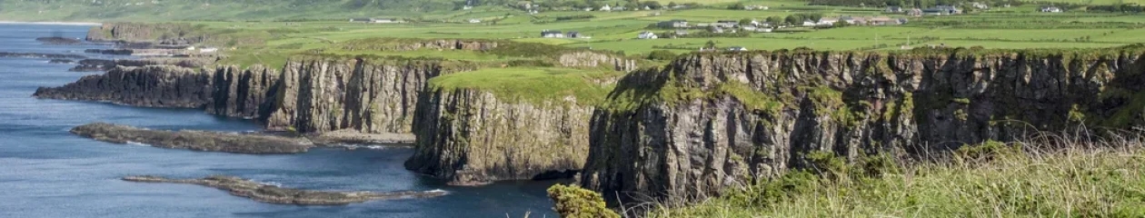


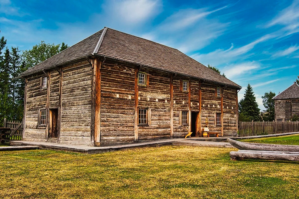


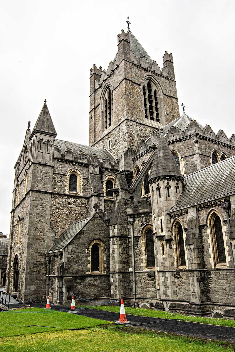
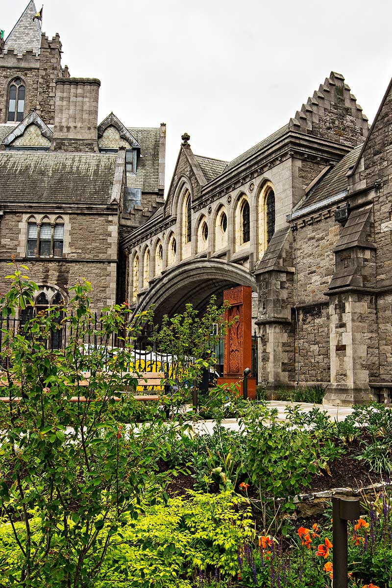
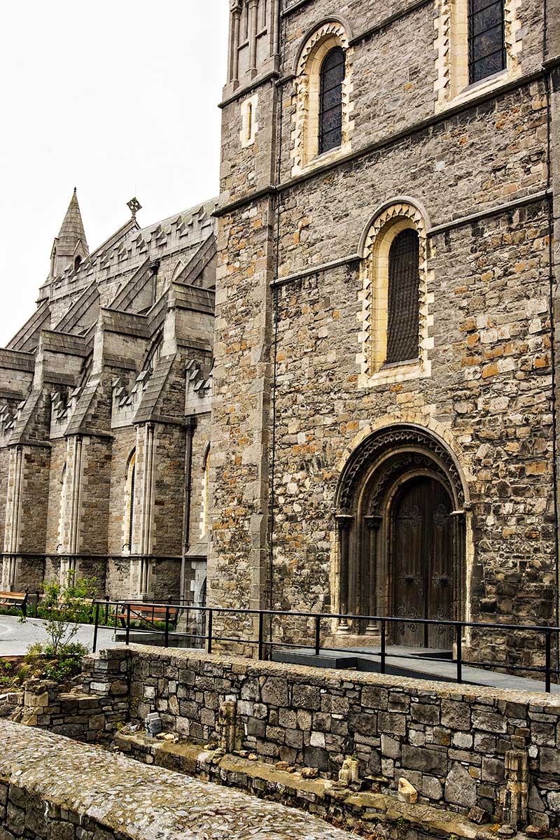
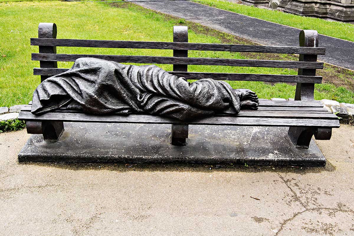
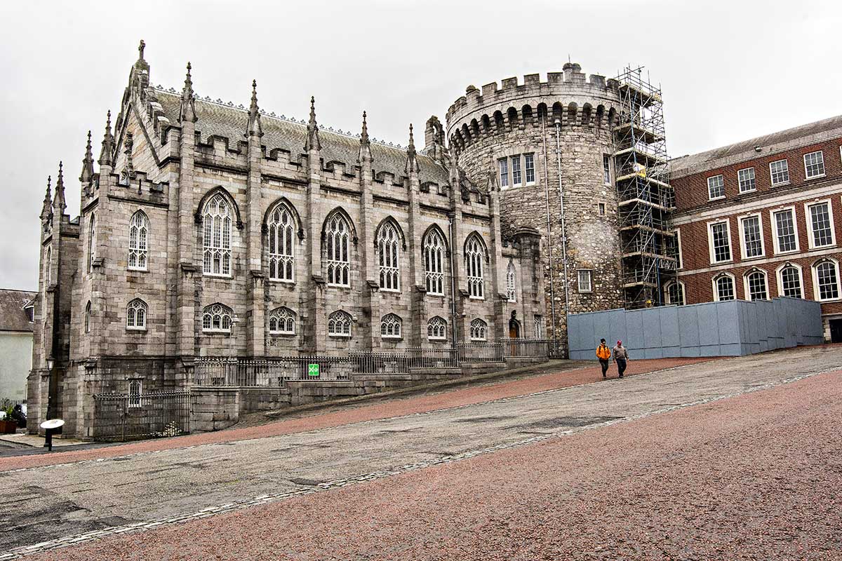
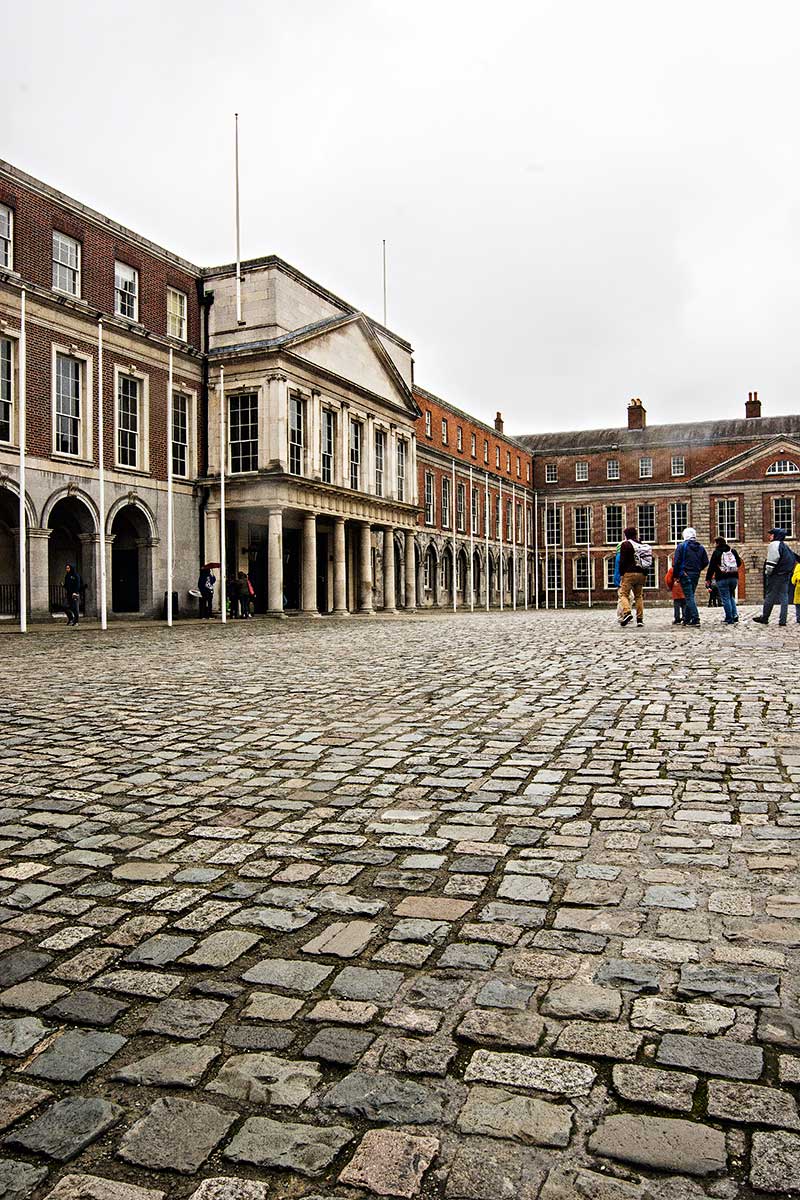
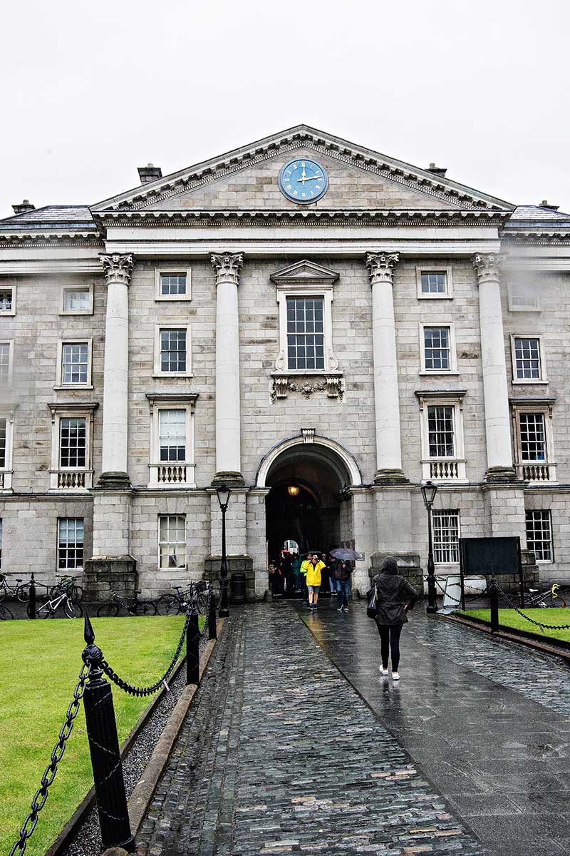
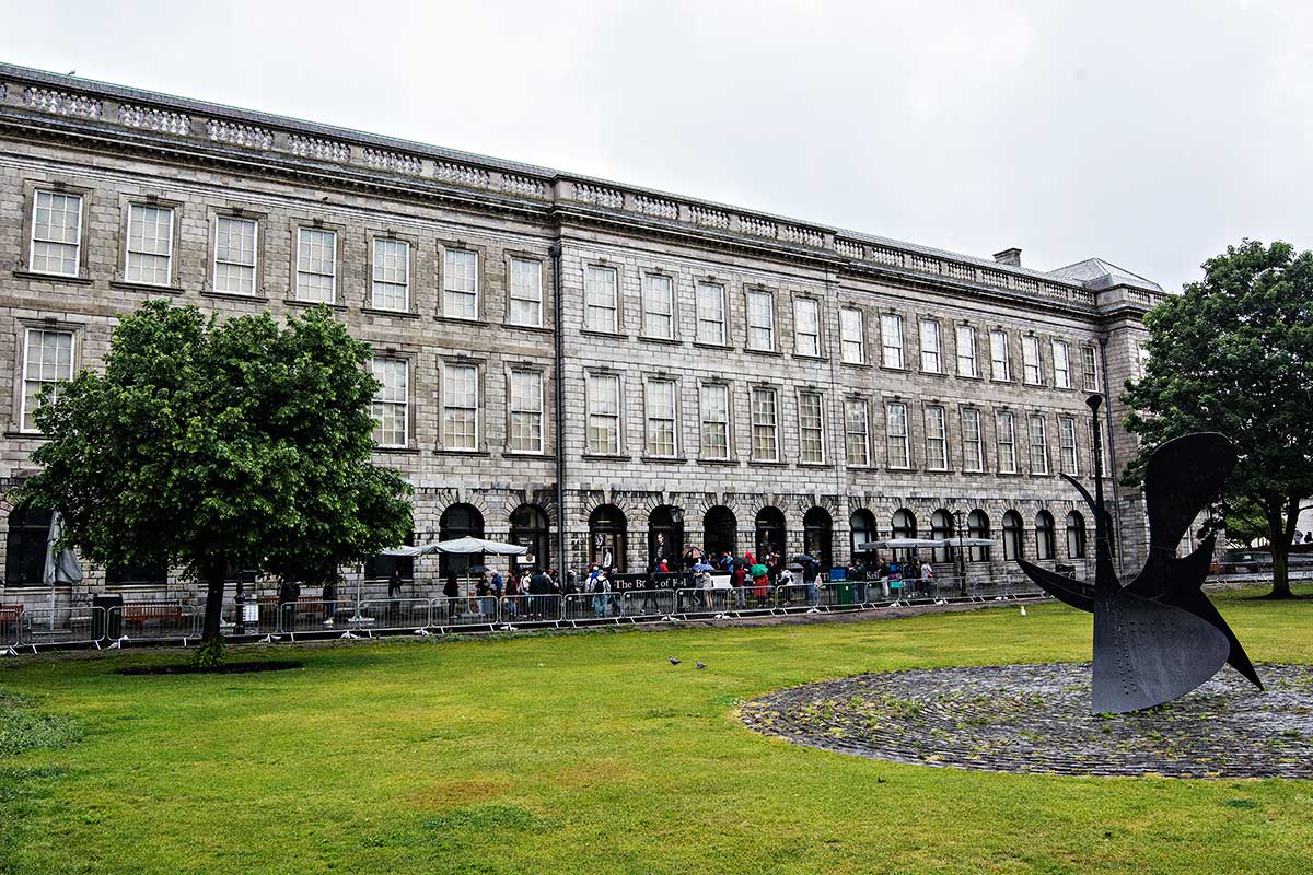
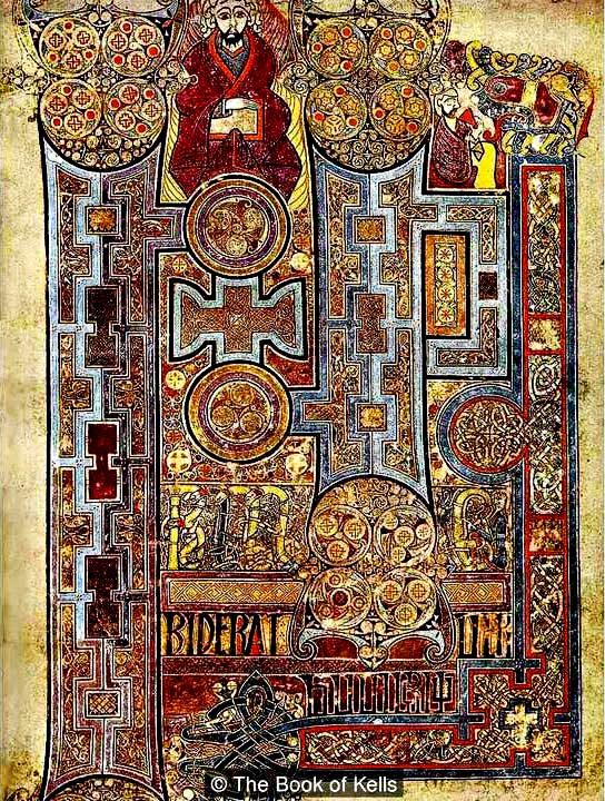
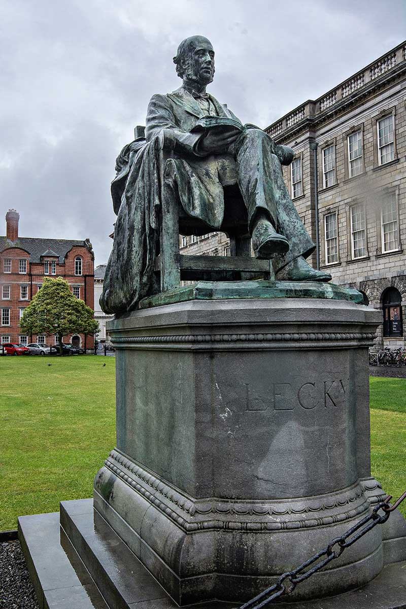
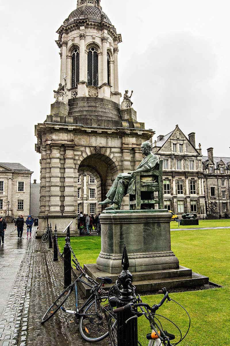
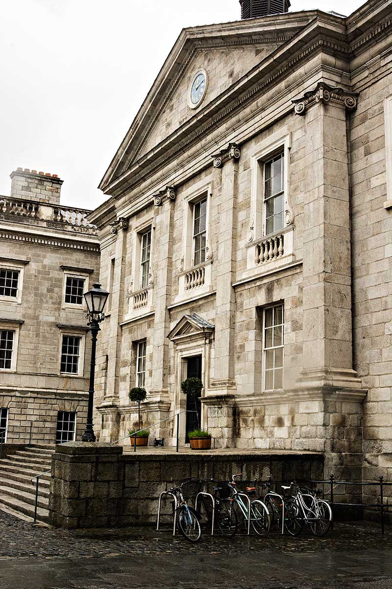
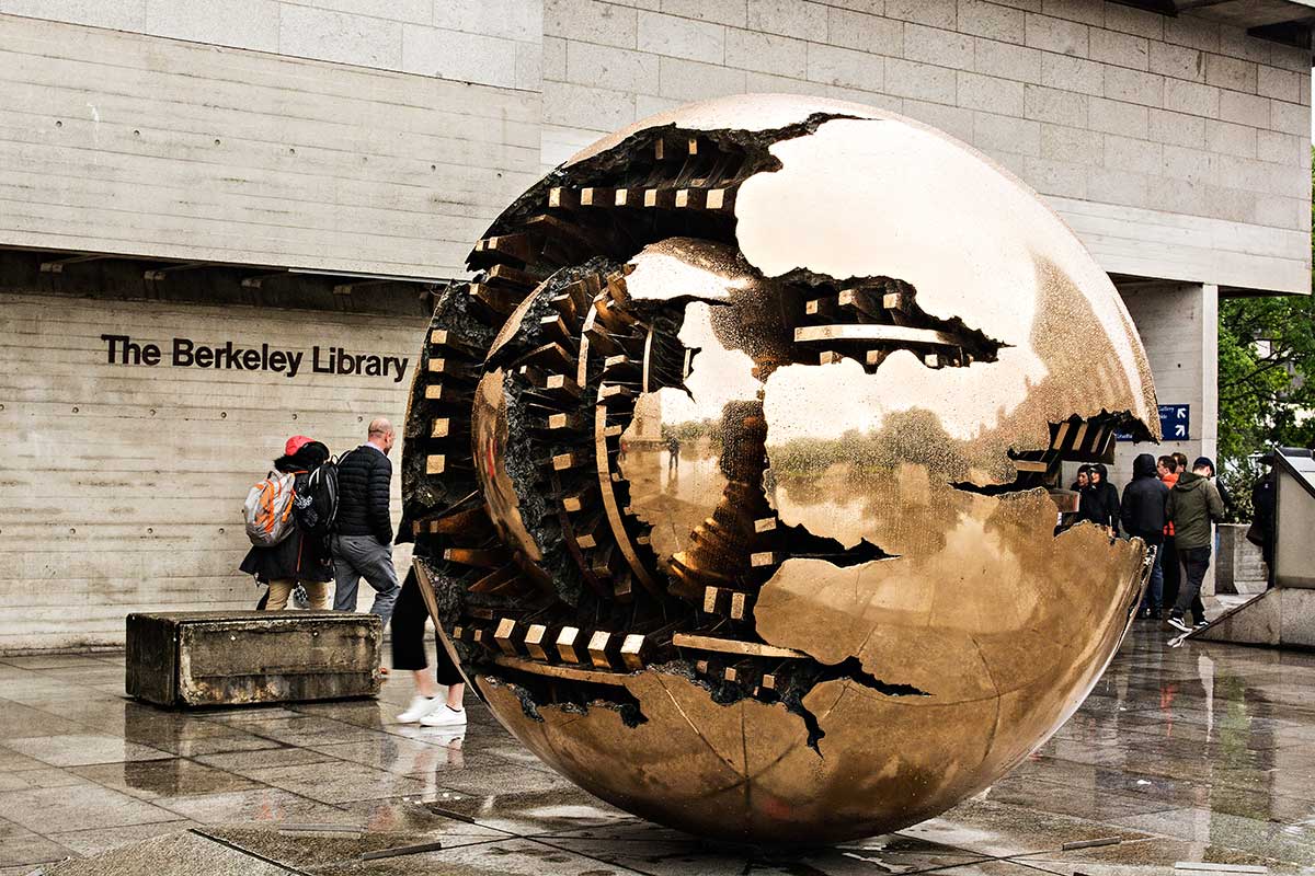
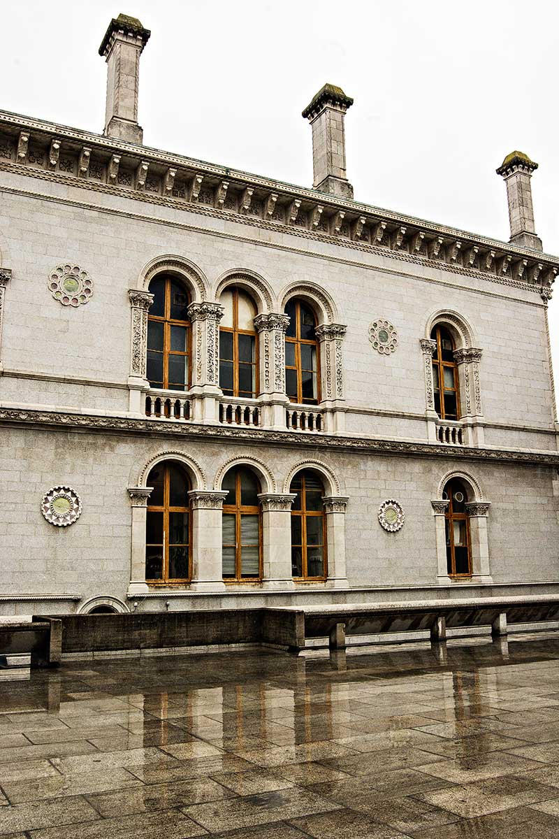
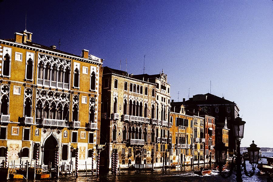
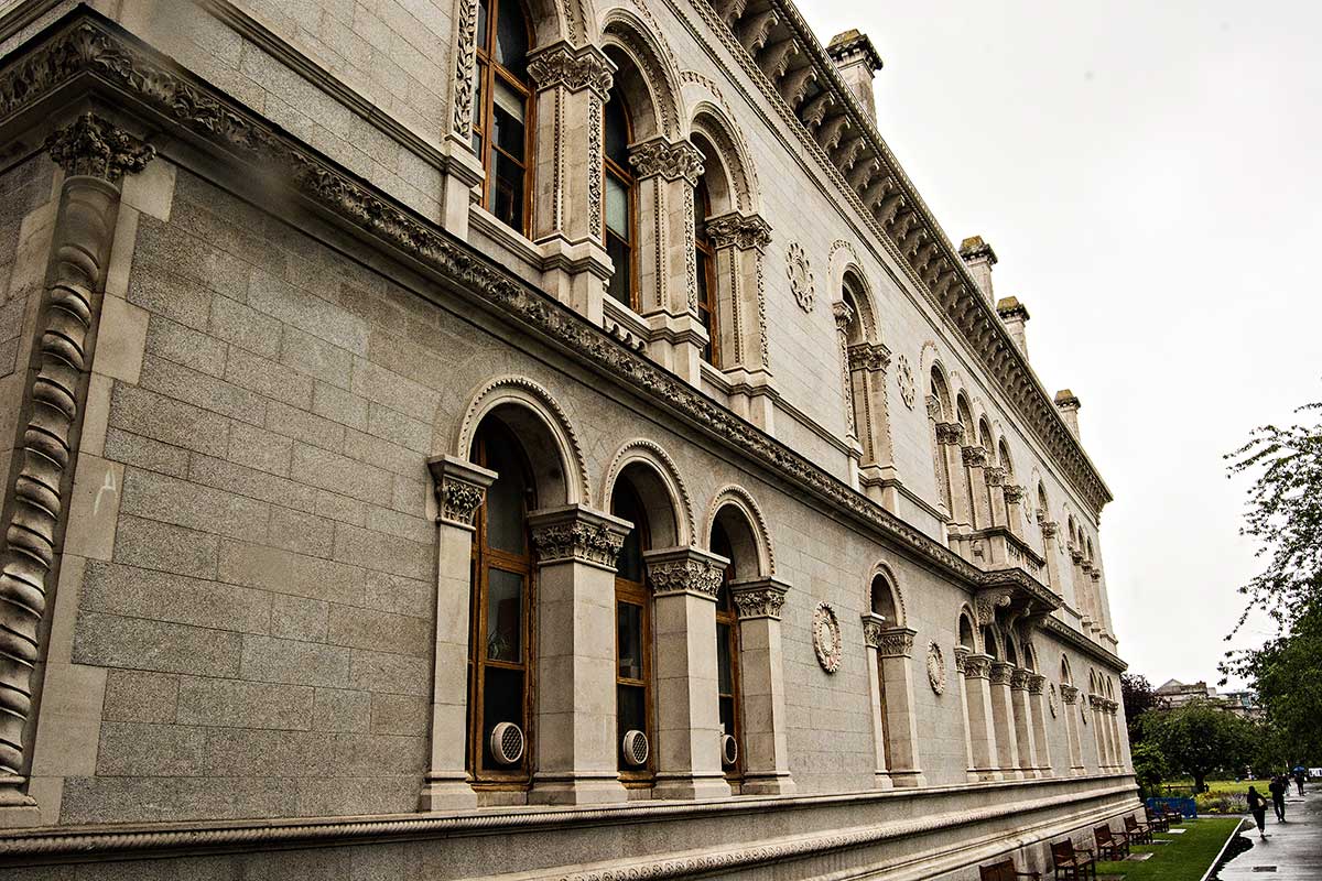
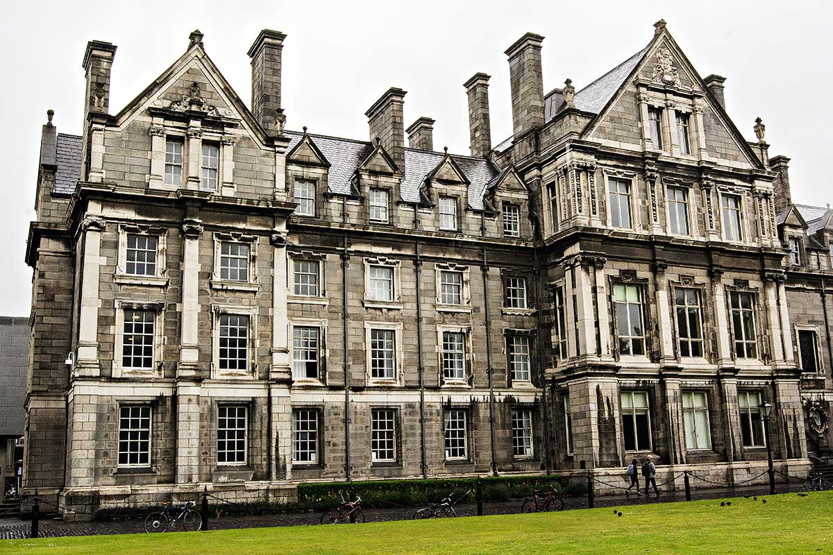
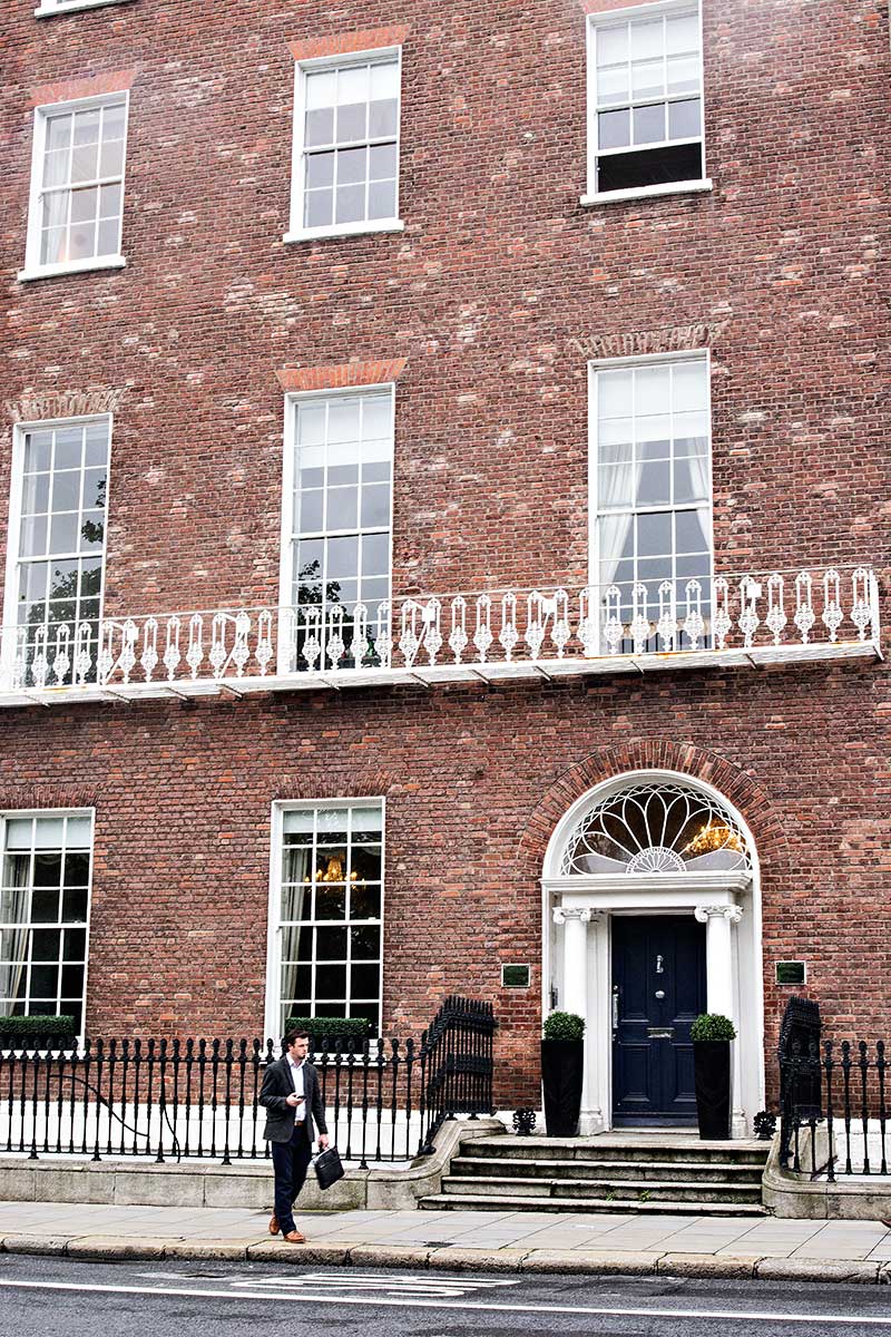
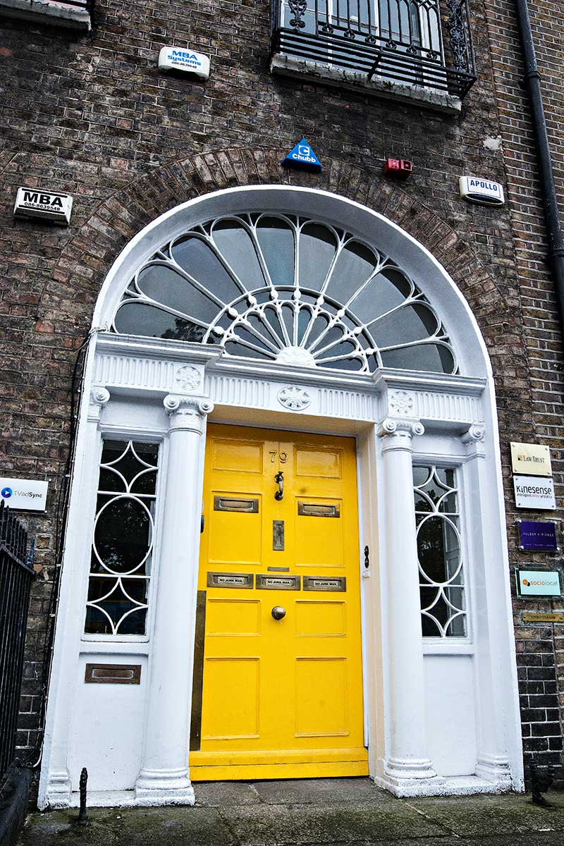
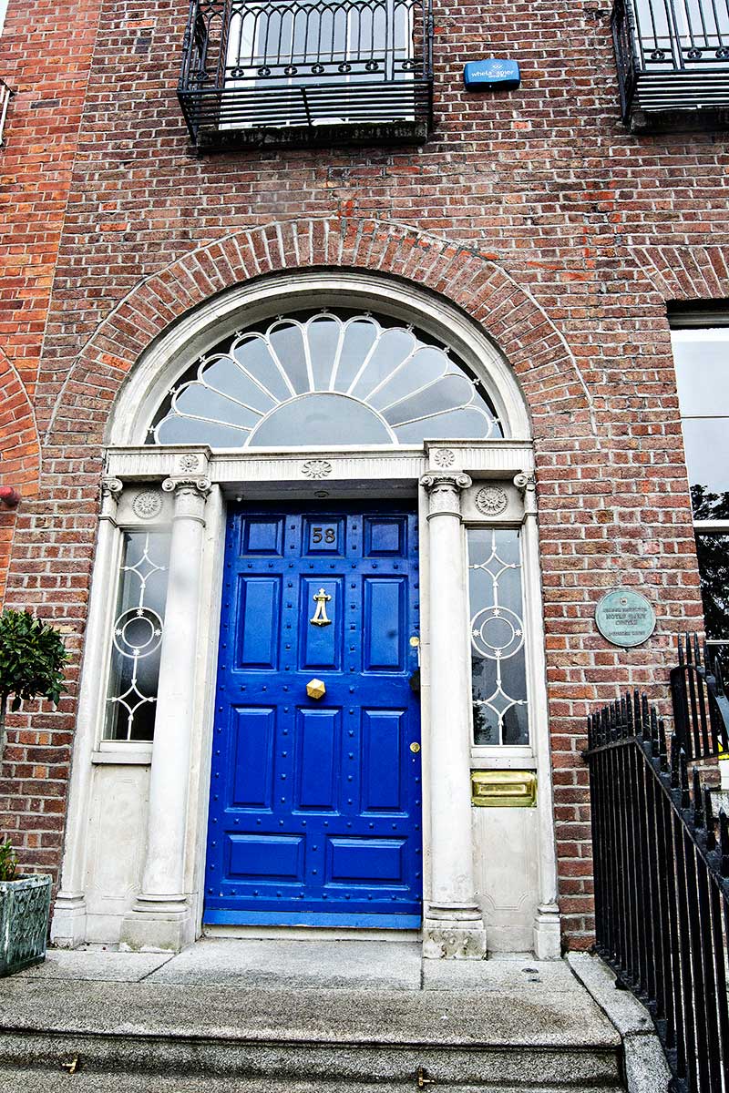
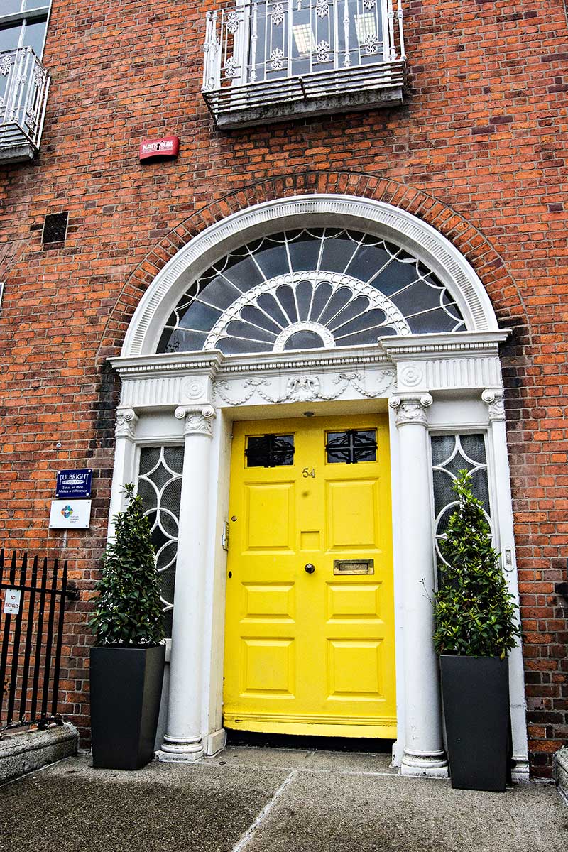


You must be logged in to post a comment.