
What is Quintessential Ireland?
When we travel, we want experiences that are unique to that country. We want to see things that are special. So what is Quintessential Ireland?

Go to the Quintessential Ireland page to see our ideas or add your own.
When we travel, we want experiences that are unique to that country. We want to see things that are special. So what is Quintessential Ireland?
Go to the Quintessential Ireland page to see our ideas or add your own.
Our recommendations are not influenced by affiliate links – we have none. Our content and advice is derived from our personal expertise, experience, and knowledge based on living in Europe for seven years and studying its art, architecture and culture.
Ireland West is the place to see Quintessential Ireland — dramatic cliffs, coastal hikes, golden crescent beaches, airplane-like views, elegant palaces and even a fjord. This route is covered in 7 posts and needs at least 7 days.
The 1Σ to 5Σ Sigma score is our Ireland Itinerary Ratings to indicate how we would rank each place. Please add comments or questions about any place and press the Like button at the bottom of the post!
offers dramatic cliffs, great hike, and lots of tourists — go early or go late in the day. From: Ennis, Lahinch, Doolin, Ballyvaughan, or Galway
offers karst limestone landscapes, unusual formations, flowers, unmarked off-road walks, and Neolithic dolmen (altars). The Burren area is so unusual it probably will be underappreciated by many tourists. Those who love nature will probably rate this higher. You are walking on millions of years of compressed seashells, also known as limestone. From: Ennis, Lahinch, Doolin, Ballyvaughan, or Galway
offers pine lake reflections, spectacular Gurteen Bay and Dog’s Bay crescent-shaped beaches, an easy hike between these two beaches, White Strand beach, and Sky Road Loop. From: Galway, Roundstone, or Clifden
offers wide open views, rugged mountains, Victorian mansion, gardens, fjords, red rhododendrons, and dramatic mountain passes. From: Galway, Clifden, Cong, or Leenaun
spend a day in the city of Galway with wood and marble cathedral, speciality shops, pedestrian and riverside walks. From: Galway
takes a peak at an abbey ruin in a river park, and an luxurious castle hotel for guests only. From: Galway, Cong , or Leenaun
offers broken towers, pirate queens, coastal roads and gorgeous beaches. From: Westport
We spent 8 days as we allowed an extra day in case of rain. You may want a couple of days before and after this itinerary for 9 Perfect Places for Dabbling with Dublin and/or Staying Trim. Trim is an excellent base to use to reach Dublin airport.
This post answers questions such as:
Our recommendations are not influenced by affiliate links – we have none. Our content and advice is derived from our personal expertise, experience, and knowledge based on living in Europe for seven years and studying its art, architecture and culture.
Ireland South is a must to experience Quintessential Ireland — heart-pounding mountain roads, dramatic cliff and coastal views, golden crescent beaches, exotic gardens and lots of walking options. This route is covered in 5 posts and needs 5 days and is ideal for short trips. We spent 7 days as we allowed extra days in case of rain but we had solid sunshine.
The 1Σ to 5Σ Sigma score is our Ireland Itinerary Ratings to indicate how we would rank each place. Please add comments or questions about any place and press the Like button at the bottom of each post!
so spectacular it could be 6Σ. It offers views of mountains, lakes, meadows, and a very dramatic switchback road. From: on the way to Kenmare
offers coastal views of sandy beaches, offshore islands, emerald pastures, rugged cliffs, and spectacular panoramas. Ignore the negative comments about too many tourists. If you do not want crowds, do NOT go in July-August and do NOT go to Killarney. The Real Ring of Kerry is along the coast and is definitely worth going. From: Kenmare
offers distant views, a waterfall walk, castle ruins, Victorian mansion and spectacular rhododendron gardens in May. Killarney NP is not unique to Ireland and the views are not spectacular. Killarney is pleasant but overrated: If you do not want “they paved Paradise and put up a parking lot” then do NOT go to the town of Killarney. We used the really nice village of Kenmare as our base. From: Kenmare
is magical: it offers gardens, exotic plants, and an OPW Victorian house tour. If you get on the first boat you have the island to yourself for one hour — at least in May. There were not that many flowers; it’s more for the grounds and the buildings. From: Kenmare
Slea Head Drive near Dingle is so spectacular, it could be 6Σ. Unlike the Ring Roads, this is a true coastal road that literally goes along mountain sides with spectacular views, amazing beaches and easy walks at Dunquin Harbour and Clogher Head. It ends at the amazing 7th century Gallarus Oratory. If it’s sunny do Conor Pass as well. The next day could be rainy — it was for us! This was such a full day, we did not even have time to explore the really nice town of Dingle (so that would need another day). From: Dingle
You may want a couple of days before and after this itinerary for Rock of Cashel and/or 9 Perfect Places for Dabbling with Dublin and/or Staying Trim. Trim is an excellent base to use to reach Dublin airport.
If you have more than a week, then combine this with all or parts of the Ireland West itinerary.
This post answers questions such as:

Derry is a large city with a compact tourist area surrounded by the only walled city in Ireland and the last one to be built in Europe. It is also the place to connect with the causes and events of the Troubles. Unless you were born after 1998, you were immersed in the problems and violence of Northern Ireland (NI) vicariously through the news.
Our recommendations are not influenced by affiliate links – we have none. Our content and advice is derived from our personal experience and knowledge based on living in Europe for seven years and studying its art and architecture. All the places recommended in this post are pinned on our Ireland North Map. The place names are appended with the Google Maps Rating (G0 to G5).
We drive for a second time to Derry after a marathon forced us to go Ambling the Antrim Coast the previous day. We were looking for the border of Northern Ireland. But there was no indication we were in another country. An open border was a condition of the Good Friday 1998 peace accord. So what will they do with Brexit?
Finally, 40 km from Ramelton, there was a sign in miles. It is like there is only one Ireland. One of our B&B hosts said it will take two more generations before the old timers disappear and replaced by a younger generation that has known only peace.

The modern day story actually begins when Catholic Jacobite forces attempted to seize the town in 1688. This was foiled by 13 apprentice boys. They were orphans from the Great Fire of London (1666) that were shipped to Derry. The apprentice boys grabbed the keys to the city and closed the gates.

The siege became an icon of Ulster Protestant culture. Since the 19th century, the Apprentice Boys Society held two annual parades one on 7th December to celebrate the closing of the gates and on 12th August to celebrate the lifting of the Siege of Derry. The Apprentice Hall above was built in 1873 for this Protestant organization. The Orange Order was established in 1795 to unify the various Protestant factions.

Walk up the stairs for some good views from the walls. King James II came here with his army in 1689 and asked Derry to surrender. They fired their cannons. This was an act of rebellion and the siege continued for 105 days!
The Catholic James II was in Ireland because he was deposed as King of England the previous year by the Protestant Prince William of Orange, a Dutch noble. What we did not know was that William was James’ son-in-law!! I wonder what James’ daughter thought?
But this was only indirectly about religion. The real cause of the war and the later Troubles was political. James was supported by his cousin, Louis XIV of France! William had organized a multinational coalition to oppose French aggression. The real purpose of the coup was to deny Louis XIV a strong ally in Britain. For more on the Battle of the Boyne, see the Neolithic Newgrange post.


In 1600, Henry Docwra invaded pre-Derry and tore down the already ruined cathedral. Henry laid down the streets and is considered the founder of Derry. He used the stones of the cathedral to build the walls of the fort.

The present day Gothic style St Columb’s Cathedral was actually built in the Baroque Era (1633).

Do the whole walk along the walls. You get many views and a whole different perspective

It is not long and you never know who you may meet. Here is a nurse from 1917 who talked about World War I to a large school class.

St. Augustines looks like a 13th century Gothic church but was built in 1872 on the site of St. Columba’s Monastery (542).

The chapel does not face east because the original monastery faced northwest in order to fit onto the hill surrounded by oak trees. St. Columba did not want to cut any oak trees down. The city was was named after these oak trees, which is also the symbol of the city.

The current church follows the same orientation. As a result the entrance is right off the western walls. The entrance has some nice flowers including this white anthurium, the first time I have ever seen.

Back at Bishop Gate, look down Bishop Street. Yes there really was not much traffic. So it is a pleasant walk down to The Diamond with Guildhall in the distance.

Established in 1830, Austins was the world’s oldest independent department store. The original store was destroyed by fire. The current building was built in 1906 on Diamond Square. It has an Edwardian-style baroque facade. The store was closed in 2016 due to asbestos.

The original 17th century city hall occupied the Diamond Square. This beautiful building was built in 1890 in Beaux Arts style — a combination of French neoclassical, Gothic and Renaissance styles.

It has the distinction of being the most bombed building during the Troubles. It cost a mere £19,000 to build, but this is dwarfed by the £8 million spent on recent restorations.

Head to Lecky Road and when you find the Free Derry wall you have arrived at Bogside. This historical landmark is a free standing wall that used to be attached to a row of homes. It commemorates a self-declared autonomous nationalist area of town from 1969 to 1972. Not only have the barricades come down but this area was demolished to build the Lecky boulevard.
The murals provide a visual history much like frescoes in a church. Dating from 1994, they were painted by brothers Tom and William Kelly, and their friend Kevin Hasson. These images are dramatic, powerful, and superb art.
Refugees from the Potato Famine (1845-49) fled to Derry to find work during the Industrial Revolution. They settled in this boggy side of the city. In more recent ties, working class Catholics remained concentrated in the overcrowded Bogside, below the western wall. In the 1960s, Catholics protested peacefully for civil rights and a fair share of jobs. The NI government favoured the Protestant areas in terms of job opportunities.
The Protestant Unionist politicians isolated the Catholics in a small number of electoral wards. Even though the Catholics were in the majority in Derry, severe gerrymandering meant that Unionists controlled the city government. Thus, the Catholics were marginalized much like the Blacks in America.

This mural is a scene from the Battle of the Bogside in this area of Derry in August 1969. This is a young boy wearing a gas mask to protect himself while he holds a petrol bomb.
Unfortunately, the protests were met with violence. The Troubles conflict began in Derry with the Battle of the Bogside in 1969.

Bernadette McAliskey, a social activist, is addressing a crowd during the Battle of the Bogside. She received a prison sentence for initiating and participating in a riot. Bernadette would later be elected to parliament at the age of 21.
By 1971, the level of violence across NI was such that the government introduced internment without trial. However, internment was applied predominantly to republicans.

30 January 1972 became known as Bloody Sunday around the world. British soldiers shot 28 unarmed civilians during a protest march against internment — 14 people died.

You will be able to seem some of the murals as you walk along the western wall of Derry. British snipers used to fire from the wall. Fourteen year old Annette McGavigan was killed in 1971 at a place very close to this mural. A British soldier killed her while she stood at the side of the road. In total, 3,000 people were killed during The Troubles. The large butterfly was painted afterwards as an empty silhouette as they were not sure th peace process would succeed. In 2006 it was filled with colour and symbolizes the hope for peace.

The Saturday Matinee depicts a riot scene that became common on Saturday afternoons in the Bogside between 1969 and the early 1970s.

This mural show a young boy running from the tear gas. Two young teens are shown at the bottom. They were killed by British sniper fire and IRA bomb respectively.
This artwork showcases the struggle for democratic rights for both Protestants and Catholics. These early marches through the streets were inspired by Martin Luther King’s civil disobedience campaigns.

The Peace Mural is a dove emerging from an oak leaf. The dove is a symbol of peace and Derry’s patron saint, Columba. The oak leaf is a symbol of Derry. The background is a set of equal-sided squares, which represents the equality of all citizens. On this colourful note, let us hope for a peaceful and prosperous future for Derry.
Ireland’s Best Sights — the top eight drives in Ireland
Ireland FAQ answers your questions such as when should I go, what is the best clothing, how much time do I need, how safe is Ireland, should I pay in Euros or my own currency, et al.
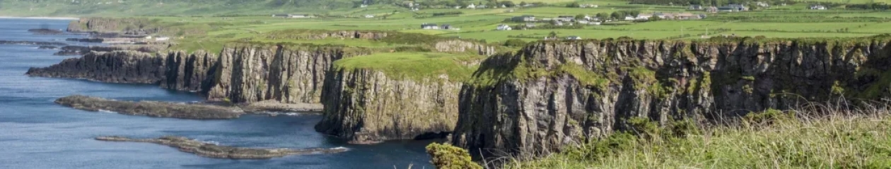
The Antrim Coast has some of the nicest coastal scenery as well as the most exciting hike in Ireland. But you need to get off the Antrim Coast Road, which is neither on the coast not as scenic.
Read on to find out how to make the most of your time —decide which places should you visit, see which photos fascinate you, as well as get links to our custom Google maps and itinerary planning information.
Our recommendations are not influenced by affiliate links – we have none. Our content and advice is derived from our personal experience and knowledge based on living in Europe for seven years and studying its art and architecture. All the places recommended in this post are pinned on our Ireland’s Best Sights Map. The place names are appended with the Google Maps Rating (G0 to G5).
Today did not start well. As it was cloudy and 30% chance of rain, we drove from Ramelton to see Derry. But there was a roadblock. Our offline Maps.me could not handle the change quickly. But continual roadblocks prevented us from going to the centre of Derry — people were running a marathon! So I made an executive decision — okay, we made an executive decision. We switched to do the Antrim or Giant’s Causeway Coast. We were glad we did! All’s well that ends well.

This pull off was one of the few views “along the coast”. The view is the Inishowen Peninsula across Lough Foyle.
“The Antrim Coast Road is often praised as Ireland’s most scenic drive.” This is highly debatable. The road does not even travel along the coast.
You need to get off the road to see views and do hikes. Many sites require high fees. Some places are very overcrowded and the traffic is more aggressive than in the Republic of Ireland. We would hate to drive here in the summer!

However, it is definitely worth driving and there are gems that you can enjoy. We got off Highway A2 at the Sea Coast Road (B69). It is a smaller road that goes through farmland but has some interesting mountain backdrops. I believe this is Binevenagh.

We stopped for a photo at Crindle Stables at the Carrowclare Road intersection. I noticed a slew of horses. I softly whistled and called them in my mind to come over.

And they did come over — right to me and shoved their heads over the fence inches away from me! It was surreal. I thought they wanted me to touch them. After the experience at the Portacloy Peat Farm when the farmer said not to pet his three-year old pony because he bites, I chickened out and took their photos instead.

Benone Beach was a huge expanse of beach spoiled by cars and food trucks parked all over the supposedly Blue Flag beach. Blue Flag Organisation is an international body aimed at promoting environmental awareness and sustainable development of areas of natural beauty. I’m sorry but IMHO car parking on a beach automatically disqualifies the beach as an area of natural beauty.

But it is such a nice beach. Pity! We rested here while the skies gradually cleared.
So what makes a beach spectacular? It is the same visual elements that make great art or photography: texture, depth, colour and curves. Headlands, cliffs, and formations provide texture and depth. S-curves or serpentinata makes beaches and art more dynamic.

You can see Mussenden “Temple” (fake) from far away on Benone Beach or pay €6.20 per person to the National Trust to see it up close. Just down the road, we found out the price also includes the Downhill Demesne, which has gardens and the ruins of an 18th century mansion.


The 1784 Bishop’s Gate

Next we drove to Port Stewart Strand, which charges €8 per car (National Trust) to go to a beach you cannot even swim in (too cold). It is also spoiled by cars parked all over the beach. There is a nice view from the hill above the beach. But is it worth going? The beach is long but straight. The water does have some beautiful turquoise colour.

In fact, avoid over-touristed Port Stewart and Port Rush altogether unless you prefer urbanization to nature. This is an example of Joni Mitchell’s classic song Big Yellow Taxi: “They paved paradise and put up a parking lot.” The traffic was horrendous with wall-to-wall cars. We gave up and turned around. Just after Port Rush, there are a few pull offs with nice views of the rugged coastline.

Now comes the great part of this day trip. Drive Highways A2 and B62 to White Rocks and its beautiful beach.

Not only is the beach beautiful and free, the white limestone cliffs were formed 65 million years ago. You are looking at years and years of dead seashells deposited at the bottom of the sea and compressed into limestone.

Next you drive literally on the edge of the White Rocks on the only true coastal part of this road. There are a couple of viewpoints such as this one looking back on the beach.


Another viewpoint looks towards Dunluce Castle.

But the best view is right at Danluce Castle. There is a charge to visit the ruins. Otherwise, walk from the parking lot through the low wall and turn right for a superb photo opp.

The roads in Northern Ireland are very good. In contrast, tourist sites are poorly organized. The biggest hassle was getting into or out of the Dunluce parking lot. There are two entrances, one on west side and one on the east side. Cars are parked along these roads making them effectively one lane roads. But cars are going both ways. There was a traffic jam trying to get out! This could be fixed for the minimal cost of a sign. Why oh why do they not make this a one-way road going west to east?
Next is the famous Giant’s Causeway. They claim that all national parks are free but you have to park. The choices are the NP parking lot for an extravagant £12.50 per person “parking” fee or free along the highway IF you can find a place. There was no parking to be had so we continued east expecting to try again on the way back. We were there just after the peak visiting time from 11:00 to 15:00 hrs.

We drove to the Dunseverick Castle ruins further east on the coast. The ruins above are not special.
However, Dunseverick Castle is the trail head for the 7.7 km Giant’s Causeway Trail. National Trust warden, Toby Edwards, claimed this is the best hike (and coast). It was time to find out if he was biased?

Some web articles stated that the Dunseverick part of the trail was unexciting. So I wasn’t sure how far I would hike. This was the initial view after the picnic area behind the house where we parked.

After a mere five minutes I was hooked. I had the place all to myself — there were a total of five other hikers including a nice Dutch couple I spoke with for quite a while, as we covered a wide range of topics from hiking to politics.

Actually, you don’t need the highest cliffs or the widest beaches to make a hike good. What makes it special are indented headlands, rocky shapes, and constantly changing, photogenic views.

Yes, the sun lighting up the turquoise coast helped but it also rained. Wait five minutes and the weather changed again. The views were wide open with picturesque green pastures and mountains in the background. The scenery pulled me in and I continued my favourite hike in Ireland — sheer bliss.
It was late in the day so we headed home via the Giant’s Causeway. There was still no space to park. As I had a glorious time on the trail without any people, I didn’t want to spoil the day competing with gazillion tourists trying to take nature photos of basalt with people standing on top of the columns.
Basalt columns are formed when magnesium and iron-rich lava extrudes from the ground near cooling water such as at Svartifoss Waterfall in Iceland, Los Prismas Basálticos in Mexico, and Yukon River, Yukon in Canada below.

Moreover, we had recently gone to Yukon Green where only 36,000 people live in a territory that is the same size as California! I had the basalt-lined, glacier green Miles Canyon Trail all to myself. Oh, and it’s totally free!

It was a dangerous whitewater river when the Klondikers rushed up this river to the famous Klondike Gold Rush (1896-1899) at Dawson City. Unlike in California, the gold miners were well behaved and land claims were controlled by gold commissioners.
Do you want to learn how to plan an itinerary? Is your trip less than two weeks? Use these ready-made itinerary maps to plan your trip.
The following are the nearest places to this drive:
This post answers questions such as:

Enjoy dramatic hikes and spectacular vistas at Horn Head. Feast on delicious ice cream and cappuccinos at the golden sand Marble Hill Bay Beach. Delight in beautiful views of Ballymastocker Beach. This day trip is a series of inland roads with side trips to coastal cliffs, arches and beaches.
Read on to find out how to make the most of your time —decide which places should you visit, see which photos fascinate you, as well as get links to our custom Google maps and itinerary planning information.
Our recommendations are not influenced by affiliate links – we have none. Our content and advice is derived from our personal experience and knowledge based on living in Europe for seven years.

Drive north of Ramelton or Letterkenny on Highway N56 through the karst scenery with rock strewn outcrops shown above. It is similar to the drive near Glenveagh NP due west of here. The rest of the drive to Dunfanaghy was not remarkable.

BTW, you do not drive to the point called Horn Head on Google or Maps.me. You drive to Lookout Point Horn Head on Google Maps or Coastguard Hill on maps.me. The road dead ends here. We got one of the last spots in the tiny parking area and walked up Coastguard Hill.
A light rain was falling. The hazy, blue-grey view above is what we actually saw. But in spite of the haze, we were still blown away by the magnificent vista. Horn Head is certainly the main must-see of the day.

In the photo above, I just added more light, contrast, and reduced the blue haze. The result was better than what I saw when I was there. As you can see, the plateau has plenty of space to walk around in order to take in the 360° view. This is one of the only views of a cliff because you are standing on top of them. So this is very different from the Cliffs of Moher or the Ring of Kerry

After you descend the hill, then turn left and walk past the end of the pavement where the trail begins. Take the short right branch to see the hazy distant islands dotting the exceptional vista.

This trail leads to the second view of rugged cliffs. In this photo, I changed the white balance to get rid of the over the top blue cast.

Return to the junction and head towards the watch tower and cliff you saw from Coastguard Hill.

This trail brings you close to the cliff.

Drive south down the narrow road you came on but turn left to the roadside Discovery Point with wide parking space. Here you get a third view of cliffs.

The road back to Dunfanaghy is quintessential Ireland with emerald green pastures crisscrossed by stone fences and framed by distant mountains.

Dunfanaghy (the g in gh is silent) is the largest town on this route. In the town near the market, pubs and cafes is this small park along the tidal flats. Nearby is Killahoey Beach, a wide expanse of sand.

Marble Hill is a fair sized beach with several photogenic elements of interest. Park along the road near The Shack Cafe. Imagine owning that huge house right off the beach.

Then there are the turquoise waters framed by rocky headlands. But the not to be missed point of interest is The Shack with good espresso choices and the best gelato (Mullins brand) we had in Ireland. It was €3.50 for two scoops. Don’t even bother going to the flavourless and more expensive Murphy’s in Killarney or elsewhere. You can also get better speciality ice cream in the supermarkets.

The castle tower is believed to have been built in the 1420s. Spanish survivors of the 1588 Spanish Armada fleet were sheltered at Doe by the MacSweeney Clan chief.
This is also the scene of Ireland’s own Romeo and Judith. Judith was the daughter of the clan chief, Maolmhuire. She was in love with his nephew, Hugh McSweeney. Maolmhuire suspecting a conspiracy by Hhugh, and swung his staff to kill his nephew. But Judith stepped in the way and stumbled into the well to her death.

The Harry Blaney Bridge (2008) provides a route to the Fanad peninsula. There had been no ferry service since the 1960s. It is amazing that Harry Blaney got the government to pay €20 million for a low traffic bridge.

The white Fanad lighthouse contrasts with the green grass. Personally, I found Fanad overrated. The tourist literature hyperbole reminds me of the Doers and Dreamers Guide back home where everything is painted as great.

The view from the parking lot of the Fanad lighthouse towering over a narrow rocky inlet was the best.

The massive sea cave is viewable through the farm gate on the narrow country road. We assumed that the farm would not appreciate tourists so we did not drive or walk down to see the actual arch on the other side of this headland. But you can see the huge cave cut right through to the sea.
Head south from Fanad on Highway R246 to the tiny town of Portsalon. As you pass the golf course you see one of the nicest beaches of golden brown sand. But there is no access to this beach from the north end where the town is located. Continue on the road to the south end for beautiful Ballymastocker Beach (G4.8) with a large bathroom facility.

The road from Portsalon to a seaside fort 5 km away is certainly the second must-see of this tour. As the road switchbacks up the mountainside there is a place on the left to pull over for a drop dead view.

The three beaches and intervening grasslands were stunning.

This fort with an underground cave marks the end of the most scenic stretch of the road.

Formerly called Rathmelton, this was a bustling port in the 18th century trading with New York and Jamaica. As a result the town is lined with Georgian architecture (1714-1830).

Unlike the port towns of Ireland, most of the buildings were drab grey or white except for the Bridge Bar. Subdued colours is an element of the Georgian style.

A three-arch stone bridge crosses the River Lennon.

Former factories line the quay.

We loved our Victorian B&B in this quiet town of 1266 people. If you want more supermarket, dining, and nightlife opportunities then an alternative base would be Letterkenny, with 19,000 people. But 11 km is an easy commute and we did it every day.
This is an action-packed itinerary where you can get away from the crowds of tourists who head to sites that are famous because of name recognition. The places are all highly rated by the people as shown by the high Google Map Ratings. Remember, the most important “destination” is meeting the people.
What things fascinate you? How long is your trip? What questions do you have? Do you want more information? Then subscribe for free.
Do you want to learn how to plan an itinerary? Is your trip less than two weeks? Use this ready-made itinerary map to plan your trip.
Ireland North’s Best Sights Map
This day trip is part of our preplanned two-week North of Ireland itinerary.
What is the purpose of your trip? What are your interests? This itinerary was based on the features that make Ireland unique…
The FAQ post answers questions such as:

On this drive you can see Quintessential Ireland with white sheep on green hills and stone walls bordering paddocks. Enjoy narrow lanes to isolated vistas of forts and coastlines. Visit a neo-Gothic cathedral and enjoy a meal in Letterkenny. Relax in non-touristy antique Ramelton.
Read on to find out how to make the most of your time —decide which places should you visit, see which photos fascinate you, as well as get links to our custom Google maps and itinerary planning information.
Our recommendations are not influenced by affiliate links – we have none. Our content and advice is derived from our personal experience and knowledge based on living in Europe for seven years.

Today’s route goes from Donegal through back roads to Ramelton close to Northern Ireland. It is day 31 of our remarkable 36-day odyssey to Ireland.

Rain may have dampened our views as the photos on the web certainly show the beauty of Maghery Beach tinged by turquoise waves. Nevertheless, we felt it was just not in the same class as the many other beaches we have shown you before. such as our post Galway to Gurteen Bay.

However, the short trail to the beach was strewn with brown-banded snails.

Parts of the next stretch are narrow as in one-lane. Definitely don’t be put off (there was not much traffic today) as the views are the best.

Driving this road — no, not the one in the photo — made the trip to Maghery Beach worthwhile. There are sheep paddocks with an ocean backdrop littered with jagged rocky islets.
The road comes close to an 1804 watchtower, which can be seen from the beach. Wow, they really feared a Napoleon invasion. Napoleon was actually an ethnic Italian from Corsica. He won almost every battle he fought and became a general in the French army at 24! 1804 was also the year Napoleon became emperor of France. He was finally defeated at the Battle of Waterloo in 1815.

However, his Napoleonic Code lives on as the foundation of the legal system of 1/4 of our planet. It championed the basic tenets of the modern world — meritocracy, equality before the law, property rights, religious freedom, abolition of feudalism and consolidation of jurisdictions. Ironically, the latter facilitated the unification of Germany in 1871. We can thank Napoleon for the metric system. The originally, unpopular metric standard was enforced throughout all of Western Europe conquered by Napoleon.
The road to Crohy Head Sea Arch went through verdant pastures. There were no signs. Most of the pasture fences were locked so we assumed farmers did not want tourists traipsing through their properties. It is debatable whether it is worth doing this stretch of the road.
We retraced our steps north to Dungloe. The road was uneventful until the Bloody Foreland viewpoint. This name did not originate from a bloody battle but from the intense red hue of the rocks at sunset. In this area Irish is still the dominating language.

The most important target scenery of today, Mt. Errigal, was hidden by low flying clouds. We stopped at the Dunlewey and other viewpoints but bubkes.
Glenveagh NP was too wet to go hiking and the buses and tours to Glenveagh Castle were full as this was a holiday weekend.

The Cathedral opened in 1901 and is built in Victorian neo-Gothic style on a site overlooking the town. Unfortunately, too many overhead wires and chimneys block the views of the surrounding grassy hills. While the style is old, the cathedral looks new. That is no wonder since in 2001 the sandstone exterior was cleaned and the stone was repointed.

The cathedral is furnished with a marble pulpit by the Pearse Brothers of Dublin. The pulpit depicts statues of the Four Masters, the same friars that are honoured by the Church of the Four Masters in Donegal.

The original altar-piece, an Irish carving of Leonardo‘s Last Supper, was incorporated into the new altar.

The Rabble Children monument was created (1994) by Maurice Harron, a Northern Irish sculptor from Derry. Hiring fairs were held in Letterkenny in years gone by when children between the ages of 11 and 16 were sold for periods of six months to wealthy farmers of the Lagan Valley. It is shocking how children are treated. A Google search found that there is a Rabble.ca organization in Canada that champions the rights of children.
Rabble Days were held annually in May and November at the corner of Speer’s Lane and Upper Main Street. Letterkenny is the main market town even today. So we took advantage before heading to tiny Ramelton.

Once again we stayed at a superb B&B — I think all of our B&B choices in Ireland were very good. This one was located along the river on the outskirts of town.

We stayed three nights at this historic Victorian house built in 1845. It was the home of Catherine Black, the nurse to King George V. Both the living and dining rooms are furnished with antiques, paintings and family photographs.
This is tranquil day trip where you can get away from the crowds of tourists and visit areas not well known.
What things fascinate you? How long is your trip? What questions do you have? Do you want more information? Then subscribe for free.
Do you want to learn how to plan an itinerary? Is your trip less than two weeks? If you have less time simply quit the itinerary at Ramelton, Donegal or Sligo and return to Trim, departure point for the Dublin airport. Use this ready-made itinerary map to plan your trip.
Ireland North’s Best Sights Map
This day trip is not part of our preplanned two-week North of Ireland itinerary. It could be added to this itinerary if you have more time.
What is the purpose of your trip? What are your interests? This itinerary was based on the features that make Ireland unique…
The FAQ post answers questions such as:

Admire the turquoise water lapping the Silver Strand beach. Enjoy spectacular vistas at Slieve League cliffs — if it isn’t fogged in. Feast on delicious cappuccino and pastry in Killybegs. Explore the stone buildings and castles of Donegal. Delight in the stone round tower of the Church of the Four Masters.
Read on to find out how to make the most of your time —decide which places should you visit, see which photos fascinate you, as well as get links to our custom Google maps and itinerary planning information.
Our recommendations are not influenced by affiliate links – we have none. Our content and advice is derived from our personal experience and knowledge based on living in Europe for seven years.
Slieve League, one of the best cliffs in Ireland, was supposed to be the highlight of day 29. Instead, it was pouring rain so we first drove around Donegal, a small town of 2600 people. You can see this route on our Ireland North Itinerary Map.

Donegal means fort of the foreigner (probably the Vikings). The 15th century keep was the stronghold of the O’Donnell clan, one of the most powerful Gaelic families in Ireland from the 5th to the 16th centuries. They rule all of the County Donegal to Derry and parts of other counties as well.

Continue east on Tirchonaill St. across a bridge with a good view of the town east along the River Eske. In the distance, a church with a round tower caught our eye so we drove to find it.

Church of the Four Masters was built in 1935 using granite. It commemorates the Annals of the Four Masters, a medieval history of Ireland written by four Franciscan friars. The Church was built in Irish Romanesque style with a semi-circular door.
Round towers are free-standing bell towers similar to campanile in Italy, where we lived for four years. This architecture began in the 4th century in Italy. Campana in Italian means bell. The most famous campanile in the world is the Leaning Tower of Pisa, which is also round.

Other interesting buildings are the Castle and the Old Castle Bar as seen from Bridge Street.

The Diamond square (actually it’s a triangle) is the centre of Donegal. The Market House Restaurant is one of the interesting stone buildings.

It was time to drive the N56-R263 Loop to Malin Beg. The road is basically inland until Killybegs Harbour. We took a photo of this major fishing port.

We walked into the McLoone deli-bakery, which also sells lunches and some neat pastries. Then we stopped in at Ahoy Café for some great cappuccino and pastry — it was so good we stopped again on the way back!.

From here we drove all the way to Malin Beg where there was a great high up viewpoint. Above is what the scene really looked like — 50 shades of dreary and dismal grey. We stayed for quite a while, eating our lunch. Then the rain stopped and a new round of photos were taken.
No it did not suddenly get sunny. Back at home, through the magic of Photoshop, we can now see just how beautiful this beach scene can be. Turquoise water laps the golden sand. Perhaps it should be renamed Turquoise Strand.

This is the view to the right side.

This must be spectacular on a sunny day! OK, now back to reality…

A steep staircase leads down to Silver Strand. Are you ready for your workout?
There is one thing worse than rain for photography — unrelenting fog. We left Slieve League for the end of the day but while the rain had slowed, the poor visibility did not. So we saw bubkes. Although less famous than the Cliffs of Moher, Slieve League is almost three times higher.

I even hiked up the trail just a bit but all I could see was the stone stairs. I knew from photos that there was a sheer drop off on the other side of the fence along the trail.

On the plus side there was a cute pub in the Tiny village of Teelin (Tí Linn). Beside the traditional atmosphere, The Rusty Mackerel has a large amazing monochrome mural commemorating local traditional musicians.

We returned to the warmth of our Gap Lodge B&B (G4.7) with its cozy breakfast nook.
This is a pleasant day trip in Donegal without many tourists. Remember, the most important “destination” is meeting the people.
What things fascinate you? How long is your trip? What questions do you have? Do you want more information? Then subscribe for free.
Do you want to learn how to plan an itinerary? Is your trip less than two weeks? If you have less time simply quit the itinerary at Ramelton, Donegal or Sligo and return to Trim, departure point for the Dublin airport. Use this ready-made itinerary map to plan your trip.
Ireland North’s Best Sights Map
This day trip is part of our preplanned two-week North of Ireland itinerary.
What is the purpose of your trip? What are your interests? This itinerary was based on the features that make Ireland unique…
The FAQ post answers questions such as:
Our recommendations are not influenced by affiliate links – we have none. Our content and advice is derived from our personal expertise, experience, and knowledge based on living in Rome for four years and studying its art and architecture.
One of the unique features of Italy are the free-standing towers called campanile. The Italian word campana means bell. I wonder how may tourists appreciate that the famous towers are always bell towers associated to churches or monasteries? What is unique about campanile in Italy is that they are built as works of art and architecture.
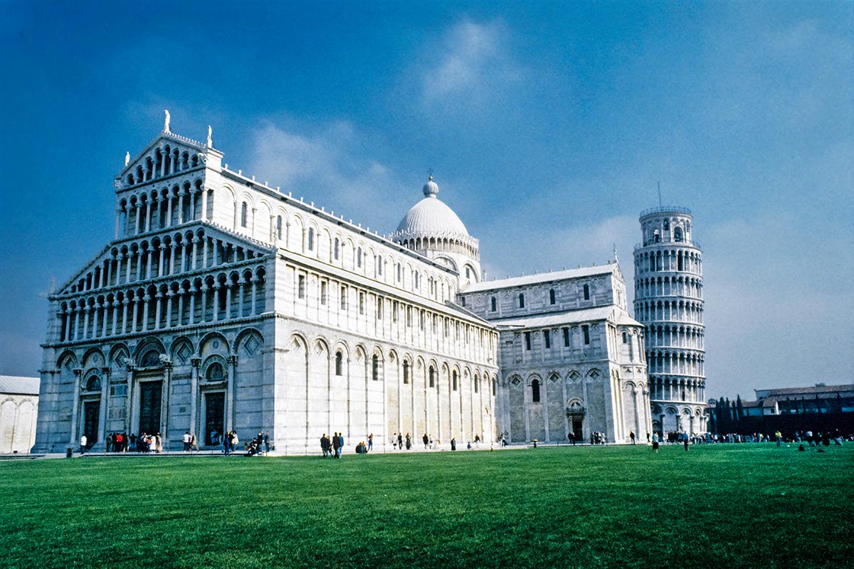
The Leaning Tower of Pisa is the campanile of the Cathedral of Pisa. The tower built in 1178 was already leaning due to the weight of marble on the unstable soil. But the soft soil also protected the tower from being toppled by four major earthquakes. Recent projects have decreased the lean from 5.5% to 4%.
The tower may look like classical architecture but it is not. The campanile was built in the Middle Ages using the popular Romanesque style, which was based on Roman classical architecture. The Leaning Tower is also famous for Galileo dropping two cannonballs with different weights to prove that mass does not affect the speed of descent.
We are fortunate that the Leaning Tower still exists. During World War II, a US Army Sargent refused to order an artillary barrage against the tower where Germans were firing.
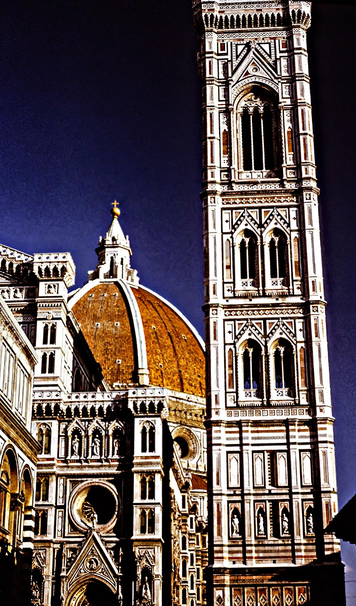
The Duomo is the name of the Cathedral of Florence, the first dome raised since Ancient Rome. Even though this building was started in the Middle Ages, it is considered the birth of Renaissance architecture.
The Duomo Campanile (1334) was built by one of the most famous medieval painters, Giotto. The 84.7 m. (277.9 ft) tall tower is in Gothic style. However, instead of an austere design, Giotto incorporated white, green and orange-red marble inlay to match the style of the Duomo.
The famous tower near Basilica San Marco (1174) in Venezia is a campanile. It was frequently damaged by lightning and an earthquake in 1511. It totally collapsed in 1902 and was rebuilt. The 98 m. (323 ft) brick tower is on an unstable, waterlogged base and is under repair right now.
The Fall of Rome led to the Rise of Venice. Venice was the major European power other than Constantinople during the Middle Ages until the Renaissance. Venezia ruled the sea, controlled all trade between the Silk Routes and Western Europe, ruled the Adriatic as well as the Greek Islands in the Mediterranean.
The tower was copied in the Venetian colonies of Slovenia and Croatia. In fact, the tower has been copied by many countries on both sides of The Pond.
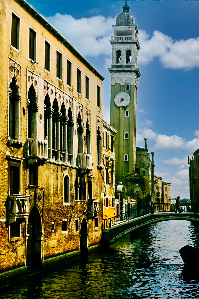
We never realized that Venice has its own leaning tower, the Campanile of San Giorgio dei Greci.
It is amazing how many famous painters were multi-talented artists, who also worked as architects, sculptors and even scientists. Artists were like rock stars and were often known, even today, by their first name alone. For instance, do you know the last names of Michaelangelo, Rafaello, Giotto, Galileo and Leonardo?
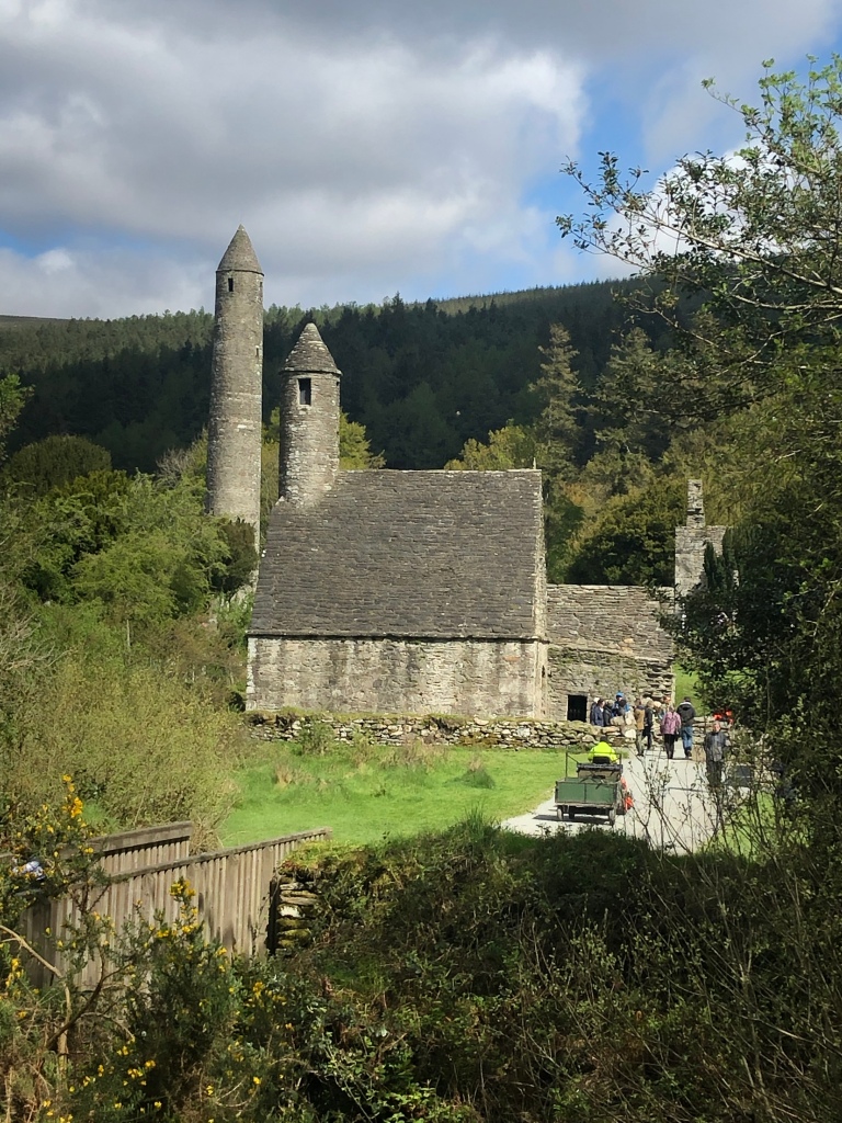
The bell tower tradition started around 400 AD in Italy and around the 9th century the idea spread to Ireland, whose towers are always round.
Many Round Towers are still standing because their round shape is gale-resistant and the section of the tower underneath the high up doorway is packed with soil and stones. The one at Glorious Glendalough is 30.5 m tall.
A more recent one was built in 1935 for the Church of the Four Masters in Donegal.
The following posts provide more details about Rome, Florence and Venice:
These posts answers questions such as:
Our recommendations are not influenced by affiliate links – we have none. Our content and advice is derived from our personal expertise, experience, and knowledge based on living in Europe for seven years and studying its art, architecture and culture.
Ireland North includes wave-pounding coastal views, dramatic cliffs, turquoise-tinged beaches, gorgeous gardens, view-encrusted hikes, and ancient Neolithic ruins. The Ireland North Itinerary includes counties Mayo, Donegal, and Meath in Ireland as well as Derry and Antrim Coast in Northern Ireland.
The 1Σ to 5Σ Sigma score is our Ireland Itinerary Ratings to indicate how we would rank each place. Please add comments or questions about any place and press the Like button at the bottom of each post!
offers turquoise Portacloy bay, peat farms, Neolithic Ceide cliffs, and Downpatrick Head cliff top walk From: Westport, Sligo
offers Colleenamore & Streedagh Beach views, mountain views, Neolithic Carrowmore, Drumcliff Church, and rugged Mullaghmore coastal views. From: Sligo
offers evocative Sligo Abbey, pleasant Glencar Waterfall, and pastoral mountains. From: Sligo
offers Donegal Castle, spectacular Silver Strand, and very high Slieve League cliffs. From: Donegal
visits Napoleon at Maghery Beach, market town Letterkenny, and Victorian B&B in Ramelton From Donegal to Ramelton
offers spectacular views from walks on Horn Head, superb beaches (and gelato) at Marble Hill and Portsalon, pleasant Fanad Head, and scenic road from Portsalon Beach to a seaside fort. From Donegal to Ramelton/Letterkenny
rated 5Σ but could be 6Σ, offers lots of sandy beaches but our favourite is White Rocks, gardens at Downhill Demesne, mainly ruined but photogenic Dunluce Castle, and our favourite hike along the ever-changing Giant’s Causeway Trail. From: Ramelton, Letterkenny, Derry, Bushmills or Ballintoy
offers a very walkable Walled City with old churches, amazingly restored Guildhall (was bombed by IRA), and a poignant reminder of The Troubles, the Bogside Murals. From Ramelton, Letterkenny or Derry
walk through dark passage into centre of amazing burial mound that is older than the Pyramids! From: Trim
quiet town is a good base for Norman era Trim Castle, Bective Abbey, Neolithic Hill of Tara and Newgrange, as well as Dublin Airport 45 minutes away.
Click the map link to see this route, which is described in the above 10 linked posts and needs about 9 days. You will need more time to see the Antrim Coast, Dark Hedges, Carrickfergus Castle, and Belfast.
You may want a couple of days before and after this itinerary for 9 Perfect Places for Dabbling with Dublin and/or Staying Trim. Trim is an excellent base to use to reach Dublin airport.
This post answers questions such as:


You must be logged in to post a comment.